<< Our Photo Pages >> Stane Street (Chichester section) - Ancient Trackway in England in West Sussex
Submitted by CoppellaiaMatta on Wednesday, 27 March 2024 Page Views: 744
Roman, Greek and ClassicalSite Name: Stane Street (Chichester section)Country: England
NOTE: This site is 3.0 km away from the location you searched for.
County: West Sussex Type: Ancient Trackway
Nearest Town: Chichester
Map Ref: SU9713012913
Latitude: 50.907526N Longitude: 0.619911W
Condition:
| 5 | Perfect |
| 4 | Almost Perfect |
| 3 | Reasonable but with some damage |
| 2 | Ruined but still recognisable as an ancient site |
| 1 | Pretty much destroyed, possibly visible as crop marks |
| 0 | No data. |
| -1 | Completely destroyed |
| 5 | Superb |
| 4 | Good |
| 3 | Ordinary |
| 2 | Not Good |
| 1 | Awful |
| 0 | No data. |
| 5 | Can be driven to, probably with disabled access |
| 4 | Short walk on a footpath |
| 3 | Requiring a bit more of a walk |
| 2 | A long walk |
| 1 | In the middle of nowhere, a nightmare to find |
| 0 | No data. |
| 5 | co-ordinates taken by GPS or official recorded co-ordinates |
| 4 | co-ordinates scaled from a detailed map |
| 3 | co-ordinates scaled from a bad map |
| 2 | co-ordinates of the nearest village |
| 1 | co-ordinates of the nearest town |
| 0 | no data |
Internal Links:
External Links:
 (PID:270946)")
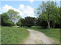
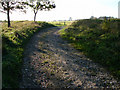
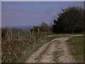
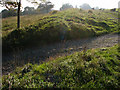
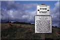
On the maps the bridleway appears perfectly straight. Out in the open, near the top of Bignor Hill, the path is beautifully aligned with the distant spire of Chichester Cathedral.
Unfortunately, following it in the less traipsed parts requires a few turns....to avoid the brambles!
You may be viewing yesterday's version of this page. To see the most up to date information please register for a free account.
 (PID:270947)")
 (PID:270945)")
Do not use the above information on other web sites or publications without permission of the contributor.
Nearby Images from Geograph Britain and Ireland:
©2011(licence)
©2008(licence)
©2010(licence)
©2008(licence)
©2020(licence)
The above images may not be of the site on this page, they are loaded from Geograph.
Please Submit an Image of this site or go out and take one for us!
Click here to see more info for this site
Nearby sites
Key: Red: member's photo, Blue: 3rd party photo, Yellow: other image, Green: no photo - please go there and take one, Grey: site destroyed
Download sites to:
KML (Google Earth)
GPX (GPS waypoints)
CSV (Garmin/Navman)
CSV (Excel)
To unlock full downloads you need to sign up as a Contributory Member. Otherwise downloads are limited to 50 sites.
Turn off the page maps and other distractions
Nearby sites listing. In the following links * = Image available
564m SE 125° Barkhale* Causewayed Enclosure (SU976126)
1.0km ESE 122° Barkhale Tumulus* Round Barrow(s) (SU980124)
1.9km SSW 204° Early Iron Age to Roman Field System, Slindon Misc. Earthwork (SU96391115)
2.3km SW 230° Stane Street standing stones Standing Stones (SU954114)
2.5km W 261° Upwaltham Hill Tumuli* Round Barrow(s) (SU94681250)
2.9km S 176° Prehistoric to Roman Field System Misc. Earthwork (SU97391005)
3.2km ESE 108° Bury Hill (West Sussex) Causewayed Enclosure (TQ002120)
3.6km ESE 123° Cross Dyke, Whiteways Misc. Earthwork (TQ00201101)
4.1km SE 132° War Dyke and Prehistoric Enclosure Misc. Earthwork (TQ00251020)
4.2km SE 128° South Wood Cross Dyke Misc. Earthwork (TQ00541040)
4.5km WNW 292° Oxen Down Tumuli* Barrow Cemetery (SU929145)
4.7km SSE 149° Late Prehistoric and Roman Field systems Misc. Earthwork (SU99640888)
5.3km SW 228° Long Down Flint Mines* Ancient Mine, Quarry or other Industry (SU932093)
5.4km SE 129° Arundel Park Barrow MWS14784 Round Barrow(s) (TQ01360957)
5.4km SSE 169° Goblestubbs Copse earthworks Ancient Village or Settlement (SU983076)
5.5km SE 133° Arundel Park Barrow MWS14521 Round Barrow(s) (TQ01260927)
5.5km SE 133° Arundel Park Barrow MWS14520 Round Barrow(s) (TQ01240924)
5.5km SE 132° Arundel Park Barrow MWS14778 Round Barrow(s) (TQ01310927)
5.6km SE 134° Arundel Barrow MWS14523 Round Barrow(s) (TQ01200909)
5.6km SE 132° Arundel Park Settlements Ancient Village or Settlement (TQ01390928)
5.6km SE 135° Arundel Park Barrow MWS6559 Round Barrow(s) (TQ01190903)
5.6km SE 135° Prehistoric and Roman Field System and Earthworks Misc. Earthwork (TQ01210900)
6.0km SE 138° Arundel Park Ditched Bowl Barrow Round Barrow(s) (TQ01260853)
6.0km SE 137° Arundel Barrow MWS2707 Round Barrow(s) (TQ01360859)
6.0km WSW 239° Halnaker Hill* Causewayed Enclosure (SU920097)
View more nearby sites and additional images


 We would like to know more about this location. Please feel free to add a brief description and any relevant information in your own language.
 Wir möchten mehr über diese Stätte erfahren. Bitte zögern Sie nicht, eine kurze Beschreibung und relevante Informationen in Deutsch hinzuzufügen.
 Nous aimerions en savoir encore un peu sur les lieux. S'il vous plaît n'hesitez pas à ajouter une courte description et tous les renseignements pertinents dans votre propre langue.
 Quisieramos informarnos un poco más de las lugares. No dude en añadir una breve descripción y otros datos relevantes en su propio idioma.