<< Our Photo Pages >> Jugger Howes - Round Barrow(s) in England in Yorkshire (North)
Submitted by johndhunter on Wednesday, 04 November 2020 Page Views: 730
Neolithic and Bronze AgeSite Name: Jugger HowesCountry: England County: Yorkshire (North) Type: Round Barrow(s)
Nearest Village: Ravenscar
Map Ref: NZ9436800173
Latitude: 54.388306N Longitude: 0.548298W
Condition:
| 5 | Perfect |
| 4 | Almost Perfect |
| 3 | Reasonable but with some damage |
| 2 | Ruined but still recognisable as an ancient site |
| 1 | Pretty much destroyed, possibly visible as crop marks |
| 0 | No data. |
| -1 | Completely destroyed |
| 5 | Superb |
| 4 | Good |
| 3 | Ordinary |
| 2 | Not Good |
| 1 | Awful |
| 0 | No data. |
| 5 | Can be driven to, probably with disabled access |
| 4 | Short walk on a footpath |
| 3 | Requiring a bit more of a walk |
| 2 | A long walk |
| 1 | In the middle of nowhere, a nightmare to find |
| 0 | No data. |
| 5 | co-ordinates taken by GPS or official recorded co-ordinates |
| 4 | co-ordinates scaled from a detailed map |
| 3 | co-ordinates scaled from a bad map |
| 2 | co-ordinates of the nearest village |
| 1 | co-ordinates of the nearest town |
| 0 | no data |
Internal Links:
External Links:
")
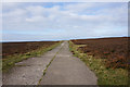
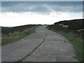
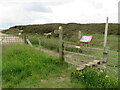
Two adjacent bronze age round barrows know as Jugger Howes* sited in a prominent position at the north east edge of Jugger Howe Moor. They are Historic England List Entry 1019793 which tells us that the barrows are made of stone and earth and lie 10m apart. The north east barrow is 7m in diameter and 0.6m high whilst the south western barrow is 8m in diameter and 0.6m high. There are hollows in both mounds indicating that they have been investigated in the past.
Pastscape also has information at Monument 29785
* Note 1: A little confusing but there is another single barrow ¼ mile to the south west of Jugger Howes known as Jugger Howe
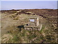
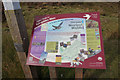
Note 2: The route of Lyke Wake Walk runs close by and the final leg beckons, taking you across Stony Marl Moor and terminating at the Lyke Wake Walk marker stone at NZ 97068 01194 on Stoupe Brow Beacon overlooking Ravenscar. Also at the parking area 150 metres to the east of Jugger Howes at NZ 94510 00248 on the route of the walk is a memorial stone to Pete Gough one of the founder members of the Scarborough and District Search and Rescue Teams.
You may be viewing yesterday's version of this page. To see the most up to date information please register for a free account.
")
")
")
Do not use the above information on other web sites or publications without permission of the contributor.
Nearby Images from Geograph Britain and Ireland:
©2019(licence)
©2010(licence)
©2007(licence)
©2019(licence)
©2023(licence)
The above images may not be of the site on this page, they are loaded from Geograph.
Please Submit an Image of this site or go out and take one for us!
Click here to see more info for this site
Nearby sites
Key: Red: member's photo, Blue: 3rd party photo, Yellow: other image, Green: no photo - please go there and take one, Grey: site destroyed
Download sites to:
KML (Google Earth)
GPX (GPS waypoints)
CSV (Garmin/Navman)
CSV (Excel)
To unlock full downloads you need to sign up as a Contributory Member. Otherwise downloads are limited to 50 sites.
Turn off the page maps and other distractions
Nearby sites listing. In the following links * = Image available
297m NW 316° Burn Howe Dale RB1* Round Barrow(s) (NZ9415800384)
636m NE 35° Stony Marl Ring Cairn 1* Ring Cairn (NZ9472600700)
1.2km NE 50° Grey Horse Stone (Stony Marl Moor)* Standing Stone (Menhir) (NZ9525200936)
1.4km ENE 69° Stony Marl Howes* Barrow Cemetery (NZ9569900725)
1.7km NE 53° The Map Stone (Fylingdales Moor) Rock Art (NZ957012)
2.3km NE 34° Brow Moor RB5* Round Barrow(s) (NZ9563302119)
2.3km ENE 62° Fylingdales Moor, Brow Moor, East Butts, (Area E)* Rock Art (NZ9642001307)
2.4km ENE 62° Brow Moor - Rock 87* Rock Art (NZ9642501323)
2.4km NE 36° Brow Moor RB4* Round Barrow(s) (NZ9572802103)
2.4km ENE 65° Brow Moor - Rock 82* Rock Art (NZ9649401219)
2.4km ENE 62° Brow Moor - Rock 72* Rock Art (NZ9645001320)
2.4km ENE 65° Brow Moor - Rock 80* Rock Art (NZ9650801226)
2.4km ENE 63° Brow Moor - Rock 76* Rock Art (NZ9648201282)
2.4km ENE 64° Brow Moor - Rock 79* Rock Art (NZ9649801261)
2.4km ENE 65° Brow Moor - Rock 83* Rock Art (NZ9651601226)
2.4km E 94° Pye Rigg Howe (Staintondale Moor)* Round Barrow(s) (NZ9677400065)
2.4km ENE 64° Hugh Kendall Stone* Rock Art (NZ9652101275)
2.4km ENE 64° Brow Moor - Rock 78* Rock Art (NZ9652701270)
2.4km ENE 64° Robin Hood's Bay Cup and Ring Stone (Whitby)* Rock Art (NZ9652501274)
2.4km ENE 63° Brow Moor - Rock 74* Rock Art (NZ9650801316)
2.4km NE 41° Brow Moor RB3* Round Barrow(s) (NZ9593602045)
2.5km NE 48° Brow Moor - Rock 2* Rock Art (NZ9615701874)
2.5km NE 44° Brow Moor RB2* Round Barrow(s) (NZ9604301989)
2.5km ENE 71° Brow Moor - Rock 104* Rock Art (NZ9670501011)
2.5km NE 52° Brow Moor SS2* Marker Stone (NZ9629901740)
View more nearby sites and additional images


 We would like to know more about this location. Please feel free to add a brief description and any relevant information in your own language.
 Wir möchten mehr über diese Stätte erfahren. Bitte zögern Sie nicht, eine kurze Beschreibung und relevante Informationen in Deutsch hinzuzufügen.
 Nous aimerions en savoir encore un peu sur les lieux. S'il vous plaît n'hesitez pas à ajouter une courte description et tous les renseignements pertinents dans votre propre langue.
 Quisieramos informarnos un poco más de las lugares. No dude en añadir una breve descripción y otros datos relevantes en su propio idioma.