<< Our Photo Pages >> Taplow Mound - Artificial Mound in England in Buckinghamshire
Submitted by DavidCWoods on Monday, 04 October 2004 Page Views: 15436
Multi-periodSite Name: Taplow Mound Alternative Name: Tæppa's Mound; Tæppa's Low (Taplow), Taeppa's MoundCountry: England County: Buckinghamshire Type: Artificial Mound
Nearest Town: Maidenhead Nearest Village: Taplow
Map Ref: SU90618216
Latitude: 51.531088N Longitude: 0.695137W
Condition:
| 5 | Perfect |
| 4 | Almost Perfect |
| 3 | Reasonable but with some damage |
| 2 | Ruined but still recognisable as an ancient site |
| 1 | Pretty much destroyed, possibly visible as crop marks |
| 0 | No data. |
| -1 | Completely destroyed |
| 5 | Superb |
| 4 | Good |
| 3 | Ordinary |
| 2 | Not Good |
| 1 | Awful |
| 0 | No data. |
| 5 | Can be driven to, probably with disabled access |
| 4 | Short walk on a footpath |
| 3 | Requiring a bit more of a walk |
| 2 | A long walk |
| 1 | In the middle of nowhere, a nightmare to find |
| 0 | No data. |
| 5 | co-ordinates taken by GPS or official recorded co-ordinates |
| 4 | co-ordinates scaled from a detailed map |
| 3 | co-ordinates scaled from a bad map |
| 2 | co-ordinates of the nearest village |
| 1 | co-ordinates of the nearest town |
| 0 | no data |
Be the first person to rate this site - see the 'Contribute!' box in the right hand menu.
Internal Links:
External Links:
I have visited· I would like to visit
SolarMegalith visited on 2nd Jul 2011 - their rating: Cond: 4 Amb: 3 Access: 5
NickyD have visited here
")
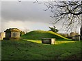
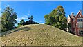
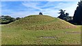
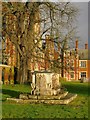
The mound is right next to the house, in the churchyard of a now demolished church.
Taplow Court is sometimes open to the public, and there is apparently a right of way to the mound.
For more information see Pastscape Monument No. 251689 which describes this 7th century 'hlaew' or round barrow. The monument is also scheduled as Historic England List ID 1014781, which covers the Saxon barrow, the church and cemeteries in the old churchyard at Taplow Court.
The Journal of Antiquities also features a page for this site - see their entry for Taeppa’s Low, Taplow, Buckinghamshire, which includes a description, a photograph and a notie of the artefacts found during excavation, which are now in the British Museum. The JoA entry also inclues mention of the nearby well (see nearby sites below), adding: "(this) whole site is surrounded by the earthworks of an Iron-Age fortification which are now barely noticeable to visitors".
You may be viewing yesterday's version of this page. To see the most up to date information please register for a free account.
")
")
")
")
Do not use the above information on other web sites or publications without permission of the contributor.
Nearby Images from Geograph Britain and Ireland:
©2014(licence)
©2014(licence)
©2023(licence)
©2023(licence)
©2014(licence)
The above images may not be of the site on this page, they are loaded from Geograph.
Please Submit an Image of this site or go out and take one for us!
Click here to see more info for this site
Nearby sites
Key: Red: member's photo, Blue: 3rd party photo, Yellow: other image, Green: no photo - please go there and take one, Grey: site destroyed
Download sites to:
KML (Google Earth)
GPX (GPS waypoints)
CSV (Garmin/Navman)
CSV (Excel)
To unlock full downloads you need to sign up as a Contributory Member. Otherwise downloads are limited to 50 sites.
Turn off the page maps and other distractions
Nearby sites listing. In the following links * = Image available
1.0km W 279° Bapsey Pond* Holy Well or Sacred Spring (SU896823)
3.2km S 175° Weir Bank Stud Farm Ancient Village or Settlement (SU90957900)
3.3km NNW 346° Tarry Stone* Marker Stone (SU8974585392)
4.0km NNE 28° Root Mound Round Barrow(s) (SU92438574)
4.8km ENE 60° Seven Ways Plain* Hillfort (SU94718466)
5.5km W 260° Robin Hood's Arbour* Ancient Village or Settlement (SU85188108)
5.8km WSW 254° Maidenhead Thicket Bowl Barrow* Round Barrow(s) (SU850805)
6.2km WNW 292° Princess Elizabeth's Well* Holy Well or Sacred Spring (SU848844)
6.4km ESE 110° Montem mound Artificial Mound (SU9665880045)
6.4km E 90° Stoke Park Bowl Barrow* Round Barrow(s) (SU97038222)
7.7km WNW 292° Low Grounds Farm Barrow Cemetery (SU834849)
9.1km WNW 285° Danesfield Camp* Hillfort (SU81768440)
9.4km S 190° Holyport Modern Stone Circle Modern Stone Circle etc (SU8908672865)
10.0km NNE 30° The Mount (Beaconsfield)* Round Barrow(s) (SU95549089)
10.2km WNW 285° Medmenham Camp* Hillfort (SU80698467)
10.4km NNW 343° Keep Hill Hillfort (SU87379205)
10.5km ENE 57° Bulstrode Camp* Hillfort (SU994880)
10.8km W 262° Rebecca's Well (Crazies Hill)* Holy Well or Sacred Spring (SU7993080487)
11.9km SSW 199° The Quelm Stone* Natural Stone / Erratic / Other Natural Feature (SU870708)
12.4km ESE 122° Kingsmead Quarry Ancient Village or Settlement (TQ01307588)
12.6km NNW 333° Desborough Castle* Hillfort (SU847933)
12.6km W 268° Mont de la Ville* Passage Grave (SU77968140)
13.1km ESE 123° Kingsmead Quarry* Ancient Village or Settlement (TQ01707520)
13.5km S 178° Bowledge Hill Bell Barrow* Round Barrow(s) (SU91336872)
14.4km SSW 196° Bill Hill (Berkshire)* Round Barrow(s) (SU868683)
View more nearby sites and additional images


 We would like to know more about this location. Please feel free to add a brief description and any relevant information in your own language.
 Wir möchten mehr über diese Stätte erfahren. Bitte zögern Sie nicht, eine kurze Beschreibung und relevante Informationen in Deutsch hinzuzufügen.
 Nous aimerions en savoir encore un peu sur les lieux. S'il vous plaît n'hesitez pas à ajouter une courte description et tous les renseignements pertinents dans votre propre langue.
 Quisieramos informarnos un poco más de las lugares. No dude en añadir una breve descripción y otros datos relevantes en su propio idioma.