<< Our Photo Pages >> Pigtrough Rigg Settlement - Ancient Village or Settlement in England in Yorkshire (North)
Submitted by johndhunter on Monday, 16 August 2021 Page Views: 524
Multi-periodSite Name: Pigtrough Rigg SettlementCountry: England County: Yorkshire (North) Type: Ancient Village or Settlement
Nearest Village: Levisham
Map Ref: SE8319492354
Latitude: 54.319999N Longitude: 0.722501W
Condition:
| 5 | Perfect |
| 4 | Almost Perfect |
| 3 | Reasonable but with some damage |
| 2 | Ruined but still recognisable as an ancient site |
| 1 | Pretty much destroyed, possibly visible as crop marks |
| 0 | No data. |
| -1 | Completely destroyed |
| 5 | Superb |
| 4 | Good |
| 3 | Ordinary |
| 2 | Not Good |
| 1 | Awful |
| 0 | No data. |
| 5 | Can be driven to, probably with disabled access |
| 4 | Short walk on a footpath |
| 3 | Requiring a bit more of a walk |
| 2 | A long walk |
| 1 | In the middle of nowhere, a nightmare to find |
| 0 | No data. |
| 5 | co-ordinates taken by GPS or official recorded co-ordinates |
| 4 | co-ordinates scaled from a detailed map |
| 3 | co-ordinates scaled from a bad map |
| 2 | co-ordinates of the nearest village |
| 1 | co-ordinates of the nearest town |
| 0 | no data |
Internal Links:
External Links:

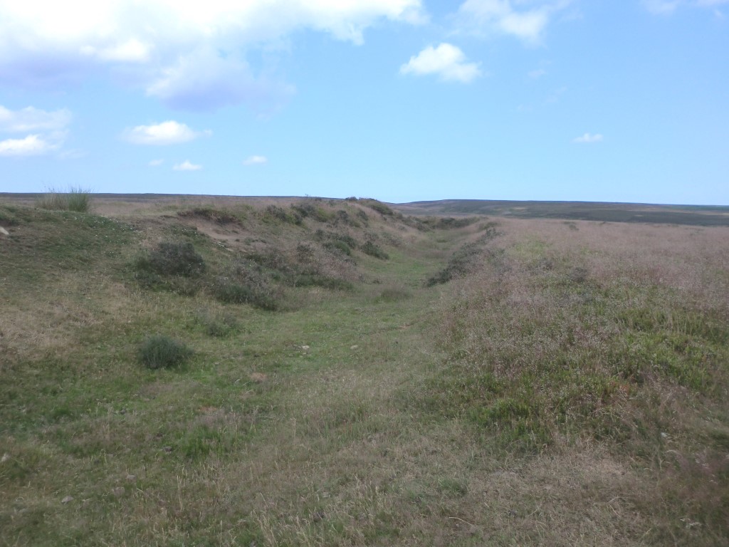
There are numerous historic remains on Levisham Moor ranging from the prehistoric to the medieval. The dispersed enclosed settlement on Pigtrough Rigg is from the Iron Age / Roman period though the dike / entrenchments which enclosed them originate from an earlier time.
Note: These dikes have now been converted to act as drains and on the modern OS maps they are shown as water courses (blue lines). A view of the 1927 OS map shows them as entrenchments and can be viewed HERE. When the map opens, read if required then close the pop up box which obscures it, then zoom in to the right of the image to locate the settlement.
The remains of the settlement are made up of four main components, they are referring to the uploaded sketch map – The War Camp at SE 83194 92354 (Monument 63260), Enclosure ‘A’ at SE 83137 82392 (Monument 63254), Enclosure ‘B’ at SE 8306 9220 (Monument 63263) and the Bloomery at SE 83020 92209(Monument 63275).
Historic England List Entry 1020820 is a large entry which covers all the historical remains from the prehistoric to the medieval on Levisham Moor including information on the settlement. The basic information provided below is obtained from this List Entry and the HERR monument numbers whose links are provided above next to the map references. Note: The settlement dates from the first century AD also dimensions given by the List Entry tend to differ slightly to those given by the HERR
The War Camp is its local name and is the largest of the enclosures. It is irregular shaped, varying from 50m to 60m east to west and 50m to 54m north to south. Originally surrounded by a ditch and rampart the southern section has since been destroyed with the ditch filled in and superimposed by a medieval ridge and furrow. Excavation in the 1950’s and 1960’s indicates that its primary use was for domestic occupation.
Enclosure ‘A’ to the north west of the War Camp measures 50m east to west and 45m north to south. Excavations within the interior in the 1960’s found two irregular shaped hut circles approx 12m in diameter.
Enclosure ‘B’ 200m to the south west of the War Camp has according to the List Entry the same measurements as Enclosure ‘A’ however the HERR says its internal measurements are 39m x 37m also there is some confusion as to its usage. The List Entry states that its primary use was for domestic occupation whilst the HERR states that the enclosure represents either a small field or pastoral fold.
Bloomery to the west of enclosure ‘B’ is heavily overgrown and I found it difficult to make anything out. Excavations in the 1960’s found that the site contained a circular hut about 20ft in diameter, housing a bloomery, this was enclosed by two penannular ditches 33ft and 48ft in diameter. Today the bloomery is indicated on the modern OS map as a mound, this is the same icon as used for a tumulus.
A condensed 1983 description of the bloomery by Raymond Hayes* is as follows:
‘Ironworking site with concentric penannular ditches around an iron smelting furnace and associated timber shelter. The furnace was intact being 1m in diameter and 0.5m deep with the remains of a shaft or chimney. It was lined with slag and had been rebuilt at least three times. Associated pottery finds within the area suggest a date between 2nd century BC and the 1st century AD.
*Hayes, R H, 1988, North-East Yorkshire Studies: Archaeological Papers, page 53
Note: Both the War Camp and Enclosures ‘A’ and ‘B’ can be clearly seen when viewed with satellite imagery, not so the Bloomery I can’t make anything out, others may. Satellite imagery can be accessed be clicking on one of the aeroplane icons at the top of this site page.
You may be viewing yesterday's version of this page. To see the most up to date information please register for a free account.


Do not use the above information on other web sites or publications without permission of the contributor.
Click here to see more info for this site
Nearby sites
Key: Red: member's photo, Blue: 3rd party photo, Yellow: other image, Green: no photo - please go there and take one, Grey: site destroyed
Download sites to:
KML (Google Earth)
GPX (GPS waypoints)
CSV (Garmin/Navman)
CSV (Excel)
To unlock full downloads you need to sign up as a Contributory Member. Otherwise downloads are limited to 50 sites.
Turn off the page maps and other distractions
Nearby sites listing. In the following links * = Image available
172m SE 145° Levisham Moor South RB1* Round Barrow(s) (SE8329592214)
439m SSW 199° Dundale Rigg RB1* Round Barrow(s) (SE8306091935)
462m NW 304° Levisham Moor South RB2* Round Barrow(s) (SE8280792608)
501m N 11° Sheephouse Rigg RB1* Round Barrow(s) (SE8328192848)
798m NNW 346° Levisham Moor Cross Dyke South* Misc. Earthwork (SE8298893126)
1.1km N 2° Levisham Moor Cross Dyke North* Misc. Earthwork (SE8322293450)
1.3km N 3° Seavy Pond Round Barrows* Barrow Cemetery (SE8324893610)
1.7km S 181° The Dragon Stone* Early Christian Sculptured Stone (SE832907)
2.1km NE 37° Levisham Moor North RB1* Round Barrow(s) (SE8446294083)
2.2km SSE 157° St Robert's Holy Well* Holy Well or Sacred Spring (SE841903)
2.4km NE 43° Gallows Dyke* Misc. Earthwork (SE84849416)
3.0km WSW 241° Black Howe (Rawcliffe)* Cairn (SE80599087)
3.1km SSW 207° Penny Howe Round Barrow(s) (SE81808955)
3.3km NE 54° Cross Dyke on Saltergate Brow* Misc. Earthwork (SE8587194356)
3.5km WSW 252° Rawcliffe Howe* Cairn (SE799912)
3.5km NW 322° Brown Howe* Round Barrow(s) (SE80989508)
4.1km WNW 295° Old Wives' Well* Holy Well or Sacred Spring (SE7943894057)
4.1km ENE 77° Blakey Topping* Stone Circle (SE87199338)
4.1km WNW 301° Mauley Cross* Ancient Cross (SE796944)
4.2km ESE 107° The Bridestones (Staindale)* Natural Stone / Erratic / Other Natural Feature (SE872912)
4.3km NE 54° Malo Cross* Ancient Cross (SE8667594943)
4.7km NW 316° Keys Beck Road* Standing Stones (SE79899570)
4.7km NE 46° Saltergate Moor* Stone Row / Alignment (SE865957)
5.1km ESE 117° Adder Stone (Dalby Forest)* Natural Stone / Erratic / Other Natural Feature (SE8778090110)
5.3km WSW 243° Cawthorne Square Barrow* Round Barrow(s) (SE78458987)
View more nearby sites and additional images


 We would like to know more about this location. Please feel free to add a brief description and any relevant information in your own language.
 Wir möchten mehr über diese Stätte erfahren. Bitte zögern Sie nicht, eine kurze Beschreibung und relevante Informationen in Deutsch hinzuzufügen.
 Nous aimerions en savoir encore un peu sur les lieux. S'il vous plaît n'hesitez pas à ajouter une courte description et tous les renseignements pertinents dans votre propre langue.
 Quisieramos informarnos un poco más de las lugares. No dude en añadir una breve descripción y otros datos relevantes en su propio idioma.