<< Our Photo Pages >> In Moor. - Cairn in England in Yorkshire (North)
Submitted by Anonymous on Monday, 01 March 2010 Page Views: 5493
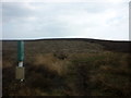
Neolithic and Bronze AgeSite Name: In Moor. Alternative Name: Murk Mire MoorCountry: England
NOTE: This site is 0.8 km away from the location you searched for.
County: Yorkshire (North) Type: Cairn
Nearest Town: Goathland Nearest Village: Struntry Carr
Map Ref: NZ805025
Latitude: 54.411592N Longitude: 0.761167W
Condition:
| 5 | Perfect |
| 4 | Almost Perfect |
| 3 | Reasonable but with some damage |
| 2 | Ruined but still recognisable as an ancient site |
| 1 | Pretty much destroyed, possibly visible as crop marks |
| 0 | No data. |
| -1 | Completely destroyed |
| 5 | Superb |
| 4 | Good |
| 3 | Ordinary |
| 2 | Not Good |
| 1 | Awful |
| 0 | No data. |
| 5 | Can be driven to, probably with disabled access |
| 4 | Short walk on a footpath |
| 3 | Requiring a bit more of a walk |
| 2 | A long walk |
| 1 | In the middle of nowhere, a nightmare to find |
| 0 | No data. |
| 5 | co-ordinates taken by GPS or official recorded co-ordinates |
| 4 | co-ordinates scaled from a detailed map |
| 3 | co-ordinates scaled from a bad map |
| 2 | co-ordinates of the nearest village |
| 1 | co-ordinates of the nearest town |
| 0 | no data |
Internal Links:
External Links:
")
Marked on the OS map as a field system , this site was exposed by a moor fire in October 2009. Aerial photographs in the local press revealed at least 20 cairns and its age is estimated at 4500 years.
You may be viewing yesterday's version of this page. To see the most up to date information please register for a free account.
")
")
")
")
Do not use the above information on other web sites or publications without permission of the contributor.
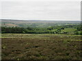
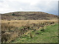
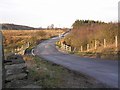
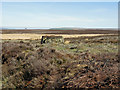
Nearby Images from Geograph Britain and Ireland:
©2023(licence)
©2017(licence)
©2007(licence)
©2015(licence)
©2011(licence)
The above images may not be of the site on this page, they are loaded from Geograph.
Please Submit an Image of this site or go out and take one for us!
Click here to see more info for this site
Nearby sites
Key: Red: member's photo, Blue: 3rd party photo, Yellow: other image, Green: no photo - please go there and take one, Grey: site destroyed
Download sites to:
KML (Google Earth)
GPX (GPS waypoints)
CSV (Garmin/Navman)
CSV (Excel)
To unlock full downloads you need to sign up as a Contributory Member. Otherwise downloads are limited to 50 sites.
Turn off the page maps and other distractions
Nearby sites listing. In the following links * = Image available
1.7km SW 217° Three Howes (Egton High Moor)* Round Cairn (NZ7946301098)
2.0km E 96° Pennock Puzzle Stone* Carving (NZ8252902337)
2.2km E 83° Allan Tofts 5c* Rock Art (NZ8265502816)
2.4km E 81° Allan Tofts 4b* Rock Art (NZ8283002928)
2.5km E 85° Allan Tofts 7* Rock Art (NZ8294502747)
2.5km SSW 195° Wheeldale Stones* Marker Stone (NZ79900010)
2.5km E 79° Allan Tofts 2g* Rock Art (NZ8294903016)
2.5km SSE 146° Hunt House Road Standing Stone* Marker Stone (NZ8192900430)
2.5km E 79° Allan Tofts 2e* Rock Art (NZ8298903016)
2.6km ENE 78° Allan Tofts 2c* Rock Art (NZ8300503059)
2.6km ENE 78° Allan Tofts 2b* Rock Art (NZ8300503083)
2.6km E 79° Allan Tofts 2d* Rock Art (NZ8303503047)
2.7km E 84° Allan Tofts 9* Rock Art (NZ8316902842)
2.8km W 278° Grange Head MS1 (Egton)* Marker Stone (NZ7770302835)
2.8km WNW 293° William Howe Rigg - Cross Dyke North* Misc. Earthwork (NZ7787203569)
2.9km WNW 293° William Howe Rigg RB1* Round Barrow(s) (NZ7783003571)
2.9km WNW 291° William Howe Mound* Round Cairn (NZ7775803508)
2.9km WNW 288° William Howe Rigg Settlement* Ancient Village or Settlement (NZ7769203358)
3.0km WNW 287° William Howe Rigg - Cross Dyke South* Misc. Earthwork (NZ7762703317)
3.2km WSW 250° Pike Hill Marker Stone (Egton High Moor)* Marker Stone (NZ7750601379)
3.3km W 279° Dog Howe* Round Cairn (NZ7722702935)
3.4km WSW 251° Pike Hill Round Cairns (Egton High Moor)* Round Cairn (NZ7728101328)
3.5km SSE 165° Hunt House Road Waymarkers* Marker Stone (SE8146299159)
3.6km ENE 76° Stony Rigg RB1 (Goathland Moor)* Round Barrow(s) (NZ8395703441)
3.7km SSE 147° Two Howes Rigg* Round Barrow(s) (SE8252899444)
View more nearby sites and additional images


 We would like to know more about this location. Please feel free to add a brief description and any relevant information in your own language.
 Wir möchten mehr über diese Stätte erfahren. Bitte zögern Sie nicht, eine kurze Beschreibung und relevante Informationen in Deutsch hinzuzufügen.
 Nous aimerions en savoir encore un peu sur les lieux. S'il vous plaît n'hesitez pas à ajouter une courte description et tous les renseignements pertinents dans votre propre langue.
 Quisieramos informarnos un poco más de las lugares. No dude en añadir una breve descripción y otros datos relevantes en su propio idioma.