 with our Megalithic Portal iPhone app")

<< Our Photo Pages >> Old Wives' Well - Holy Well or Sacred Spring in England in Yorkshire (North)
Submitted by vagabondnma on Wednesday, 14 March 2007 Page Views: 12391
Springs and Holy WellsSite Name: Old Wives' WellCountry: England County: Yorkshire (North) Type: Holy Well or Sacred Spring
Nearest Town: Stape Nearest Village: Pickering
Map Ref: SE7943894057
Latitude: 54.335898N Longitude: 0.779777W
Condition:
| 5 | Perfect |
| 4 | Almost Perfect |
| 3 | Reasonable but with some damage |
| 2 | Ruined but still recognisable as an ancient site |
| 1 | Pretty much destroyed, possibly visible as crop marks |
| 0 | No data. |
| -1 | Completely destroyed |
| 5 | Superb |
| 4 | Good |
| 3 | Ordinary |
| 2 | Not Good |
| 1 | Awful |
| 0 | No data. |
| 5 | Can be driven to, probably with disabled access |
| 4 | Short walk on a footpath |
| 3 | Requiring a bit more of a walk |
| 2 | A long walk |
| 1 | In the middle of nowhere, a nightmare to find |
| 0 | No data. |
| 5 | co-ordinates taken by GPS or official recorded co-ordinates |
| 4 | co-ordinates scaled from a detailed map |
| 3 | co-ordinates scaled from a bad map |
| 2 | co-ordinates of the nearest village |
| 1 | co-ordinates of the nearest town |
| 0 | no data |
Internal Links:
External Links:
I have visited· I would like to visit
mooonwitch would like to visit
Nemloddolmen visited on 4th Jul 2023 - their rating: Cond: 3 Amb: 3 Access: 4 Moss currently covering the inscription, but someones added some windchimes to the tree above for an aire of magic.
Anne T visited on 1st Oct 2016 - their rating: Cond: 3 Amb: 4 Access: 5 Old Wives' Well, just south of Mauley Cross, near Stape, North Yorkshire: With this well only 223 metres south of the Mauley Cross, we decided to walk down the narrow metalled road ((Keys Beck Road) to the well. Again, Chrispy’s directions were spot on. This time, the rally cars were back, appearing every minute or so and we had to ensure we were visible to the drivers at all times (sometimes difficult with the bracken at the sides of the road being so high). Walking southwards back down towards Stape Village, reaching the first passing place on the left hand side of the road, a small track leads through the grass. About 20-30 metres into the wood we glimpsed a wooden rail which partially surrounds the well, then the well itself came into site.
With a simple stone built ‘hood’ over it, into which there is writing carved into the lintel, this is a very enigmatic spot. The well basin was full of water and a small tickle cut its way through the peat floor of the wood, heading south west down hill towards the road.
There were plenty of old ribbons and scarves (even a sock!) tied to the trees around the well.
According to the Pastscape Record for this monument, number 60532, the lettering on the lintel reads: "Nattie Fonten L M Natalis" (Roman governor of 3 provinces 120AD).
chrispy visited on 26th Apr 2011 - their rating: Cond: 5 Amb: 4 Access: 4 This is a lovely peaceful site just off the road and hidden from view by a few trees. There is no sign to the well but look for a 'passing place' along the side of the road and park there otherwise continue along the road until you come to a wide forest road and Mauley Cross, park there and walk back over. there is a grass path to the well, however it is uneven and would be difficult to push a wheelchair along, especailly as the path and in front of the well is often squelchy.
I have visited the site a lot in the last few years and I have found (and left) offerings there
kelpie have visited here
Average ratings for this site from all visit loggers: Condition: 3.67 Ambience: 3.67 Access: 4.33
")
Until recently, surrounding trees were decorated in colourful ribbons etc...but there are none here today. There is an inscription on the capstone but it is not easy to make out and is probably fairly recent. Mauley Cross is not far away. See Pastscape Monument 60532 record for further details. (updated 2nd October 2016)
You may be viewing yesterday's version of this page. To see the most up to date information please register for a free account.
")
")
")
")
")
")
")
")
")
")
")
")
")
")
")
")
")
Do not use the above information on other web sites or publications without permission of the contributor.
Click here to see more info for this site
Nearby sites
Key: Red: member's photo, Blue: 3rd party photo, Yellow: other image, Green: no photo - please go there and take one, Grey: site destroyed
Download sites to:
KML (Google Earth)
GPX (GPS waypoints)
CSV (Garmin/Navman)
CSV (Excel)
To unlock full downloads you need to sign up as a Contributory Member. Otherwise downloads are limited to 50 sites.
Turn off the page maps and other distractions
Nearby sites listing. In the following links * = Image available
379m NNE 26° Mauley Cross* Ancient Cross (SE796944)
1.5km WNW 284° Leaf Howe* Barrow Cemetery (SE780944)
1.6km WNW 291° High Muffles Tumulus* Round Barrow(s) (SE7789694630)
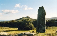
1.7km NNE 16° Keys Beck Road* Standing Stones (SE79899570)
1.8km ENE 57° Brown Howe* Round Barrow(s) (SE80989508)
2.9km S 172° Rawcliffe Howe* Cairn (SE799912)
3.4km SSE 161° Black Howe (Rawcliffe)* Cairn (SE80599087)
3.7km ESE 114° Levisham Moor South RB2* Round Barrow(s) (SE8280792608)
3.7km ESE 106° Levisham Moor Cross Dyke South* Misc. Earthwork (SE8298893126)
3.8km E 100° Levisham Moor Cross Dyke North* Misc. Earthwork (SE8322293450)
3.8km E 98° Seavy Pond Round Barrows* Barrow Cemetery (SE8324893610)
3.9km NNE 19° Wheeldale Roman Road* Misc. Earthwork (SE8064697796)
4.0km ESE 108° Sheephouse Rigg RB1* Round Barrow(s) (SE8328192848)
4.1km ESE 115° Pigtrough Rigg Settlement* Ancient Village or Settlement (SE8319492354)
4.2km ESE 121° Dundale Rigg RB1* Round Barrow(s) (SE8306091935)
4.2km N 11° Wheeldale Moor East* Round Barrow(s) (SE8015098224)
4.3km ESE 117° Levisham Moor South RB1* Round Barrow(s) (SE8329592214)
4.3km NNE 29° Howl Moor Dike* Standing Stone (Menhir) (SE8147297819)
4.3km NNE 27° Hunt House Crag Settlement* Ancient Village or Settlement (SE8135097885)
4.3km SSW 203° Cawthorn Cart Burial Misc. Earthwork (SE778901)
4.3km SSW 194° Cawthorne Square Barrow* Round Barrow(s) (SE78458987)
4.4km NW 318° Black Moor Marker Stone 1* Marker Stone (SE7640997278)
4.4km NNE 21° Skivick Crag Round Cairn* Round Cairn (SE8097298225)
4.5km NNE 20° Skivick Crag Cists* Cist (SE8091098335)
4.5km SSW 201° Cawthorne Banks Tumulus* Cairn (SE779898)
View more nearby sites and additional images


 We would like to know more about this location. Please feel free to add a brief description and any relevant information in your own language.
 Wir möchten mehr über diese Stätte erfahren. Bitte zögern Sie nicht, eine kurze Beschreibung und relevante Informationen in Deutsch hinzuzufügen.
 Nous aimerions en savoir encore un peu sur les lieux. S'il vous plaît n'hesitez pas à ajouter une courte description et tous les renseignements pertinents dans votre propre langue.
 Quisieramos informarnos un poco más de las lugares. No dude en añadir una breve descripción y otros datos relevantes en su propio idioma.