


<< Our Photo Pages >> High Muffles Tumulus - Round Barrow(s) in England in Yorkshire (North)
Submitted by vagabondnma on Thursday, 15 March 2007 Page Views: 6312
Neolithic and Bronze AgeSite Name: High Muffles Tumulus Alternative Name: Old Wife's Mound,Country: England County: Yorkshire (North) Type: Round Barrow(s)
Nearest Town: Pickering Nearest Village: Stape
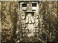
Map Ref: SE7789694630
Latitude: 54.341284N Longitude: 0.803337W
Condition:
| 5 | Perfect |
| 4 | Almost Perfect |
| 3 | Reasonable but with some damage |
| 2 | Ruined but still recognisable as an ancient site |
| 1 | Pretty much destroyed, possibly visible as crop marks |
| 0 | No data. |
| -1 | Completely destroyed |
| 5 | Superb |
| 4 | Good |
| 3 | Ordinary |
| 2 | Not Good |
| 1 | Awful |
| 0 | No data. |
| 5 | Can be driven to, probably with disabled access |
| 4 | Short walk on a footpath |
| 3 | Requiring a bit more of a walk |
| 2 | A long walk |
| 1 | In the middle of nowhere, a nightmare to find |
| 0 | No data. |
| 5 | co-ordinates taken by GPS or official recorded co-ordinates |
| 4 | co-ordinates scaled from a detailed map |
| 3 | co-ordinates scaled from a bad map |
| 2 | co-ordinates of the nearest village |
| 1 | co-ordinates of the nearest town |
| 0 | no data |
Internal Links:
External Links:
")
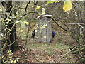
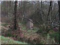
A ruined cairn/barrow (square?) or 'tumulus' according to the O.S.
This is very similar to the two tumuli found near Cawthorne Roman Practice Camp. A similar size, shape and height. With a square-ish outer embankment and a large dip in the middle. Hard to find and covered in bracken. Made all the worse by recent de-forestation.
You may be viewing yesterday's version of this page. To see the most up to date information please register for a free account.
")
")
Do not use the above information on other web sites or publications without permission of the contributor.
Nearby Images from Geograph Britain and Ireland:
©2018(licence)

©2013(licence)
©2023(licence)
©2006(licence)
©2006(licence)
The above images may not be of the site on this page, they are loaded from Geograph.
Please Submit an Image of this site or go out and take one for us!
Click here to see more info for this site
Nearby sites
Key: Red: member's photo, Blue: 3rd party photo, Yellow: other image, Green: no photo - please go there and take one, Grey: site destroyed
Download sites to:
KML (Google Earth)
GPX (GPS waypoints)
CSV (Garmin/Navman)
CSV (Excel)
To unlock full downloads you need to sign up as a Contributory Member. Otherwise downloads are limited to 50 sites.
Turn off the page maps and other distractions
Nearby sites listing. In the following links * = Image available
252m SSE 157° Leaf Howe* Barrow Cemetery (SE780944)
1.6km ESE 111° Old Wives' Well* Holy Well or Sacred Spring (SE7943894057)
1.7km E 99° Mauley Cross* Ancient Cross (SE796944)
2.3km ENE 63° Keys Beck Road* Standing Stones (SE79899570)
3.0km NNW 332° Black Moor Marker Stone 1* Marker Stone (SE7640997278)
3.1km E 83° Brown Howe* Round Barrow(s) (SE80989508)
3.2km NNW 332° Long Stone (Black Moor)* Marker Stone (SE7631497446)
4.0km SSE 151° Rawcliffe Howe* Cairn (SE799912)
4.1km N 11° Raven Stones (Wheeldale Moor)* Natural Stone / Erratic / Other Natural Feature (SE7859498723)
4.2km NE 42° Wheeldale Roman Road* Misc. Earthwork (SE8064697796)
4.2km NNE 33° Wheeldale Moor East* Round Barrow(s) (SE8015098224)
4.3km WSW 249° Abrahams Hut (Spaunton Moor)* Round Cairn (SE7394093016)
4.5km S 182° Cawthorn Cart Burial Misc. Earthwork (SE778901)
4.5km SW 216° Black Park* Standing Stone (Menhir) (SE753909)
4.6km SE 145° Black Howe (Rawcliffe)* Cairn (SE80599087)
4.7km NE 41° Skivick Crag Round Cairn* Round Cairn (SE8097298225)
4.7km NE 48° Hunt House Crag Settlement* Ancient Village or Settlement (SE8135097885)
4.8km NE 40° Skivick Crag Cists* Cist (SE8091098335)
4.8km NNW 344° Blue Man-i'-th'-Moss Standing Stone.* Standing Stone (Menhir) (SE7649899198)
4.8km NE 49° Howl Moor Dike* Standing Stone (Menhir) (SE8147297819)
4.8km S 174° Cawthorne Square Barrow* Round Barrow(s) (SE78458987)
4.8km S 181° Cawthorne Banks Tumulus* Cairn (SE779898)
4.8km WSW 258° Redman Cross* Ancient Cross (SE7315893568)
4.9km NNW 346° Wheeldale Howe* Round Cairn (SE7665599351)
5.1km NE 48° House Crag (Howl Moor)* Stone Circle (SE816981)
View more nearby sites and additional images


 We would like to know more about this location. Please feel free to add a brief description and any relevant information in your own language.
 Wir möchten mehr über diese Stätte erfahren. Bitte zögern Sie nicht, eine kurze Beschreibung und relevante Informationen in Deutsch hinzuzufügen.
 Nous aimerions en savoir encore un peu sur les lieux. S'il vous plaît n'hesitez pas à ajouter une courte description et tous les renseignements pertinents dans votre propre langue.
 Quisieramos informarnos un poco más de las lugares. No dude en añadir una breve descripción y otros datos relevantes en su propio idioma.