<< Our Photo Pages >> Wheeldale Howe - Round Cairn in England in Yorkshire (North)
Submitted by johndhunter on Monday, 23 October 2017 Page Views: 1953
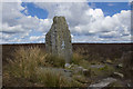
Neolithic and Bronze AgeSite Name: Wheeldale HoweCountry: England County: Yorkshire (North) Type: Round Cairn
Map Ref: SE7665599351
Latitude: 54.383891N Longitude: 0.821207W
Condition:
| 5 | Perfect |
| 4 | Almost Perfect |
| 3 | Reasonable but with some damage |
| 2 | Ruined but still recognisable as an ancient site |
| 1 | Pretty much destroyed, possibly visible as crop marks |
| 0 | No data. |
| -1 | Completely destroyed |
| 5 | Superb |
| 4 | Good |
| 3 | Ordinary |
| 2 | Not Good |
| 1 | Awful |
| 0 | No data. |
| 5 | Can be driven to, probably with disabled access |
| 4 | Short walk on a footpath |
| 3 | Requiring a bit more of a walk |
| 2 | A long walk |
| 1 | In the middle of nowhere, a nightmare to find |
| 0 | No data. |
| 5 | co-ordinates taken by GPS or official recorded co-ordinates |
| 4 | co-ordinates scaled from a detailed map |
| 3 | co-ordinates scaled from a bad map |
| 2 | co-ordinates of the nearest village |
| 1 | co-ordinates of the nearest town |
| 0 | no data |
Be the first person to rate this site - see the 'Contribute!' box in the right hand menu.
Internal Links:
External Links:
")
This is Historic England List Entry Number 1021255 and full details and description can be found there.
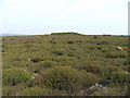
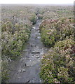
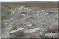
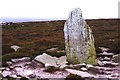
An extract of the entry reads the cairn "is situated on Middle Jurassic sandstone on the North York Moors. It occupies a prominent ridge-top position between Wheeldale Moor and Egton High Moor. The cairn has a well-defined sub-circular mound constructed from stone rubble, which measures up to 21m in diameter and stands up to 1.5m high. Partial excavation in the past has left a hollow in the centre of the mound. To the north of the centre there is a small modern walkers' cairn on the top of the mound. The cairn is one of a number in the area which lie on the central watershed of the North York Moors. It is surrounded by many other prehistoric monuments, particularly, those associated with burials."
You may be viewing yesterday's version of this page. To see the most up to date information please register for a free account.
")
")
Do not use the above information on other web sites or publications without permission of the contributor.
Nearby Images from Geograph Britain and Ireland:
©2006(licence)
©2011(licence)
©2011(licence)
©2005(licence)
©2010(licence)
The above images may not be of the site on this page, they are loaded from Geograph.
Please Submit an Image of this site or go out and take one for us!
Click here to see more info for this site
Nearby sites
Key: Red: member's photo, Blue: 3rd party photo, Yellow: other image, Green: no photo - please go there and take one, Grey: site destroyed
Download sites to:
KML (Google Earth)
GPX (GPS waypoints)
CSV (Garmin/Navman)
CSV (Excel)
To unlock full downloads you need to sign up as a Contributory Member. Otherwise downloads are limited to 50 sites.
Turn off the page maps and other distractions
Nearby sites listing. In the following links * = Image available
219m SW 227° Blue Man-i'-th'-Moss Standing Stone.* Standing Stone (Menhir) (SE7649899198)
1.9km S 191° Long Stone (Black Moor)* Marker Stone (SE7631497446)
2.0km ESE 109° Raven Stones (Wheeldale Moor)* Natural Stone / Erratic / Other Natural Feature (SE7859498723)
2.1km NNE 18° Pike Hill Round Cairns (Egton High Moor)* Round Cairn (NZ7728101328)
2.1km S 188° Black Moor Marker Stone 1* Marker Stone (SE7640997278)
2.1km NW 308° Yarlsey Hill Waymarker Stone* Standing Stone (Menhir) (NZ7495700636)
2.2km NNE 24° Pike Hill Marker Stone (Egton High Moor)* Marker Stone (NZ7750601379)
2.5km WNW 291° Goose i' th' nest* Marker Stone (NZ7431100201)
2.8km WNW 304° Traverse Moor RB1* Round Barrow(s) (NZ7431200856)
3.0km W 277° Shunner Howe* Round Barrow(s) (SE7370299686)
3.3km WNW 302° Flat Howe (Glaisdale High Moor)* Round Barrow(s) (NZ7382801025)
3.3km ENE 59° Three Howes (Egton High Moor)* Round Cairn (NZ7946301098)
3.3km ENE 78° Wheeldale Stones* Marker Stone (NZ79900010)
3.6km WNW 303° Flat Howe Guide Stones* Marker Stone (NZ7362601275)
3.6km N 10° Dog Howe* Round Cairn (NZ7722702935)
3.6km NNE 18° Grange Head MS1 (Egton)* Marker Stone (NZ7770302835)
3.7km ESE 109° Wheeldale Moor East* Round Barrow(s) (SE8015098224)
3.7km NW 306° Grey Mare Stone (Glaisdale)* Marker Stone (NZ7361601491)
4.1km NNE 15° William Howe Rigg - Cross Dyke South* Misc. Earthwork (NZ7762703317)
4.1km NNE 15° William Howe Rigg Settlement* Ancient Village or Settlement (NZ7769203358)
4.3km ESE 112° Wheeldale Roman Road* Misc. Earthwork (SE8064697796)
4.3km NNE 16° William Howe Mound* Round Cairn (NZ7775803508)
4.4km ESE 104° Skivick Crag Cists* Cist (SE8091098335)
4.4km NNE 16° William Howe Rigg RB1* Round Barrow(s) (NZ7783003571)
4.4km NNE 17° William Howe Rigg - Cross Dyke North* Misc. Earthwork (NZ7787203569)
View more nearby sites and additional images


 We would like to know more about this location. Please feel free to add a brief description and any relevant information in your own language.
 Wir möchten mehr über diese Stätte erfahren. Bitte zögern Sie nicht, eine kurze Beschreibung und relevante Informationen in Deutsch hinzuzufügen.
 Nous aimerions en savoir encore un peu sur les lieux. S'il vous plaît n'hesitez pas à ajouter une courte description et tous les renseignements pertinents dans votre propre langue.
 Quisieramos informarnos un poco más de las lugares. No dude en añadir una breve descripción y otros datos relevantes en su propio idioma.