<< Text Pages >> Boltby Scar Camp - Hillfort in England in Yorkshire (North)
Submitted by vicky on Sunday, 21 July 2002 Page Views: 8224
Iron Age and Later PrehistorySite Name: Boltby Scar Camp Alternative Name: Hill Fort WindypitCountry: England County: Yorkshire (North) Type: Hillfort
Map Ref: SE506857 Landranger Map Number: 100
Latitude: 54.264467N Longitude: 1.224649W
Condition:
| 5 | Perfect |
| 4 | Almost Perfect |
| 3 | Reasonable but with some damage |
| 2 | Ruined but still recognisable as an ancient site |
| 1 | Pretty much destroyed, possibly visible as crop marks |
| 0 | No data. |
| -1 | Completely destroyed |
| 5 | Superb |
| 4 | Good |
| 3 | Ordinary |
| 2 | Not Good |
| 1 | Awful |
| 0 | No data. |
| 5 | Can be driven to, probably with disabled access |
| 4 | Short walk on a footpath |
| 3 | Requiring a bit more of a walk |
| 2 | A long walk |
| 1 | In the middle of nowhere, a nightmare to find |
| 0 | No data. |
| 5 | co-ordinates taken by GPS or official recorded co-ordinates |
| 4 | co-ordinates scaled from a detailed map |
| 3 | co-ordinates scaled from a bad map |
| 2 | co-ordinates of the nearest village |
| 1 | co-ordinates of the nearest town |
| 0 | no data |
Be the first person to rate this site - see the 'Contribute!' box in the right hand menu.
Internal Links:
External Links:
Hillfort in North Yorshire
Have you visited this site? Please add a comment below.
You may be viewing yesterday's version of this page. To see the most up to date information please register for a free account.
Do not use the above information on other web sites or publications without permission of the contributor.
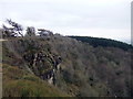
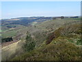
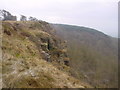
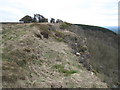
Nearby Images from Geograph Britain and Ireland:
©2018(licence)
©2020(licence)
©2006(licence)
©2010(licence)
©2019(licence)
The above images may not be of the site on this page, they are loaded from Geograph.
Please Submit an Image of this site or go out and take one for us!
Click here to see more info for this site
Nearby sites
Key: Red: member's photo, Blue: 3rd party photo, Yellow: other image, Green: no photo - please go there and take one, Grey: site destroyed
Download sites to:
KML (Google Earth)
GPX (GPS waypoints)
CSV (Garmin/Navman)
CSV (Excel)
To unlock full downloads you need to sign up as a Contributory Member. Otherwise downloads are limited to 50 sites.
Turn off the page maps and other distractions
Nearby sites listing. In the following links * = Image available
584m SE 134° Hambleton Down North* Round Barrow(s) (SE5102885301)
2.1km SSE 167° Sutton Bank Round Barrow* Round Barrow(s) (SE5108283684)
2.9km SSE 161° Cooper Cross (Sutton Bank)* Ancient Cross (SE5157082994)
3.5km E 93° Kirby Ley* Round Barrow(s) (SE5408985584)
4.0km WSW 255° Howe Hill (Felixkirk)* Round Barrow(s) (SE46738463)
4.2km NNE 31° Sunny Bank Barrows* Round Barrow(s) (SE527893)
4.2km S 170° Roulston Scar Camp Hillfort (SE514816)
4.2km SSE 159° High Town round cairn Cairn (SE52138179)
4.2km NW 323° Windygill Ridge RB2 (Cowesby Moor)* Round Barrow(s) (SE4800089010)
4.2km NW 319° Seta Pike (Cowesby Moor) Round Barrow(s) (SE4778288840)
4.3km NW 325° Windygill Ridge RB1 (Cowesby Moor)* Round Barrow(s) (SE4809589170)
4.4km SSE 168° Roulston Scar Barrow Round Barrow(s) (SE51538139)
4.5km S 184° Hood Hill Stone Natural Stone / Erratic / Other Natural Feature (SE50378125)
4.5km S 170° Kilburn White Horse* Hill Figure or Geoglyph (SE51438129)
4.5km SSE 168° High Town Brow Round Barrow(s) (SE51598128)
4.6km NNW 337° Friar's Cross (Kepwick)* Ancient Cross (SE4879589908)
4.6km NNW 347° Steeple Cross (Arden Little Moor)* Ancient Cross (SE4950490155)
4.8km NNW 331° Gallow Hill Tumuli (Cowesby Moor)* Round Barrow(s) (SE4819789858)
4.8km NNW 343° Kepwick Long Barrow* Long Barrow (SE4915590333)
5.0km NE 38° All Saints Church, Hawnby* Ancient Cross (SE53658967)
5.5km NW 326° Penhill Gate Tumuli* Barrow Cemetery (SE4745390251)
5.9km SSE 148° Cockerdale Wood Cairn Cairn (SE53838075)
6.2km N 358° Harker Yates Ridge (Arden Great Moor)* Round Barrow(s) (SE5032691940)
7.0km N 9° Sun Burnt Nab (Arden Great Moor)* Round Barrow(s) (SE5160292649)
7.1km N 7° Sun Bank (Arden Great Moor)* Round Barrow(s) (SE5136892782)
View more nearby sites and additional images


 We would like to know more about this location. Please feel free to add a brief description and any relevant information in your own language.
 Wir möchten mehr über diese Stätte erfahren. Bitte zögern Sie nicht, eine kurze Beschreibung und relevante Informationen in Deutsch hinzuzufügen.
 Nous aimerions en savoir encore un peu sur les lieux. S'il vous plaît n'hesitez pas à ajouter une courte description et tous les renseignements pertinents dans votre propre langue.
 Quisieramos informarnos un poco más de las lugares. No dude en añadir una breve descripción y otros datos relevantes en su propio idioma.