

<< Our Photo Pages >> Magdalen Hill Down - Barrow Cemetery in England in Hampshire
Submitted by SolarMegalith on Tuesday, 15 November 2011 Page Views: 7053
Neolithic and Bronze AgeSite Name: Magdalen Hill DownCountry: England County: Hampshire Type: Barrow Cemetery
Nearest Town: Winchester
Map Ref: SU49992933
Latitude: 51.061139N Longitude: 1.288039W
Condition:
| 5 | Perfect |
| 4 | Almost Perfect |
| 3 | Reasonable but with some damage |
| 2 | Ruined but still recognisable as an ancient site |
| 1 | Pretty much destroyed, possibly visible as crop marks |
| 0 | No data. |
| -1 | Completely destroyed |
| 5 | Superb |
| 4 | Good |
| 3 | Ordinary |
| 2 | Not Good |
| 1 | Awful |
| 0 | No data. |
| 5 | Can be driven to, probably with disabled access |
| 4 | Short walk on a footpath |
| 3 | Requiring a bit more of a walk |
| 2 | A long walk |
| 1 | In the middle of nowhere, a nightmare to find |
| 0 | No data. |
| 5 | co-ordinates taken by GPS or official recorded co-ordinates |
| 4 | co-ordinates scaled from a detailed map |
| 3 | co-ordinates scaled from a bad map |
| 2 | co-ordinates of the nearest village |
| 1 | co-ordinates of the nearest town |
| 0 | no data |
Internal Links:
External Links:
I have visited· I would like to visit
SolarMegalith visited on 11th Nov 2011 - their rating: Cond: 3 Amb: 4 Access: 4
")
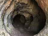
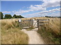
Barrows A and E are almost completely mutilated. Barrow B is located right from the footpath (walking from Winchester) and is 2 m high. Barrow C has remains of a robber trench in it's top part, but is still very obvious. Barrow D is the largest one, it is 2,5 m high and has partly preserved quarry ditch.
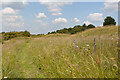
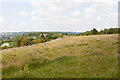
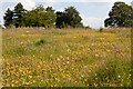
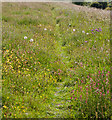
Area of the barrow cemetery is protected as Magdalen Hill Down Nature Reserve with many rare species of butterflies.
You may be viewing yesterday's version of this page. To see the most up to date information please register for a free account.
")
")
")
")
Do not use the above information on other web sites or publications without permission of the contributor.
Nearby Images from Geograph Britain and Ireland:
©2011(licence)
©2011(licence)
©2011(licence)
©2013(licence)
©2011(licence)
The above images may not be of the site on this page, they are loaded from Geograph.
Please Submit an Image of this site or go out and take one for us!
Click here to see more info for this site
Nearby sites
Key: Red: member's photo, Blue: 3rd party photo, Yellow: other image, Green: no photo - please go there and take one, Grey: site destroyed
Download sites to:
KML (Google Earth)
GPX (GPS waypoints)
CSV (Garmin/Navman)
CSV (Excel)
To unlock full downloads you need to sign up as a Contributory Member. Otherwise downloads are limited to 50 sites.
Turn off the page maps and other distractions
Nearby sites listing. In the following links * = Image available
1.8km W 266° Winchester Cathedral Wells* Holy Well or Sacred Spring (SU482292)
1.9km W 273° Winchester City Museum* Museum (SU4809729407)
1.9km SSW 208° The Dongas* Ancient Trackway (SU491276)
2.0km SSW 211° Twyford Down monument* Modern Stone Circle etc (SU48962757)
2.2km SW 223° Mizmaze* Maze or Labyrinth (SU48482769)
2.3km SW 224° St Catherine's Hill (Hampshire)* Hillfort (SU48422766)
2.3km W 275° Hampshire Jubilee Sculpture* Modern Stone Circle etc (SU477295)
2.4km ESE 121° Telegraph Hill Bowl Barrow* Round Barrow(s) (SU521281)
2.5km W 279° Oram's Arbour Hillfort (SU475297)
3.0km ESE 122° Cheesefoot Head Barrows* Barrow Cemetery (SU52572777)
4.2km SW 230° Compton Down Barrows* Round Barrow(s) (SU46762660)
4.5km SSE 155° Morestead Warren* Long Barrow (SU519253)
4.7km SSW 204° Twyford stone circle* Stone Circle (SU481250)
4.9km NW 304° Flowerdown Barrows* Barrow Cemetery (SU459320)
5.0km WSW 243° Texas Barrows* Round Barrow(s) (SU4558926993)
6.0km SE 146° Longwood Barrow Long Barrow (SU534244)
7.3km NNW 338° South Wonston* Barrow Cemetery (SU4723736091)
7.5km W 272° West Wood Bowl Barrow* Round Barrow(s) (SU42522949)
7.5km NE 48° Itchen Stoke Down Barrows Round Barrow(s) (SU5554334384)
8.0km NNE 25° Micheldever Wood Banjo Enclosure* Ancient Village or Settlement (SU53353658)
8.1km NNE 24° Micheldever Wood Bell Barrow* Round Barrow(s) (SU53213678)
8.4km NNE 20° Micheldever Wood Bowl Barrow* Round Barrow(s) (SU52773721)
8.4km WSW 250° Merdon Castle* Hillfort (SU421264)
8.6km W 270° Robin Hood's Barrow (Winchester)* Round Barrow(s) (SU41322927)
9.3km E 96° Cheriton Long Barrow* Long Barrow (SU5926328419)
View more nearby sites and additional images


 We would like to know more about this location. Please feel free to add a brief description and any relevant information in your own language.
 Wir möchten mehr über diese Stätte erfahren. Bitte zögern Sie nicht, eine kurze Beschreibung und relevante Informationen in Deutsch hinzuzufügen.
 Nous aimerions en savoir encore un peu sur les lieux. S'il vous plaît n'hesitez pas à ajouter une courte description et tous les renseignements pertinents dans votre propre langue.
 Quisieramos informarnos un poco más de las lugares. No dude en añadir una breve descripción y otros datos relevantes en su propio idioma.