<< Our Photo Pages >> Kitson's Clump - Round Barrow(s) in England in Hampshire
Submitted by SolarMegalith on Friday, 14 October 2011 Page Views: 3610
Neolithic and Bronze AgeSite Name: Kitson's ClumpCountry: England County: Hampshire Type: Round Barrow(s)
Nearest Town: Winchester Nearest Village: Sutton Scotney
Map Ref: SU47454010
Latitude: 51.158192N Longitude: 1.322868W
Condition:
| 5 | Perfect |
| 4 | Almost Perfect |
| 3 | Reasonable but with some damage |
| 2 | Ruined but still recognisable as an ancient site |
| 1 | Pretty much destroyed, possibly visible as crop marks |
| 0 | No data. |
| -1 | Completely destroyed |
| 5 | Superb |
| 4 | Good |
| 3 | Ordinary |
| 2 | Not Good |
| 1 | Awful |
| 0 | No data. |
| 5 | Can be driven to, probably with disabled access |
| 4 | Short walk on a footpath |
| 3 | Requiring a bit more of a walk |
| 2 | A long walk |
| 1 | In the middle of nowhere, a nightmare to find |
| 0 | No data. |
| 5 | co-ordinates taken by GPS or official recorded co-ordinates |
| 4 | co-ordinates scaled from a detailed map |
| 3 | co-ordinates scaled from a bad map |
| 2 | co-ordinates of the nearest village |
| 1 | co-ordinates of the nearest town |
| 0 | no data |
Internal Links:
External Links:
I have visited· I would like to visit
SolarMegalith visited on 14th Oct 2011 - their rating: Cond: 3 Amb: 3 Access: 4
")
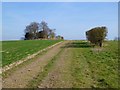
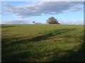
A pair of Bronze Age round barrows on Kitson’s Clump consists of a bowl barrow (the western one) and a bell barrow (the eastern one). The bowl barrow is 21 m in diameter, while the bell barrow is 24 m in diameter. Height of both barrows does not exceed 1,5 m. No traces of a quarry ditches have survived.
Kitson’s Clump barrows are easily accessable, they are located near the footpath leading through ridge of the hill.
Read More at Pastscape.
You may be viewing yesterday's version of this page. To see the most up to date information please register for a free account.
")
")
")
")
Do not use the above information on other web sites or publications without permission of the contributor.
Nearby Images from Geograph Britain and Ireland:
©2012(licence)
©2012(licence)
©2012(licence)
©2014(licence)

©2006(licence)
The above images may not be of the site on this page, they are loaded from Geograph.
Please Submit an Image of this site or go out and take one for us!
Click here to see more info for this site
Nearby sites
Key: Red: member's photo, Blue: 3rd party photo, Yellow: other image, Green: no photo - please go there and take one, Grey: site destroyed
Download sites to:
KML (Google Earth)
GPX (GPS waypoints)
CSV (Garmin/Navman)
CSV (Excel)
To unlock full downloads you need to sign up as a Contributory Member. Otherwise downloads are limited to 50 sites.
Turn off the page maps and other distractions
Nearby sites listing. In the following links * = Image available
1.6km E 91° Norsebury Ring* Hillfort (SU491401)
2.0km WSW 243° Sutton Scotney Enclosure* Misc. Earthwork (SU457392)
2.8km NNE 32° Cranbourne Farm Long Barrow* Long Barrow (SU4894442495)
3.1km NNW 337° Tidbury Ring* Hillfort (SU462429)
4.0km S 184° South Wonston* Barrow Cemetery (SU4723736091)
4.2km NNE 30° Norton Wood Bowl Barrow* Round Barrow(s) (SU49504375)
5.2km NNE 27° Freefolk Wood Bell Barrow* Round Barrow(s) (SU49764474)
5.2km NNE 26° Freefolk Wood Bowl Barrow* Round Barrow(s) (SU49694481)
5.5km NE 38° Three Barrows (Laverstoke)* Barrow Cemetery (SU50794442)
5.9km WSW 253° Middlebarn Farm Long Barrow Long Barrow (SU4177438299)
6.0km ESE 119° Micheldever Wood Bowl Barrow* Round Barrow(s) (SU52773721)
6.3km NE 53° Popham Beacons* Barrow Cemetery (SU525439)
6.6km ESE 121° Micheldever Wood Bell Barrow* Round Barrow(s) (SU53213678)
6.9km ESE 121° Micheldever Wood Banjo Enclosure* Ancient Village or Settlement (SU53353658)
7.6km NNE 24° Turrill Hill Bowl Barrows* Round Barrow(s) (SU5052247092)
7.8km N 350° All Hallows (Whitchurch) Early Christian Sculptured Stone (SU45994775)
7.8km NNE 22° Abra Barrow* Round Barrow(s) (SU5030947359)
8.2km SSW 191° Flowerdown Barrows* Barrow Cemetery (SU459320)
8.3km W 275° St Peter and Holy Cross (Wherwell) Ancient Cross (SU39154082)
9.0km WNW 301° Old Pound Camp Misc. Earthwork (SU39634465)
9.9km SE 126° Itchen Stoke Down Barrows Round Barrow(s) (SU5554334384)
10.4km S 180° Oram's Arbour Hillfort (SU475297)
10.4km NE 48° St Nicholas (Steventon) Ancient Cross (SU55104722)
10.5km WSW 243° Woolbury* Hillfort (SU381353)
10.6km S 179° Hampshire Jubilee Sculpture* Modern Stone Circle etc (SU477295)
View more nearby sites and additional images


 We would like to know more about this location. Please feel free to add a brief description and any relevant information in your own language.
 Wir möchten mehr über diese Stätte erfahren. Bitte zögern Sie nicht, eine kurze Beschreibung und relevante Informationen in Deutsch hinzuzufügen.
 Nous aimerions en savoir encore un peu sur les lieux. S'il vous plaît n'hesitez pas à ajouter une courte description et tous les renseignements pertinents dans votre propre langue.
 Quisieramos informarnos un poco más de las lugares. No dude en añadir una breve descripción y otros datos relevantes en su propio idioma.