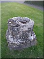
<< Our Photo Pages >> Cup and Saucer Stone - Ancient Cross in England in Oxfordshire
Submitted by vicky on Saturday, 06 December 2003 Page Views: 13070
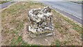
Medieval (High and Late)Site Name: Cup and Saucer StoneCountry: England County: Oxfordshire Type: Ancient Cross
Nearest Town: Banbury Nearest Village: Cropredy
Map Ref: SP466466 Landranger Map Number: 151
Latitude: 52.115765N Longitude: 1.320874W
Condition:
| 5 | Perfect |
| 4 | Almost Perfect |
| 3 | Reasonable but with some damage |
| 2 | Ruined but still recognisable as an ancient site |
| 1 | Pretty much destroyed, possibly visible as crop marks |
| 0 | No data. |
| -1 | Completely destroyed |
| 5 | Superb |
| 4 | Good |
| 3 | Ordinary |
| 2 | Not Good |
| 1 | Awful |
| 0 | No data. |
| 5 | Can be driven to, probably with disabled access |
| 4 | Short walk on a footpath |
| 3 | Requiring a bit more of a walk |
| 2 | A long walk |
| 1 | In the middle of nowhere, a nightmare to find |
| 0 | No data. |
| 5 | co-ordinates taken by GPS or official recorded co-ordinates |
| 4 | co-ordinates scaled from a detailed map |
| 3 | co-ordinates scaled from a bad map |
| 2 | co-ordinates of the nearest village |
| 1 | co-ordinates of the nearest town |
| 0 | no data |
Internal Links:
External Links:
I have visited· I would like to visit
Majick123 visited on 2nd Aug 2013 - their rating: Cond: 2 Amb: 3 Access: 5 Clearly the base of the Old Village Cross, which has been weathered and worn down over many years. Just up the road from the Braisnose Arms and a Short Walk to the Red lion.
")
You may be viewing yesterday's version of this page. To see the most up to date information please register for a free account.
")
")
Do not use the above information on other web sites or publications without permission of the contributor.
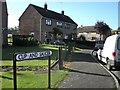
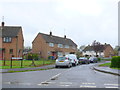
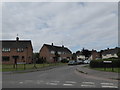
Nearby Images from Geograph Britain and Ireland:
©2010(licence)
©2013(licence)
©2016(licence)
©2022(licence)
©2019(licence)
The above images may not be of the site on this page, they are loaded from Geograph.
Please Submit an Image of this site or go out and take one for us!
Click here to see more info for this site
Nearby sites
Key: Red: member's photo, Blue: 3rd party photo, Yellow: other image, Green: no photo - please go there and take one, Grey: site destroyed
Download sites to:
KML (Google Earth)
GPX (GPS waypoints)
CSV (Garmin/Navman)
CSV (Excel)
To unlock full downloads you need to sign up as a Contributory Member. Otherwise downloads are limited to 50 sites.
Turn off the page maps and other distractions
Nearby sites listing. In the following links * = Image available
446m ESE 117° Ringstone (Cropredy) Stone Circle (SP470464)
3.4km NE 55° Arbury Camp* Hillfort (SP494486)
7.7km WNW 282° Nadbury Camp* Hillfort (SP390482)
8.3km NE 38° Byfield Cross Plinth Ancient Cross (SP516532)
8.4km NW 306° Holy Well (Burton Dassett)* Holy Well or Sacred Spring (SP398515)
9.0km S 177° Bodicote Cursus Cursus (SP472376)
10.5km NW 306° Burton Dassett Tumuli Round Barrow(s) (SP380526)
10.9km SSE 158° St Rumbald's Well* Holy Well or Sacred Spring (SP50783651)
11.0km SW 226° Madmarston Hill* Hillfort (SP38653890)
11.1km SSE 159° Astrop Well* Holy Well or Sacred Spring (SP50603624)
11.3km W 262° Red Horse of Tysoe Hill Figure or Geoglyph (SP3539844833)
12.2km SW 219° Tadmarton Holy Well* Holy Well or Sacred Spring (SP3937)
13.2km SSE 154° Rainsborough Camp* Hillfort (SP526348)
13.4km SW 216° Tadmarton Camp* Hillfort (SP38783568)
14.2km NNE 32° Arbury hill Hillfort (SP540587)
15.7km NNW 342° Holy Well (Southam)* Holy Well or Sacred Spring (SP417615)
16.3km S 190° Ilbury Camp* Hillfort (SP438305)
19.2km WNW 281° Ettington Cursus Cursus (SP277502)
19.2km WNW 282° Ettington Cursus Cursus (SP277504)
19.4km SSE 165° Somerton Turf Maze (SP5187927901)
19.5km ENE 59° The Larches Ancient Village or Settlement (SP633567)
20.1km NE 38° Borough Hill (Daventry)* Hillfort (SP588626)
20.3km NW 309° Oakley Wood Fort* Hillfort (SP306592)
20.8km NNE 20° Holy Well, Braunston* Holy Well or Sacred Spring (SP537662)
22.0km WNW 297° Charlecote B Cursus Cursus (SP268563)
View more nearby sites and additional images


 We would like to know more about this location. Please feel free to add a brief description and any relevant information in your own language.
 Wir möchten mehr über diese Stätte erfahren. Bitte zögern Sie nicht, eine kurze Beschreibung und relevante Informationen in Deutsch hinzuzufügen.
 Nous aimerions en savoir encore un peu sur les lieux. S'il vous plaît n'hesitez pas à ajouter une courte description et tous les renseignements pertinents dans votre propre langue.
 Quisieramos informarnos un poco más de las lugares. No dude en añadir una breve descripción y otros datos relevantes en su propio idioma.