<< Our Photo Pages >> Pudding Pie Hill - Round Barrow(s) in England in Yorkshire (North)
Submitted by rogerkread on Friday, 12 September 2014 Page Views: 7583
Neolithic and Bronze AgeSite Name: Pudding Pie HillCountry: England County: Yorkshire (North) Type: Round Barrow(s)
Nearest Town: Thirsk Nearest Village: Sowerby
Map Ref: SE437810
Latitude: 54.222865N Longitude: 1.331258W
Condition:
| 5 | Perfect |
| 4 | Almost Perfect |
| 3 | Reasonable but with some damage |
| 2 | Ruined but still recognisable as an ancient site |
| 1 | Pretty much destroyed, possibly visible as crop marks |
| 0 | No data. |
| -1 | Completely destroyed |
| 5 | Superb |
| 4 | Good |
| 3 | Ordinary |
| 2 | Not Good |
| 1 | Awful |
| 0 | No data. |
| 5 | Can be driven to, probably with disabled access |
| 4 | Short walk on a footpath |
| 3 | Requiring a bit more of a walk |
| 2 | A long walk |
| 1 | In the middle of nowhere, a nightmare to find |
| 0 | No data. |
| 5 | co-ordinates taken by GPS or official recorded co-ordinates |
| 4 | co-ordinates scaled from a detailed map |
| 3 | co-ordinates scaled from a bad map |
| 2 | co-ordinates of the nearest village |
| 1 | co-ordinates of the nearest town |
| 0 | no data |
Internal Links:
External Links:
I have visited· I would like to visit
Chappers60 visited on 1st Feb 2025 - their rating: Cond: 3 Amb: 3 Access: 4
Catrinm visited on 12th Oct 2019 - their rating: Cond: 3 Access: 5
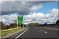
Anne T visited on 26th Sep 2014 - their rating: Cond: 3 Amb: 4 Access: 4 Pudding Pie Hill, Sowerby near Thirsk: From St Mary The Virgin at Leake, we headed south to Thirsk, leaving the A19 at its junction with the A168 to get as close as we could to Pudding Pie Hill.
It wasn’t possible to get to the round barrow from this direction, as there are all private roads leading to houses and small holdings, so we tried driving back into Thirsk and back round to Sowerby.
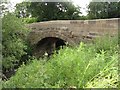
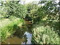
I always like coming to Thirsk, but never been to Sowerby, and it’s a really quaint little village. Blakey Bridge was closed to traffic so we walked across, through the field with Cod Beck to our right hand side.
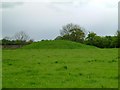
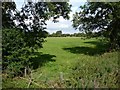
The barrow rises up out of what appears to be the flood plain for the Cod Beck. If it weren’t for the very busy A168 roaring past on the eastern side, this barrow would be in a lovely spot indeed.
There is an information board by the footpath leading up to the barrow which explains something of the history and has old photographs of children on the barrow.
We walked up to the top of the mound, and there is indeed a hollow where they excavated it in the nineteenth century.
The ditch around the mound can be seen to its eastern and southern sides. Definitely worth coming to visit briefly.
Average ratings for this site from all visit loggers: Condition: 3 Ambience: 3.5 Access: 4.33
")
Pudding Pie Hill is a large bowl barrow dating from the Late Neolithic to the Bronze Age, 2400-1500 BC, according to the information board on site. Little remains of the ditch. An indentation on the summit is the consequence of a nineteenth century attempt at excavation. This found the remains of three male skeletons dated to the 6th century AD, showing re-use of the site in the early mediaeval period. It now lies immediately adjacent to the Thirsk bypass (A19), and planning has recently been granted for a large housing development in nearby fields, thus accounting for the relatively low ambience rating. Well worth a visit nevertheless.
You may be viewing yesterday's version of this page. To see the most up to date information please register for a free account.
")
")
")
")
Do not use the above information on other web sites or publications without permission of the contributor.
Nearby Images from Geograph Britain and Ireland:
©2005(licence)
©2016(licence)
©2008(licence)
©2010(licence)
©2010(licence)
The above images may not be of the site on this page, they are loaded from Geograph.
Please Submit an Image of this site or go out and take one for us!
Click here to see more info for this site
Nearby sites
Key: Red: member's photo, Blue: 3rd party photo, Yellow: other image, Green: no photo - please go there and take one, Grey: site destroyed
Download sites to:
KML (Google Earth)
GPX (GPS waypoints)
CSV (Garmin/Navman)
CSV (Excel)
To unlock full downloads you need to sign up as a Contributory Member. Otherwise downloads are limited to 50 sites.
Turn off the page maps and other distractions
Nearby sites listing. In the following links * = Image available
4.7km NE 40° Howe Hill (Felixkirk)* Round Barrow(s) (SE46738463)
6.6km SSW 206° Maiden's Bower (Asenby)* Turf Maze (SE409750)
6.7km E 88° Hood Hill Stone Natural Stone / Erratic / Other Natural Feature (SE50378125)
7.7km E 86° Roulston Scar Camp Hillfort (SE514816)
7.7km E 88° Kilburn White Horse* Hill Figure or Geoglyph (SE51438129)
7.8km E 88° Roulston Scar Barrow Round Barrow(s) (SE51538139)
7.8km ENE 71° Sutton Bank Round Barrow* Round Barrow(s) (SE5108283684)
7.9km E 89° High Town Brow Round Barrow(s) (SE51598128)
8.1km ENE 76° Cooper Cross (Sutton Bank)* Ancient Cross (SE5157082994)
8.3km NE 56° Boltby Scar Camp Hillfort (SE506857)
8.4km E 85° High Town round cairn Cairn (SE52138179)
8.5km ENE 60° Hambleton Down North* Round Barrow(s) (SE5102885301)
8.6km N 353° St. Helen's Well (Borrowby) Holy Well or Sacred Spring (SE425895)
8.8km NNE 28° Seta Pike (Cowesby Moor) Round Barrow(s) (SE4778288840)
9.1km NNE 29° Windygill Ridge RB2 (Cowesby Moor)* Round Barrow(s) (SE4800089010)
9.3km NNE 29° Windygill Ridge RB1 (Cowesby Moor)* Round Barrow(s) (SE4809589170)
9.4km WNW 288° All Saints (Pickhill)* Ancient Cross (SE3471583751)
9.4km W 271° Sinderby* Henge (SE34288100)
9.5km WNW 287° Money Hill (Pickhill)* Artificial Mound (SE3451583693)
9.6km N 358° St Mary (Leake)* Ancient Cross (SE43329063)
9.9km W 267° Quernhow (Ainderby Quernhow) Cairn (SE33818045)
9.9km NNE 27° Gallow Hill Tumuli (Cowesby Moor)* Round Barrow(s) (SE4819789858)
10.0km NNE 23° Penhill Gate Tumuli* Barrow Cemetery (SE4745390251)
10.1km E 92° Cockerdale Wood Cairn Cairn (SE53838075)
10.2km NNE 30° Friar's Cross (Kepwick)* Ancient Cross (SE4879589908)
View more nearby sites and additional images


 We would like to know more about this location. Please feel free to add a brief description and any relevant information in your own language.
 Wir möchten mehr über diese Stätte erfahren. Bitte zögern Sie nicht, eine kurze Beschreibung und relevante Informationen in Deutsch hinzuzufügen.
 Nous aimerions en savoir encore un peu sur les lieux. S'il vous plaît n'hesitez pas à ajouter une courte description et tous les renseignements pertinents dans votre propre langue.
 Quisieramos informarnos un poco más de las lugares. No dude en añadir una breve descripción y otros datos relevantes en su propio idioma.