


<< Our Photo Pages >> Sturt Henge - Modern Stone Circle etc in England in Oxfordshire
Submitted by h_fenton on Tuesday, 02 September 2008 Page Views: 7007
Modern SitesSite Name: Sturt HengeCountry: England
NOTE: This site is 0.4 km away from the location you searched for.
County: Oxfordshire Type: Modern Stone Circle etc
Nearest Town: Charlbury
Map Ref: SP36111899
Latitude: 51.868324N Longitude: 1.476959W
Condition:
| 5 | Perfect |
| 4 | Almost Perfect |
| 3 | Reasonable but with some damage |
| 2 | Ruined but still recognisable as an ancient site |
| 1 | Pretty much destroyed, possibly visible as crop marks |
| 0 | No data. |
| -1 | Completely destroyed |
| 5 | Superb |
| 4 | Good |
| 3 | Ordinary |
| 2 | Not Good |
| 1 | Awful |
| 0 | No data. |
| 5 | Can be driven to, probably with disabled access |
| 4 | Short walk on a footpath |
| 3 | Requiring a bit more of a walk |
| 2 | A long walk |
| 1 | In the middle of nowhere, a nightmare to find |
| 0 | No data. |
| 5 | co-ordinates taken by GPS or official recorded co-ordinates |
| 4 | co-ordinates scaled from a detailed map |
| 3 | co-ordinates scaled from a bad map |
| 2 | co-ordinates of the nearest village |
| 1 | co-ordinates of the nearest town |
| 0 | no data |
Internal Links:
External Links:
I have visited· I would like to visit
h_fenton has visited here
")
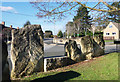
Oxfordshire County Council had the idea of setting up a "Home Zone" in Hughes Close and Sturt Close in Charlbury. through the use of chicanes and tree planting the traffic on these streets has been slowed down making is safer for children to play on the street. At the entrance to Hughes close Sturt henge was erected and some words carved into them which a poet and local residents came up with.
The stones themselves look best from behind since the front of the stones have been sawn flat so that the local kids can put graffiti on the stones and it does not take to much effort for the council to get it all off.
You may be viewing yesterday's version of this page. To see the most up to date information please register for a free account.
")
Do not use the above information on other web sites or publications without permission of the contributor.
coldrum has found this location on Google Street View:
Nearby Images from Geograph Britain and Ireland:
©2019(licence)
©2019(licence)
©2007(licence)

©2016(licence)
©2015(licence)
The above images may not be of the site on this page, they are loaded from Geograph.
Please Submit an Image of this site or go out and take one for us!
Click here to see more info for this site
Nearby sites
Key: Red: member's photo, Blue: 3rd party photo, Yellow: other image, Green: no photo - please go there and take one, Grey: site destroyed
Download sites to:
KML (Google Earth)
GPX (GPS waypoints)
CSV (Garmin/Navman)
CSV (Excel)
To unlock full downloads you need to sign up as a Contributory Member. Otherwise downloads are limited to 50 sites.
Turn off the page maps and other distractions
Nearby sites listing. In the following links * = Image available
825m WSW 256° Cornbury Park Round Barrow(s) (SP35311878)
2.9km NE 49° Model Farm Ancient Village or Settlement (SP383209)
2.9km N 358° Thorsbrook Spring* Holy Well or Sacred Spring (SP360219)
3.1km N 357° Thor Stone* Standing Stone (Menhir) (SP35932208)
3.6km SW 234° Churchill Copse* Long Barrow (SP33161685)
4.1km SW 233° Slatepits Copse* Chambered Tomb (SP329165)
4.4km SSE 163° The Lady's Well (Oxfordshire)* Holy Well or Sacred Spring (SP374148)
4.5km WSW 251° High Lodge Tumuli Round Barrow(s) (SP318175)
4.7km W 265° Smallstones Farm Long Barrow (SP31411852)
4.8km ENE 59° Home Farm Ancient Village or Settlement (SP402215)
5.0km SE 135° North Leigh Roman Villa* Ancient Village or Settlement (SP39661547)
5.0km NNE 20° Hoar Stone at Enstone* Chambered Tomb (SP37792375)
5.0km NNW 335° Hawk Stone* Standing Stone (Menhir) (SP3392023540)
5.5km ENE 71° Out Wood & Berrings Wood Ancient Village or Settlement (SP413208)
5.8km ENE 66° Grimsdyke Farm Ancient Village or Settlement (SP41402141)
6.0km NW 312° Knollbury Enclosure* Ancient Village or Settlement (SP316230)
6.2km E 84° Glympton Farm Ancient Village or Settlement (SP423197)
6.3km WSW 258° Ascott under Wychwood* Chambered Tomb (SP299176)
6.5km WSW 257° Coldwell Bridge Long Barrow 2* Long Barrow (SP29751745)
6.6km E 96° Blenheim Great Park Ancient Village or Settlement (SP427183)
6.6km WNW 292° Lyneham Camp* Hillfort (SP299214)
6.7km WNW 289° Lyneham Long Barrow* Long Barrow (SP29752107)
7.9km ESE 109° Fair Rosamund's Well* Holy Well or Sacred Spring (SP43651646)
8.1km SSW 198° Churchill Plain Chambered Tomb (SP33711129)
8.1km WNW 300° Old Vicarage* Standing Stone (Menhir) (SP290230)
View more nearby sites and additional images


 We would like to know more about this location. Please feel free to add a brief description and any relevant information in your own language.
 Wir möchten mehr über diese Stätte erfahren. Bitte zögern Sie nicht, eine kurze Beschreibung und relevante Informationen in Deutsch hinzuzufügen.
 Nous aimerions en savoir encore un peu sur les lieux. S'il vous plaît n'hesitez pas à ajouter une courte description et tous les renseignements pertinents dans votre propre langue.
 Quisieramos informarnos un poco más de las lugares. No dude en añadir una breve descripción y otros datos relevantes en su propio idioma.