<< Our Photo Pages >> All Saints (Pickhill) - Ancient Cross in England in Yorkshire (North)
Submitted by Anne T on Tuesday, 16 May 2017 Page Views: 2318
Early Medieval (Dark Age)Site Name: All Saints (Pickhill)Country: England
NOTE: This site is 0.2 km away from the location you searched for.
County: Yorkshire (North) Type: Ancient Cross
Nearest Town: Thirsk Nearest Village: Pickhill
Map Ref: SE3471583751
Latitude: 54.248273N Longitude: 1.468739W
Condition:
| 5 | Perfect |
| 4 | Almost Perfect |
| 3 | Reasonable but with some damage |
| 2 | Ruined but still recognisable as an ancient site |
| 1 | Pretty much destroyed, possibly visible as crop marks |
| 0 | No data. |
| -1 | Completely destroyed |
| 5 | Superb |
| 4 | Good |
| 3 | Ordinary |
| 2 | Not Good |
| 1 | Awful |
| 0 | No data. |
| 5 | Can be driven to, probably with disabled access |
| 4 | Short walk on a footpath |
| 3 | Requiring a bit more of a walk |
| 2 | A long walk |
| 1 | In the middle of nowhere, a nightmare to find |
| 0 | No data. |
| 5 | co-ordinates taken by GPS or official recorded co-ordinates |
| 4 | co-ordinates scaled from a detailed map |
| 3 | co-ordinates scaled from a bad map |
| 2 | co-ordinates of the nearest village |
| 1 | co-ordinates of the nearest town |
| 0 | no data |
Internal Links:
External Links:
I have visited· I would like to visit
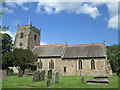
Anne T visited on 11th May 2017 - their rating: Cond: 3 Amb: 4 Access: 5 Hogback and Cross Fragments, Pickhill, North Yorkshire: This church was recommended by ‘Rev Robbo’ (Reverend Ian Robinson) of St. Gregory’s, Bedale, who told us that there was a collection of fragments in the base of the tower. I’d sent an email to the vicar but received no reply, so phoned the number on ‘A Church Near You’ website. The church is open during the day.
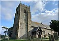
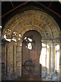
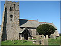
The church really is in a lovely location. Going through the lych gate, I was greeted by a mounting block with what looked like an old cross shaft on top, but which was a sundial. On the south wall of the tower there is a very interesting carved beam from the 15th century depicting a hunting scene and a green man.
In the churchyard there are some interesting grave markers. Mentioned in the church guide are 3 markers mentioning the children of the White family, who all died tragically young. The guide also mentions to look out for the mound on which the Norman castle was built.
 (PID:165811)")
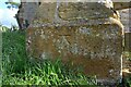
The All Saints guide booklet says that “before the present church was built it seems certain that there existed a church on or near the present site. An early deed talks of a monasterium (a small minster of secular priests). It is likely that this Saxon building (which stood in about the year 850) was of wood or wattle. Evidence that the site of the present church was a tenth century (about 950 AD) burial ground can be seen in the fragments of Anglo Danish (Viking) stones displayed in the tower.”
A collection of fragments is displayed on the north wall of the tower. A few (portable) pieces were too precious to leave on display, namely a medieval head and the carving of a 10th century Viking warrior, but these had been 3-D printed and samples left in the church.
The church guide says there are two pieces of hogback tombstone; these are “grave covers of the ‘Brompton’ (Northallerton) type with bears at either end. One gragment preserves it’s bear, as well as its central ridge and interlace carving. The second displays a monster with an elaborately knotted tail. Two fragments of standing cross shafts, one displaying a simple cross and plaitwork ….. the other with carved figures of Adam and Eve (the latter displayed as a photograph).
On the south wall of the tower there is a very interesting carved beam from the 15th century depicting a hunting scene and a green man.
Pickhill is a long, narrow village, and the church is towards the far side (coming from the A1/A6055) on Money Hill.
For more information see Pastscape 53926.
You may be viewing yesterday's version of this page. To see the most up to date information please register for a free account.
 (PID:165812)")
 (PID:165815)")
 (PID:165814)")
 (PID:165813)")
Do not use the above information on other web sites or publications without permission of the contributor.
Nearby Images from Geograph Britain and Ireland:
©2021(licence)
©2021(licence)
©2008(licence)
©2007(licence)
©2013(licence)
The above images may not be of the site on this page, they are loaded from Geograph.
Please Submit an Image of this site or go out and take one for us!
Click here to see more info for this site
Nearby sites
Key: Red: member's photo, Blue: 3rd party photo, Yellow: other image, Green: no photo - please go there and take one, Grey: site destroyed
Download sites to:
KML (Google Earth)
GPX (GPS waypoints)
CSV (Garmin/Navman)
CSV (Excel)
To unlock full downloads you need to sign up as a Contributory Member. Otherwise downloads are limited to 50 sites.
Turn off the page maps and other distractions
Nearby sites listing. In the following links * = Image available
208m WSW 254° Money Hill (Pickhill)* Artificial Mound (SE3451583693)
2.8km S 189° Sinderby* Henge (SE34288100)
3.4km SSW 196° Quernhow (Ainderby Quernhow) Cairn (SE33818045)
3.9km SW 233° Lady Well (Kirklington)* Holy Well or Sacred Spring (SE31628142)
7.0km SSW 199° St Mary (Wath)* Ancient Cross (SE32517715)
7.1km SW 235° Thornborough Cursus Cursus (SE289796)
7.5km SW 236° Thornborough Central* Henge (SE28517945)
7.6km SW 230° Thornborough S* Henge (SE28947884)
7.6km WSW 241° Thornborough N* Henge (SE28058005)
8.0km SW 235° Thornborough Cursus Cursus (SE282791)
8.0km WSW 258° St Michael's Church (Well)* Ancient Cross (SE2682982053)
8.6km WSW 257° St Michael's Well (Well)* Holy Well or Sacred Spring (SE26338175)
9.2km SSW 196° Nunwick Henge* Henge (SE3229274837)
9.3km WSW 238° St Nicholas (West Tanfield)* Ancient Cross (SE2679978746)
9.4km ESE 107° Pudding Pie Hill* Round Barrow(s) (SE437810)
9.4km WNW 301° St Gregory's Church (Bedale)* Early Christian Sculptured Stone (SE266885)
9.7km NE 54° St. Helen's Well (Borrowby) Holy Well or Sacred Spring (SE425895)
10.0km SW 215° Castle Dikes Hillfort (SE291755)
10.2km S 177° Hutton Moor* Henge (SE35267353)
10.6km NNE 11° All Saints (Northallerton)* Ancient Cross (SE36729420)
10.7km SE 145° Maiden's Bower (Asenby)* Turf Maze (SE409750)
11.0km SW 233° Ings Well (Mickley)* Holy Well or Sacred Spring (SE2593377125)
11.0km NE 52° St Mary (Leake)* Ancient Cross (SE43329063)
11.2km S 175° Copt Hewick Cursus Cursus (SE358726)
11.5km W 278° St Mary (Thornton Watlass)* Ancient Cross (SE2324585265)
View more nearby sites and additional images


 We would like to know more about this location. Please feel free to add a brief description and any relevant information in your own language.
 Wir möchten mehr über diese Stätte erfahren. Bitte zögern Sie nicht, eine kurze Beschreibung und relevante Informationen in Deutsch hinzuzufügen.
 Nous aimerions en savoir encore un peu sur les lieux. S'il vous plaît n'hesitez pas à ajouter une courte description et tous les renseignements pertinents dans votre propre langue.
 Quisieramos informarnos un poco más de las lugares. No dude en añadir una breve descripción y otros datos relevantes en su propio idioma.