


<< Our Photo Pages >> Round Hill Barrow - Round Barrow(s) in England in Derbyshire
Submitted by Infinite_Fate on Sunday, 01 January 2006 Page Views: 5696
Neolithic and Bronze AgeSite Name: Round Hill BarrowCountry: England
NOTE: This site is 0.7 km away from the location you searched for.
County: Derbyshire Type: Round Barrow(s)
Nearest Town: Derby Nearest Village: Barrow upon Trent
Map Ref: SK33342832
Latitude: 52.851352N Longitude: 1.506361W
Condition:
| 5 | Perfect |
| 4 | Almost Perfect |
| 3 | Reasonable but with some damage |
| 2 | Ruined but still recognisable as an ancient site |
| 1 | Pretty much destroyed, possibly visible as crop marks |
| 0 | No data. |
| -1 | Completely destroyed |
| 5 | Superb |
| 4 | Good |
| 3 | Ordinary |
| 2 | Not Good |
| 1 | Awful |
| 0 | No data. |
| 5 | Can be driven to, probably with disabled access |
| 4 | Short walk on a footpath |
| 3 | Requiring a bit more of a walk |
| 2 | A long walk |
| 1 | In the middle of nowhere, a nightmare to find |
| 0 | No data. |
| 5 | co-ordinates taken by GPS or official recorded co-ordinates |
| 4 | co-ordinates scaled from a detailed map |
| 3 | co-ordinates scaled from a bad map |
| 2 | co-ordinates of the nearest village |
| 1 | co-ordinates of the nearest town |
| 0 | no data |
Internal Links:
External Links:
I have visited· I would like to visit
elad13 would like to visit
")
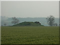
I've only viewed this from a hundred feet or so away as it's in the middle of a crop field and I didn't want to go wading through the farmer's livelihood. As a result all figures are pure guesswork! I'd say the mound itself was about 10 feet high with a diameter of 25 feet. It appears to still be perfectly (hemi-)spherical. I couldn't hazard a guess as to whether or not there was once a moat or ditch surrounding it.
In the otherwise level field it rises from the ground quite dramatically and is certainly worth taking a look at but with one proviso: access is not legal in the strictest sense of the word. There is a track passing through the field which is accessible from a gate on the A5132 but the gate is locked which suggests that one should keep out.
You may be viewing yesterday's version of this page. To see the most up to date information please register for a free account.
Do not use the above information on other web sites or publications without permission of the contributor.
Nearby Images from Geograph Britain and Ireland:
©2007(licence)
©2007(licence)
©2017(licence)
©2017(licence)
©2013(licence)
The above images may not be of the site on this page, they are loaded from Geograph.
Please Submit an Image of this site or go out and take one for us!
Click here to see more info for this site
Nearby sites
Key: Red: member's photo, Blue: 3rd party photo, Yellow: other image, Green: no photo - please go there and take one, Grey: site destroyed
Download sites to:
KML (Google Earth)
GPX (GPS waypoints)
CSV (Garmin/Navman)
CSV (Excel)
To unlock full downloads you need to sign up as a Contributory Member. Otherwise downloads are limited to 50 sites.
Turn off the page maps and other distractions
Nearby sites listing. In the following links * = Image available
1.2km SSE 153° Anchor Church* Cave or Rock Shelter (SK3390827236)
1.5km WNW 292° Findern Cursus Cursus (SK319289)
2.0km WNW 282° Findern Cursus Cursus (SK314287)
2.6km SSE 160° Heath Wood, Ingleby* Artificial Mound (SK34222591)
3.2km SSE 166° Hangman's Stone (Ingleby)* Marker Stone (SK34162524)
3.3km WSW 250° St Wystan's (Repton)* Early Christian Sculptured Stone (SK30292717)
3.4km ENE 70° Swarkestone Lows* Barrow Cemetery (SK365295)
3.7km WSW 252° St Thomas' Well (Repton) Holy Well or Sacred Spring (SK29822713)
4.1km WSW 252° St Ann's Well (Repton)* Holy Well or Sacred Spring (SK29442699)
5.6km ESE 112° Kings Newton Holy Well* Holy Well or Sacred Spring (SK38572629)
7.8km WNW 290° Etta's Well Holy Well or Sacred Spring (SK2631)
8.1km NNE 13° Derby Museum and Art Gallery* Museum (SK3509236220)
8.2km E 90° Aston Cursus Cursus (SK416284)
8.3km E 89° Aston Cursus Cursus (SK417285)
8.5km SE 138° Moated Mound at Breedon-on-the-Hill* Artificial Mound (SK3902822009)
8.7km NNE 11° Little Chester Roman Wells* Holy Well or Sacred Spring (SK350369)
8.8km SE 125° St Mary and St Hardulf (Breedon on the Hill)* Ancient Cross (SK4055723335)
8.8km SE 125° The Bulwarks (Breedon on the Hill)* Hillfort (SK406233)
8.9km NNE 12° Saint Alkmund's Well* Holy Well or Sacred Spring (SK35173703)
8.9km SSE 147° Staunton Harold's ancient village* Ancient Village or Settlement (SK3822120860)
9.4km E 80° Aston Cursus Cursus (SK426300)
9.4km NE 45° Saxon Holy Well* Holy Well or Sacred Spring (SK4035)
9.8km W 267° St Mary (Rolleston on Dove)* Ancient Cross (SK23542771)
9.9km SW 235° St Andrew's Well (Burton on Trent)* Holy Well or Sacred Spring (SK25212266)
10.0km NE 41° St Werburgh (Spondon)* Ancient Cross (SK39793592)
View more nearby sites and additional images


 We would like to know more about this location. Please feel free to add a brief description and any relevant information in your own language.
 Wir möchten mehr über diese Stätte erfahren. Bitte zögern Sie nicht, eine kurze Beschreibung und relevante Informationen in Deutsch hinzuzufügen.
 Nous aimerions en savoir encore un peu sur les lieux. S'il vous plaît n'hesitez pas à ajouter une courte description et tous les renseignements pertinents dans votre propre langue.
 Quisieramos informarnos un poco más de las lugares. No dude en añadir una breve descripción y otros datos relevantes en su propio idioma.