

<< Our Photo Pages >> Bevisbury - Hillfort in England in Hampshire
Submitted by JimChampion on Wednesday, 01 June 2005 Page Views: 8530
Iron Age and Later PrehistorySite Name: Bevisbury Alternative Name: Bevisbury CampCountry: England County: Hampshire Type: Hillfort
Nearest Village: Tangley
Map Ref: SU326541
Latitude: 51.285111N Longitude: 1.533938W
Condition:
| 5 | Perfect |
| 4 | Almost Perfect |
| 3 | Reasonable but with some damage |
| 2 | Ruined but still recognisable as an ancient site |
| 1 | Pretty much destroyed, possibly visible as crop marks |
| 0 | No data. |
| -1 | Completely destroyed |
| 5 | Superb |
| 4 | Good |
| 3 | Ordinary |
| 2 | Not Good |
| 1 | Awful |
| 0 | No data. |
| 5 | Can be driven to, probably with disabled access |
| 4 | Short walk on a footpath |
| 3 | Requiring a bit more of a walk |
| 2 | A long walk |
| 1 | In the middle of nowhere, a nightmare to find |
| 0 | No data. |
| 5 | co-ordinates taken by GPS or official recorded co-ordinates |
| 4 | co-ordinates scaled from a detailed map |
| 3 | co-ordinates scaled from a bad map |
| 2 | co-ordinates of the nearest village |
| 1 | co-ordinates of the nearest town |
| 0 | no data |
Be the first person to rate this site - see the 'Contribute!' box in the right hand menu.
Internal Links:
External Links:
")
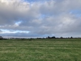
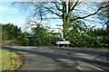
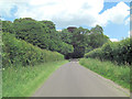
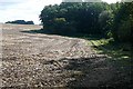
A small Iron Age camp with single bank and ditch. A modern road bisects the earthwork.
Have you visited this site? Please add any thoughts or comments below.
You may be viewing yesterday's version of this page. To see the most up to date information please register for a free account.
")
")
Do not use the above information on other web sites or publications without permission of the contributor.
coldrum has found this location on Google Street View:
Nearby Images from Geograph Britain and Ireland:
©2023(licence)
©2014(licence)
©2008(licence)
©2008(licence)
©2008(licence)
The above images may not be of the site on this page, they are loaded from Geograph.
Please Submit an Image of this site or go out and take one for us!
Click here to see more info for this site
Nearby sites
Key: Red: member's photo, Blue: 3rd party photo, Yellow: other image, Green: no photo - please go there and take one, Grey: site destroyed
Download sites to:
KML (Google Earth)
GPX (GPS waypoints)
CSV (Garmin/Navman)
CSV (Excel)
To unlock full downloads you need to sign up as a Contributory Member. Otherwise downloads are limited to 50 sites.
Turn off the page maps and other distractions
Nearby sites listing. In the following links * = Image available
2.2km N 355° Haydown Hill Field System* Misc. Earthwork (SU324563)
2.5km WNW 297° Kenward stone* Natural Stone / Erratic / Other Natural Feature (SU304552)
2.5km NNW 344° Fosbury Camp* Hillfort (SU319565)
4.1km ESE 117° Blagden Copse Bowl Barrow Round Barrow(s) (SU36305228)
4.3km WNW 295° Grim's Ditch 1 (Wiltshire) Misc. Earthwork (SU287559)
4.6km WNW 296° Chute 1 Long Barrow Long Barrow (SU28455609)
4.6km S 174° Nutbane* Long Barrow (SU33104952)
4.8km NW 317° Tidcombe Long Barrow* Long Barrow (SU2924957610)
5.3km NNW 343° Oxenwood Long Barrow* Long Barrow (SU3100059200)
5.8km WNW 293° Grafton 8 Bowl Barrow* Round Barrow(s) (SU27285636)
5.9km WNW 292° Grafton 9-11 Disc Barrows* Barrow Cemetery (SU271563)
6.0km NW 311° Tidcombe and Fosbury Mound Round Barrow(s) (SU2804957991)
6.3km W 262° Collingbourne Ducis 22 Bowl Barrow* Round Barrow(s) (SU26405317)
6.3km ESE 107° Severals Copse Bowl Barrow* Round Barrow(s) (SU38615227)
6.3km NW 306° Tow Barrow* Long Barrow (SU27425775)
6.6km NNW 332° Botley Hill Long Barrow* Long Barrow (SU2941859919)
6.7km NNW 332° Botley Hill Disc Barrow* Round Barrow(s) (SU2935660010)
6.9km WSW 245° Ludgershall Castle Southern Enclosure* Misc. Earthwork (SU2639051130)
6.9km S 175° Penton Park Bowl Barrow Round Barrow(s) (SU3326247217)
7.0km NNW 333° Botley Copse Bowl Barrow* Round Barrow(s) (SU2937060360)
7.2km NNW 345° Rivar Down Bowl Barrow* Round Barrow(s) (SU3073861020)
7.4km WNW 291° Collingbourne Kingston 21 Long Barrow* Long Barrow (SU25645671)
8.1km S 189° Wayhill Anglo-Norman Execution Cemetery* Barrow Cemetery (SU3140046100)
8.3km NNE 17° Inkpen Hill Barrows* Barrow Cemetery (SU34966203)
9.0km NNE 33° Walbury Camp* Hillfort (SU374617)
View more nearby sites and additional images


 We would like to know more about this location. Please feel free to add a brief description and any relevant information in your own language.
 Wir möchten mehr über diese Stätte erfahren. Bitte zögern Sie nicht, eine kurze Beschreibung und relevante Informationen in Deutsch hinzuzufügen.
 Nous aimerions en savoir encore un peu sur les lieux. S'il vous plaît n'hesitez pas à ajouter une courte description et tous les renseignements pertinents dans votre propre langue.
 Quisieramos informarnos un poco más de las lugares. No dude en añadir una breve descripción y otros datos relevantes en su propio idioma.