
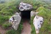

<< Our Photo Pages >> Ascott under Wychwood - Chambered Tomb in England in Oxfordshire
Submitted by vicky on Tuesday, 24 September 2002 Page Views: 17699
Neolithic and Bronze AgeSite Name: Ascott under WychwoodCountry: England County: Oxfordshire Type: Chambered Tomb
Map Ref: SP299176 Landranger Map Number: 164
Latitude: 51.856193N Longitude: 1.567268W
Condition:
| 5 | Perfect |
| 4 | Almost Perfect |
| 3 | Reasonable but with some damage |
| 2 | Ruined but still recognisable as an ancient site |
| 1 | Pretty much destroyed, possibly visible as crop marks |
| 0 | No data. |
| -1 | Completely destroyed |
| 5 | Superb |
| 4 | Good |
| 3 | Ordinary |
| 2 | Not Good |
| 1 | Awful |
| 0 | No data. |
| 5 | Can be driven to, probably with disabled access |
| 4 | Short walk on a footpath |
| 3 | Requiring a bit more of a walk |
| 2 | A long walk |
| 1 | In the middle of nowhere, a nightmare to find |
| 0 | No data. |
| 5 | co-ordinates taken by GPS or official recorded co-ordinates |
| 4 | co-ordinates scaled from a detailed map |
| 3 | co-ordinates scaled from a bad map |
| 2 | co-ordinates of the nearest village |
| 1 | co-ordinates of the nearest town |
| 0 | no data |
Internal Links:
External Links:
I have visited· I would like to visit
h_fenton Andy B have visited here
")
Have you visited this site? Please add a comment below.
You may be viewing yesterday's version of this page. To see the most up to date information please register for a free account.
")
")
Do not use the above information on other web sites or publications without permission of the contributor.
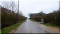
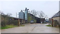
Nearby Images from Geograph Britain and Ireland:
©2006(licence)
©2008(licence)
©2006(licence)
©2015(licence)
©2015(licence)
The above images may not be of the site on this page, they are loaded from Geograph.
Please Submit an Image of this site or go out and take one for us!
Click here to see more info for this site
Nearby sites
Key: Red: member's photo, Blue: 3rd party photo, Yellow: other image, Green: no photo - please go there and take one, Grey: site destroyed
Download sites to:
KML (Google Earth)
GPX (GPS waypoints)
CSV (Garmin/Navman)
CSV (Excel)
To unlock full downloads you need to sign up as a Contributory Member. Otherwise downloads are limited to 50 sites.
Turn off the page maps and other distractions
Nearby sites listing. In the following links * = Image available
212m SW 225° Coldwell Bridge Long Barrow 2* Long Barrow (SP29751745)
1.8km ENE 59° Smallstones Farm Long Barrow (SP31411852)
1.9km E 93° High Lodge Tumuli Round Barrow(s) (SP318175)
3.2km ESE 111° Slatepits Copse* Chambered Tomb (SP329165)
3.3km ESE 103° Churchill Copse* Long Barrow (SP33161685)
3.5km N 358° Lyneham Long Barrow* Long Barrow (SP29752107)
3.7km SW 235° Shipton Barrow* Barrow Cemetery (SP269155)
3.7km S 190° Ladihame* Long Barrow (SP293139)
3.8km N 0° Lyneham Camp* Hillfort (SP299214)
5.5km N 351° Old Vicarage* Standing Stone (Menhir) (SP290230)
5.5km ENE 78° Cornbury Park Round Barrow(s) (SP35311878)
5.7km NNE 18° Knollbury Enclosure* Ancient Village or Settlement (SP3160023000)
6.3km ENE 78° Sturt Henge* Modern Stone Circle etc (SP36111899)
6.7km NNW 347° Churchill* Stone Circle (SP284241)
7.2km NE 34° Hawk Stone* Standing Stone (Menhir) (SP3392023540)
7.3km WNW 286° Idbury Camp* Hillfort (SP22871954)
7.4km SSE 149° Churchill Plain Chambered Tomb (SP33711129)
7.4km NE 55° Thorsbrook Spring* Holy Well or Sacred Spring (SP360219)
7.5km NE 54° Thor Stone* Standing Stone (Menhir) (SP35932208)
7.6km S 188° Asthall Barrow* Barrow Cemetery (SP289101)
8.0km ESE 111° The Lady's Well (Oxfordshire)* Holy Well or Sacred Spring (SP374148)
8.1km N 357° Churchill Standing Stone* Standing Stone (Menhir) (SP29372568)
8.2km W 279° Fifield Chambered Cairn (SP218188)
9.0km ENE 69° Model Farm Ancient Village or Settlement (SP383209)
9.5km N 7° Serpent's Well (Chipping Norton) Holy Well or Sacred Spring (SP310270)
View more nearby sites and additional images


 We would like to know more about this location. Please feel free to add a brief description and any relevant information in your own language.
 Wir möchten mehr über diese Stätte erfahren. Bitte zögern Sie nicht, eine kurze Beschreibung und relevante Informationen in Deutsch hinzuzufügen.
 Nous aimerions en savoir encore un peu sur les lieux. S'il vous plaît n'hesitez pas à ajouter une courte description et tous les renseignements pertinents dans votre propre langue.
 Quisieramos informarnos un poco más de las lugares. No dude en añadir una breve descripción y otros datos relevantes en su propio idioma.