<< Text Pages >> Gray Stone (Burley) - Natural Stone / Erratic / Other Natural Feature in England in Yorkshire (West)
Submitted by Anne T on Tuesday, 31 October 2017 Page Views: 2634
Natural PlacesSite Name: Gray Stone (Burley) Alternative Name: Giant's Stone (Burley)Country: England
NOTE: This site is 1.7 km away from the location you searched for.
County: Yorkshire (West) Type: Natural Stone / Erratic / Other Natural Feature
Nearest Town: Leeds Nearest Village: Burley
Map Ref: SE2865934229
Latitude: 53.803575N Longitude: 1.566328W
Condition:
| 5 | Perfect |
| 4 | Almost Perfect |
| 3 | Reasonable but with some damage |
| 2 | Ruined but still recognisable as an ancient site |
| 1 | Pretty much destroyed, possibly visible as crop marks |
| 0 | No data. |
| -1 | Completely destroyed |
| 5 | Superb |
| 4 | Good |
| 3 | Ordinary |
| 2 | Not Good |
| 1 | Awful |
| 0 | No data. |
| 5 | Can be driven to, probably with disabled access |
| 4 | Short walk on a footpath |
| 3 | Requiring a bit more of a walk |
| 2 | A long walk |
| 1 | In the middle of nowhere, a nightmare to find |
| 0 | No data. |
| 5 | co-ordinates taken by GPS or official recorded co-ordinates |
| 4 | co-ordinates scaled from a detailed map |
| 3 | co-ordinates scaled from a bad map |
| 2 | co-ordinates of the nearest village |
| 1 | co-ordinates of the nearest town |
| 0 | no data |
Be the first person to rate this site - see the 'Contribute!' box in the right hand menu.
Internal Links:
External Links:
I have visited· I would like to visit
histon would like to visit
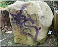
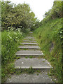
The Northern Antiquarian (TNA) tell us this now vandalised stone was originally located at SE 28449 34364, but is now to be found "halfway along Westfield Road, where it meets up with Hollis Place, along the footpath at the back of the school, set back against the walling. A plaque by the rock kinda gives the game away!"
Also known as the Giant's Stone, for more information see TNA's page for Gray Stone, Burley, Leeds, West Yorkshire, which gives directions for finding this legendary stone together with the location of the stone shown on the 1852 OS map, a brief archaeology & history and local folklore.
TNA add that the original Gray Stone may have been a standing stone, but we cannot be certain about this.
Note: Have you visited this site? Do you have any photographs or information to add?
You may be viewing yesterday's version of this page. To see the most up to date information please register for a free account.
Do not use the above information on other web sites or publications without permission of the contributor.
Nearby Images from Geograph Britain and Ireland:
©2007(licence)

©2025(licence)
©2019(licence)

©2025(licence)

©2025(licence)
The above images may not be of the site on this page, they are loaded from Geograph.
Please Submit an Image of this site or go out and take one for us!
Click here to see more info for this site
Nearby sites
Key: Red: member's photo, Blue: 3rd party photo, Yellow: other image, Green: no photo - please go there and take one, Grey: site destroyed
Download sites to:
KML (Google Earth)
GPX (GPS waypoints)
CSV (Garmin/Navman)
CSV (Excel)
To unlock full downloads you need to sign up as a Contributory Member. Otherwise downloads are limited to 50 sites.
Turn off the page maps and other distractions
Nearby sites listing. In the following links * = Image available
1.3km E 99° Leeds City Museum* Museum (SE2993634036)
1.6km SSE 148° St Helen's Well (Holbeck) Holy Well or Sacred Spring (SE295329)
2.0km ESE 105° Lady Well (Leeds) Holy Well or Sacred Spring (SE30603373)
2.2km ESE 115° St Peter's Minster Church (Kirkgate) Ancient Cross (SE30653330)
2.3km ESE 106° Quarry Hill (Leeds) Ancient Village or Settlement (SE309336)
4.7km ENE 59° Gipton Wood Ancient Village or Settlement (SE32653664)
6.1km NNW 348° Adel Cupstone* Rock Art (SE274402)
6.2km WNW 302° Horsforth Milestone* Rock Art (SE23323748)
7.6km NNW 328° Gab Wood (2)* Carving (SE2460640625)
7.9km NNW 333° Long Stone (Adel) Standing Stone (Menhir) (SE25014119)
8.1km ENE 62° Grim's Dyke* Misc. Earthwork (SE358380)
8.4km WNW 291° St Wilfrid (Calverley) Sculptured Stone (SE208372)
9.1km WNW 295° Calverley Woods 2 (Leeds) Rock Art (SE2037737939)
9.1km WNW 294° Calverley Woods 3 (Leeds)* Rock Art (SE2036937923)
9.1km WNW 288° Calverley Woods Stone Circle (Leeds) Stone Circle (SE200370)
9.3km NNE 18° Grey Stone (Harewood)* Rock Art (SE31474308)
9.3km WNW 294° Calverley Woods 1 (Leeds) Rock Art (SE20083791)
9.4km WNW 289° West Woods 1 (Calverley) Rock Art (SE19703731)
9.6km WNW 289° West Woods 2 (Calverley) Rock Art (SE195373)
10.0km WNW 282° Holy Well (Eccleshill) Holy Well or Sacred Spring (SE18783622)
10.4km SW 221° Pickel Well (Birstall) Holy Well or Sacred Spring (SE21802633)
10.9km SW 227° Moor Lane Well (Gomersal) Holy Well or Sacred Spring (SE20712677)
11.6km ENE 74° Barwick in Elmet Hillfort* Hillfort (SE398375)
11.8km SW 220° Mannerly Well (Gomersal) Holy Well or Sacred Spring (SE21072515)
11.9km NE 42° All Hallows (Bardsey)* Ancient Cross (SE3656143122)
View more nearby sites and additional images


 We would like to know more about this location. Please feel free to add a brief description and any relevant information in your own language.
 Wir möchten mehr über diese Stätte erfahren. Bitte zögern Sie nicht, eine kurze Beschreibung und relevante Informationen in Deutsch hinzuzufügen.
 Nous aimerions en savoir encore un peu sur les lieux. S'il vous plaît n'hesitez pas à ajouter une courte description et tous les renseignements pertinents dans votre propre langue.
 Quisieramos informarnos un poco más de las lugares. No dude en añadir una breve descripción y otros datos relevantes en su propio idioma.