<< Our Photo Pages >> Morwick 1f - Rock Art in England in Northumberland
Submitted by SolarMegalith on Friday, 14 March 2014 Page Views: 1868
Rock ArtSite Name: Morwick 1f Alternative Name: ERA-609; Beckensall 769; NMR 8059; SAM 24698; SMR/HER N5558Country: England County: Northumberland Type: Rock Art
Nearest Town: Warkworth Nearest Village: Morwick Hall
Map Ref: NU2330004418
Latitude: 55.333266N Longitude: 1.634266W
Condition:
| 5 | Perfect |
| 4 | Almost Perfect |
| 3 | Reasonable but with some damage |
| 2 | Ruined but still recognisable as an ancient site |
| 1 | Pretty much destroyed, possibly visible as crop marks |
| 0 | No data. |
| -1 | Completely destroyed |
| 5 | Superb |
| 4 | Good |
| 3 | Ordinary |
| 2 | Not Good |
| 1 | Awful |
| 0 | No data. |
| 5 | Can be driven to, probably with disabled access |
| 4 | Short walk on a footpath |
| 3 | Requiring a bit more of a walk |
| 2 | A long walk |
| 1 | In the middle of nowhere, a nightmare to find |
| 0 | No data. |
| 5 | co-ordinates taken by GPS or official recorded co-ordinates |
| 4 | co-ordinates scaled from a detailed map |
| 3 | co-ordinates scaled from a bad map |
| 2 | co-ordinates of the nearest village |
| 1 | co-ordinates of the nearest town |
| 0 | no data |
Internal Links:
External Links:
I have visited· I would like to visit
SolarMegalith visited on 10th Mar 2014 - their rating: Cond: 4 Amb: 5 Access: 3
")
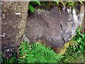
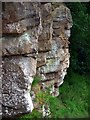
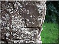
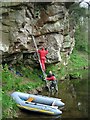
Three spiral motifs are located on an overhang about 2m over the water level. Few concentric carvings can be seen to the south, but these are covered with lichen and difficult to observe from the footpath.
For more information see England's Rock Art entry for ERA-609 Morwick 1f, which includes both NADRAP's and Beckensall's descriptions, Beckensall's Archive notes, photographs, a sketch of the rock and its motifs, plus photogrammetry and media from the Beckensall Archive.
The original Beckensall record can be found at Internet Archive: Beckensall 769 Morwick 1f.
This rock art panel is located on Open Access land. [note: Beckensall recorded 'Access by Right of Way'.]
You may be viewing yesterday's version of this page. To see the most up to date information please register for a free account.
")
Do not use the above information on other web sites or publications without permission of the contributor.
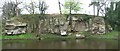
Nearby Images from Geograph Britain and Ireland:
©2011(licence)
©2009(licence)
©2011(licence)
©2011(licence)
©2020(licence)
The above images may not be of the site on this page, they are loaded from Geograph.
Please Submit an Image of this site or go out and take one for us!
Click here to see more info for this site
Nearby sites
Key: Red: member's photo, Blue: 3rd party photo, Yellow: other image, Green: no photo - please go there and take one, Grey: site destroyed
Download sites to:
KML (Google Earth)
GPX (GPS waypoints)
CSV (Garmin/Navman)
CSV (Excel)
To unlock full downloads you need to sign up as a Contributory Member. Otherwise downloads are limited to 50 sites.
Turn off the page maps and other distractions
Nearby sites listing. In the following links * = Image available
1m NNE 31° Morwick N01 Rock Art (NU2330004419)
2m N 0° Morwick 1d & 1e* Rock Art (NU2330004420)
4m ENE 76° Morwick 1g Rock Art (NU2330404419)
6m ENE 72° Morwick 1c Rock Art (NU2330604420)
8m NE 50° Morwick* Rock Art (NU2330604423)
8m E 83° Morwick 1b* Rock Art (NU2330804419)
8m ENE 76° Morwick 1a* Rock Art (NU2330804420)
14m W 266° Morwick 2d* Rock Art (NU2328604417)
14m W 262° Morwick 2a* Rock Art (NU2328604416)
14m WSW 258° Morwick 2b & 2c* Rock Art (NU2328604415)
20m W 262° Morwick 2e & 2g Rock Art (NU2328004415)
20m W 259° Morwick 2f* Rock Art (NU2328004414)
4.0km E 84° Amble Pier Cist* Cist (NU27280484)
4.4km E 92° Amble Quarry Cists* Cist (NU277043)
5.7km ESE 118° Low Hauxley* Cairn (NU284018)
6.7km NNE 14° Alnmouth Wall Rock 33 Rock Art (NU2485610982)
6.7km NNE 14° Alnmouth Wall Rock 32* Rock Art (NU2485610992)
6.7km NNE 14° Alnmouth Wall Rock 38* Rock Art (NU2487910987)
6.8km NNE 14° Alnmouth Wall Rock 34* Rock Art (NU2487110990)
6.8km NNE 14° Alnmouth Wall Rock 35* Rock Art (NU2487510991)
6.8km NNE 13° Alnmouth Wall Rock 28 & 29 Rock Art (NU2484210999)
6.8km NNE 14° Alnmouth Wall Rock 37* Rock Art (NU2487610991)
6.8km NNE 13° Alnmouth Wall Rock 8 Rock Art (NU2478311013)
6.8km NNE 14° Alnmouth Wall Rock 36* Rock Art (NU2487410992)
6.8km NNE 14° Alnmouth Wall Rock 30 & 31 Rock Art (NU2484911000)
View more nearby sites and additional images


 We would like to know more about this location. Please feel free to add a brief description and any relevant information in your own language.
 Wir möchten mehr über diese Stätte erfahren. Bitte zögern Sie nicht, eine kurze Beschreibung und relevante Informationen in Deutsch hinzuzufügen.
 Nous aimerions en savoir encore un peu sur les lieux. S'il vous plaît n'hesitez pas à ajouter une courte description et tous les renseignements pertinents dans votre propre langue.
 Quisieramos informarnos un poco más de las lugares. No dude en añadir una breve descripción y otros datos relevantes en su propio idioma.