<< Our Photo Pages >> Lugden Barrow - Round Barrow(s) in England in Hampshire
Submitted by JimChampion on Monday, 23 July 2007 Page Views: 6783
Neolithic and Bronze AgeSite Name: Lugden BarrowCountry: England
NOTE: This site is 1.9 km away from the location you searched for.
County: Hampshire Type: Round Barrow(s)
Nearest Town: Ringwood Nearest Village: Burley
Map Ref: SU18920091
Latitude: 50.807439N Longitude: 1.732853W
Condition:
| 5 | Perfect |
| 4 | Almost Perfect |
| 3 | Reasonable but with some damage |
| 2 | Ruined but still recognisable as an ancient site |
| 1 | Pretty much destroyed, possibly visible as crop marks |
| 0 | No data. |
| -1 | Completely destroyed |
| 5 | Superb |
| 4 | Good |
| 3 | Ordinary |
| 2 | Not Good |
| 1 | Awful |
| 0 | No data. |
| 5 | Can be driven to, probably with disabled access |
| 4 | Short walk on a footpath |
| 3 | Requiring a bit more of a walk |
| 2 | A long walk |
| 1 | In the middle of nowhere, a nightmare to find |
| 0 | No data. |
| 5 | co-ordinates taken by GPS or official recorded co-ordinates |
| 4 | co-ordinates scaled from a detailed map |
| 3 | co-ordinates scaled from a bad map |
| 2 | co-ordinates of the nearest village |
| 1 | co-ordinates of the nearest town |
| 0 | no data |
Internal Links:
External Links:
I have visited· I would like to visit
JimChampion has visited here
")
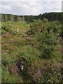
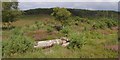
The parish boundary between Ringwood (to the west) and Burley (to the east) follows a straight line between the Knaves Ash barrow and this site, Lugden Barrow. It is a good example of prehistoric mounds being used to define more modern boundaries - and here the boundary crosses the 'wasteland' of heath and bog, part of which is now recognised as a National Nature Reserve. To the west there is another barrow on the Ringwood/Sopley parish boundary, at grid reference SU18170071.
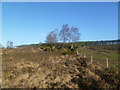
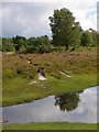
The Hampshire Treasures online resource describes this barrow as "A vague mound 13.0 m in diameter and 0.4 m high." [source]
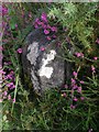
The barrow mound has a small boundary stone set into it (inscribed with an upwards-pointing arrow).
Access The site is easy to locate, being at the only bend in the western boundary fence of the Dur Hill Inclosure. Use an OS map, but bear in mind that the description "a vague mound" is entirely accurate.
You may be viewing yesterday's version of this page. To see the most up to date information please register for a free account.
")
")
")
Do not use the above information on other web sites or publications without permission of the contributor.
Nearby Images from Geograph Britain and Ireland:
©2007(licence)
©2007(licence)
©2011(licence)
©2007(licence)
©2007(licence)
The above images may not be of the site on this page, they are loaded from Geograph.
Please Submit an Image of this site or go out and take one for us!
Click here to see more info for this site
Nearby sites
Key: Red: member's photo, Blue: 3rd party photo, Yellow: other image, Green: no photo - please go there and take one, Grey: site destroyed
Download sites to:
KML (Google Earth)
GPX (GPS waypoints)
CSV (Garmin/Navman)
CSV (Excel)
To unlock full downloads you need to sign up as a Contributory Member. Otherwise downloads are limited to 50 sites.
Turn off the page maps and other distractions
Nearby sites listing. In the following links * = Image available
1.4km SSE 147° All Saints Well* Holy Well or Sacred Spring (SZ197997)
2.8km N 0° Strodgemoor Barrow* Round Barrow(s) (SU18910371)
3.1km N 351° Knaves Ash barrow* Round Barrow(s) (SU18430396)
3.1km NNE 18° Castle Hill (Hampshire)* Hillfort (SU199039)
3.7km NNE 27° St Mary's Well (Hampshire)* Holy Well or Sacred Spring (SU2056304175)
4.4km NNE 33° Collins Grave Round Barrow(s) (SU21350461)
4.9km ENE 69° Clay Hill tumuli* Round Barrow(s) (SU235027)
5.1km SW 218° St Michael's Well (Sopley)* Holy Well or Sacred Spring (SZ1573596865)
6.3km W 280° Barnsfield Heath (North)* Round Barrow(s) (SU127020)
6.8km WSW 257° Hurn Forest Barrow* Round Barrow(s) (SZ123993)
6.8km WSW 237° Sopley Common Tumulus* Round Barrow(s) (SZ132972)
7.0km ENE 71° Ferny Knap tumuli* Round Barrow(s) (SU255032)
7.0km SW 235° Ramsdown Plantation / Sopley Common* Round Barrow(s) (SZ132969)
7.1km SW 221° St Catherine's Hill (Christchurch)* Barrow Cemetery (SZ143955)
7.3km NW 308° Watchmoor Wood* Round Barrow(s) (SU131054)
7.8km NW 308° Ashley Heath* Round Barrow(s) (SU128057)
7.8km NNW 342° Moyles Court bowl barrow* Round Barrow(s) (SU16510833)
7.9km NW 310° Bakers Hanging* Round Barrow(s) (SU128060)
8.0km N 7° Castle Piece* Hillfort (SU199089)
8.1km S 178° Friars Cliff Tumulus* Round Barrow(s) (SZ1917492825)
8.9km SSW 200° The Red House Museum* Museum (SZ1588292577)
8.9km E 97° Longslade View tumulus* Round Barrow(s) (SZ278998)
9.1km WNW 289° Lions Hill Enclosure* Misc. Earthwork (SU103039)
9.3km NNW 346° South Gorley Bowl Barrow Round Barrow(s) (SU16640997)
9.4km W 269° Trickett's Cross Barrow* Round Barrow(s) (SU095007)
View more nearby sites and additional images


 We would like to know more about this location. Please feel free to add a brief description and any relevant information in your own language.
 Wir möchten mehr über diese Stätte erfahren. Bitte zögern Sie nicht, eine kurze Beschreibung und relevante Informationen in Deutsch hinzuzufügen.
 Nous aimerions en savoir encore un peu sur les lieux. S'il vous plaît n'hesitez pas à ajouter une courte description et tous les renseignements pertinents dans votre propre langue.
 Quisieramos informarnos un poco más de las lugares. No dude en añadir una breve descripción y otros datos relevantes en su propio idioma.