<< Our Photo Pages >> Breamore Miz-Maze - Turf Maze in England in Hampshire
Submitted by Gerald_Ponting on Thursday, 28 June 2001 Page Views: 38593
Multi-periodSite Name: Breamore Miz-Maze Alternative Name: Miz MazeCountry: England County: Hampshire Type: Turf Maze
Nearest Town: Fordingbridge Nearest Village: Breamore
Map Ref: SU1412520266
Latitude: 50.981630N Longitude: 1.800161W
Condition:
| 5 | Perfect |
| 4 | Almost Perfect |
| 3 | Reasonable but with some damage |
| 2 | Ruined but still recognisable as an ancient site |
| 1 | Pretty much destroyed, possibly visible as crop marks |
| 0 | No data. |
| -1 | Completely destroyed |
| 5 | Superb |
| 4 | Good |
| 3 | Ordinary |
| 2 | Not Good |
| 1 | Awful |
| 0 | No data. |
| 5 | Can be driven to, probably with disabled access |
| 4 | Short walk on a footpath |
| 3 | Requiring a bit more of a walk |
| 2 | A long walk |
| 1 | In the middle of nowhere, a nightmare to find |
| 0 | No data. |
| 5 | co-ordinates taken by GPS or official recorded co-ordinates |
| 4 | co-ordinates scaled from a detailed map |
| 3 | co-ordinates scaled from a bad map |
| 2 | co-ordinates of the nearest village |
| 1 | co-ordinates of the nearest town |
| 0 | no data |
Internal Links:
External Links:
I have visited· I would like to visit
theaksy visited on 27th Aug 2021 - their rating: Cond: 5 Amb: 4 Access: 4
weeblewobble visited on 1st Jan 2009 - their rating: Cond: 4 Amb: 4 Access: 2
JimChampion have visited here
Average ratings for this site from all visit loggers: Condition: 4.5 Ambience: 4 Access: 3
")
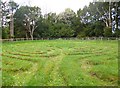
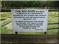
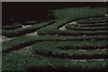
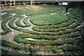
It is a scheduled ancient monument and fenced off, thus being impossible to walk upon. However, if you could the maze follows the raised grass paths - using it would wear it out! The mizmaze on St Catherine's Hill is a more sensible design, in that you walk in the cut paths, wearing the impression of the maze deeper into the soil.
Access Leave your vehicle at the Breamore House and Museum car park which is clearly signposted from the A338. On foot, follow the signs to Breamore House (no need to buy a ticket) and follow the bridlepath past the house and all the way through Breamore Wood and keep going. A large sign indicates the final turn you need to take to reach the miz-maze. The Giant's Grave long barrow is less than 500 metres SW of the mizmaze and is worth a look if you've come this far.
Note: Breamore is pronounced 'Bremmer' locally... useful info if you need to ask for directions.
You may be viewing yesterday's version of this page. To see the most up to date information please register for a free account.
")
Do not use the above information on other web sites or publications without permission of the contributor.
Nearby Images from Geograph Britain and Ireland:
©2013(licence)

©2024(licence)
©2021(licence)
©2012(licence)
©2007(licence)
The above images may not be of the site on this page, they are loaded from Geograph.
Please Submit an Image of this site or go out and take one for us!
Click here to see more info for this site
Nearby sites
Key: Red: member's photo, Blue: 3rd party photo, Yellow: other image, Green: no photo - please go there and take one, Grey: site destroyed
Download sites to:
KML (Google Earth)
GPX (GPS waypoints)
CSV (Garmin/Navman)
CSV (Excel)
To unlock full downloads you need to sign up as a Contributory Member. Otherwise downloads are limited to 50 sites.
Turn off the page maps and other distractions
Nearby sites listing. In the following links * = Image available
419m SW 231° Giants Grave (Breamore)* Long Barrow (SU138200)
1.2km NNW 334° Gallows Hill (Downton) Round Barrow(s) (SU13592136)
1.6km WSW 245° Whitsbury* Hillfort (SU127196)
2.6km NW 312° Whitsbury Down* Long Barrow (SU12212200)
3.2km NE 41° Giant's Chair (Downton)* Round Barrow(s) (SU1627422705)
3.4km NE 36° Giant's Grave (Downton)* Long Barrow (SU16102300)
3.6km W 272° Duck's Nest* Long Barrow (SU105204)
3.8km NW 310° Round Clump* Long Barrow (SU112227)
4.3km NNE 15° Clearbury Ring* Hillfort (SU152244)
4.4km WNW 296° Tenantry Farm* Long Barrow (SU10162219)
4.6km WSW 247° Damerham Knoll Camp* Hillfort (SU099185)
5.0km WNW 296° Grims Lodge Barrow* Long Barrow (SU0957722440)
5.1km W 266° Knap Barrow* Long Barrow (SU090199)
5.1km W 265° Grans Barrow* Long Barrow (SU090198)
5.3km WSW 253° Knoll Down Tumulus* Round Barrow(s) (SU0908418750)
5.4km WSW 258° Knoll Down tumuli* Round Barrow(s) (SU088191)
5.7km SSE 153° Frankenbury* Hillfort (SU167152)
6.3km ENE 75° Templeman's Tumulus* Artificial Mound (SU202219)
6.3km WSW 245° Soldiers Ring (Dorset)* Misc. Earthwork (SU084176)
6.4km WNW 285° Furze Down Long Barrow (SU0791621895)
7.2km SW 227° Damerham Ceremonial Complex* Long Barrow (SU08841534)
7.5km ESE 108° Jacob's Barrow* Round Barrow(s) (SU21321793)
7.7km W 273° Longbarrow House* Long Barrow (SU064206)
8.0km N 6° Rowbarrow Salisbury* Misc. Earthwork (SU14902820)
8.0km WSW 254° Tidpit Common Down Long Barrow (SU064181)
View more nearby sites and additional images


 We would like to know more about this location. Please feel free to add a brief description and any relevant information in your own language.
 Wir möchten mehr über diese Stätte erfahren. Bitte zögern Sie nicht, eine kurze Beschreibung und relevante Informationen in Deutsch hinzuzufügen.
 Nous aimerions en savoir encore un peu sur les lieux. S'il vous plaît n'hesitez pas à ajouter une courte description et tous les renseignements pertinents dans votre propre langue.
 Quisieramos informarnos un poco más de las lugares. No dude en añadir una breve descripción y otros datos relevantes en su propio idioma.