<< Our Photo Pages >> Giants Grave (Breamore) - Long Barrow in England in Hampshire
Submitted by JimChampion on Sunday, 08 May 2005 Page Views: 14705
Neolithic and Bronze AgeSite Name: Giants Grave (Breamore)Country: England County: Hampshire Type: Long Barrow
Nearest Town: Fordingbridge Nearest Village: Breamore
Map Ref: SU138200
Latitude: 50.979246N Longitude: 1.8048W
Condition:
| 5 | Perfect |
| 4 | Almost Perfect |
| 3 | Reasonable but with some damage |
| 2 | Ruined but still recognisable as an ancient site |
| 1 | Pretty much destroyed, possibly visible as crop marks |
| 0 | No data. |
| -1 | Completely destroyed |
| 5 | Superb |
| 4 | Good |
| 3 | Ordinary |
| 2 | Not Good |
| 1 | Awful |
| 0 | No data. |
| 5 | Can be driven to, probably with disabled access |
| 4 | Short walk on a footpath |
| 3 | Requiring a bit more of a walk |
| 2 | A long walk |
| 1 | In the middle of nowhere, a nightmare to find |
| 0 | No data. |
| 5 | co-ordinates taken by GPS or official recorded co-ordinates |
| 4 | co-ordinates scaled from a detailed map |
| 3 | co-ordinates scaled from a bad map |
| 2 | co-ordinates of the nearest village |
| 1 | co-ordinates of the nearest town |
| 0 | no data |
Internal Links:
External Links:
I have visited· I would like to visit
theaksy saw from a distance on 27th Aug 2021 - their rating: Cond: 4 Amb: 4 Access: 4
JimChampion have visited here
 (PID:14351)")
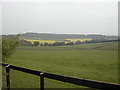
A neolithic long barrow, oriented NE-SW, originally 65m long and 26m wide with flanked ditches. Now partly mutilated at its SW end and no trace of ditches due to ploughing. The barrow's axis points uphill, which contrasts with most of the other local long barrows which follow the local contours. [source]
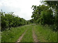
Access The barrow is in the care of the Breamore House estate, and it now has a rabbit-proof perimeter fence and sign. This part of the estate can be visited for free, and access paths have been made through the crops. The barrow is a short distance southwest of the Breamore Miz-Maze: see that site's entry for detailed directions.
You may be viewing yesterday's version of this page. To see the most up to date information please register for a free account.
Do not use the above information on other web sites or publications without permission of the contributor.
Nearby Images from Geograph Britain and Ireland:

©2005(licence)
©2007(licence)
©2008(licence)
©2008(licence)
©2010(licence)
The above images may not be of the site on this page, they are loaded from Geograph.
Please Submit an Image of this site or go out and take one for us!
Click here to see more info for this site
Nearby sites
Key: Red: member's photo, Blue: 3rd party photo, Yellow: other image, Green: no photo - please go there and take one, Grey: site destroyed
Download sites to:
KML (Google Earth)
GPX (GPS waypoints)
CSV (Garmin/Navman)
CSV (Excel)
To unlock full downloads you need to sign up as a Contributory Member. Otherwise downloads are limited to 50 sites.
Turn off the page maps and other distractions
Nearby sites listing. In the following links * = Image available
419m NE 51° Breamore Miz-Maze* Turf Maze (SU1412520266)
1.2km WSW 250° Whitsbury* Hillfort (SU127196)
1.4km N 351° Gallows Hill (Downton) Round Barrow(s) (SU13592136)
2.6km NW 322° Whitsbury Down* Long Barrow (SU12212200)
3.3km W 277° Duck's Nest* Long Barrow (SU105204)
3.7km NE 43° Giant's Chair (Downton)* Round Barrow(s) (SU1627422705)
3.7km NW 316° Round Clump* Long Barrow (SU112227)
3.8km NE 38° Giant's Grave (Downton)* Long Barrow (SU16102300)
4.2km WSW 249° Damerham Knoll Camp* Hillfort (SU099185)
4.2km WNW 301° Tenantry Farm* Long Barrow (SU10162219)
4.6km NNE 18° Clearbury Ring* Hillfort (SU152244)
4.8km W 269° Knap Barrow* Long Barrow (SU090199)
4.8km W 268° Grans Barrow* Long Barrow (SU090198)
4.9km WSW 255° Knoll Down Tumulus* Round Barrow(s) (SU0908418750)
4.9km WNW 300° Grims Lodge Barrow* Long Barrow (SU0957722440)
5.1km W 260° Knoll Down tumuli* Round Barrow(s) (SU088191)
5.6km SSE 149° Frankenbury* Hillfort (SU167152)
5.9km WSW 246° Soldiers Ring (Dorset)* Misc. Earthwork (SU084176)
6.2km WNW 288° Furze Down Long Barrow (SU0791621895)
6.7km ENE 74° Templeman's Tumulus* Artificial Mound (SU202219)
6.8km SW 227° Damerham Ceremonial Complex* Long Barrow (SU08841534)
7.4km W 275° Longbarrow House* Long Barrow (SU064206)
7.6km WSW 256° Tidpit Common Down Long Barrow (SU064181)
7.8km ESE 106° Jacob's Barrow* Round Barrow(s) (SU21321793)
8.3km N 8° Rowbarrow Salisbury* Misc. Earthwork (SU14902820)
View more nearby sites and additional images


 We would like to know more about this location. Please feel free to add a brief description and any relevant information in your own language.
 Wir möchten mehr über diese Stätte erfahren. Bitte zögern Sie nicht, eine kurze Beschreibung und relevante Informationen in Deutsch hinzuzufügen.
 Nous aimerions en savoir encore un peu sur les lieux. S'il vous plaît n'hesitez pas à ajouter une courte description et tous les renseignements pertinents dans votre propre langue.
 Quisieramos informarnos un poco más de las lugares. No dude en añadir una breve descripción y otros datos relevantes en su propio idioma.