<< Text Pages >> Wandylaw D - Rock Art in England in Northumberland
Submitted by SolarMegalith on Tuesday, 17 December 2013 Page Views: 1419
Rock ArtSite Name: Wandylaw D Alternative Name: ERA-209; Beckensall 925; SAM ND156Country: England County: Northumberland Type: Rock Art
Nearest Town: Berwick upon Tweed / Seahouses Nearest Village: Wandylaw / Ellingham
Map Ref: NU1379325112
Latitude: 55.519567N Longitude: 1.783109W
Condition:
| 5 | Perfect |
| 4 | Almost Perfect |
| 3 | Reasonable but with some damage |
| 2 | Ruined but still recognisable as an ancient site |
| 1 | Pretty much destroyed, possibly visible as crop marks |
| 0 | No data. |
| -1 | Completely destroyed |
| 5 | Superb |
| 4 | Good |
| 3 | Ordinary |
| 2 | Not Good |
| 1 | Awful |
| 0 | No data. |
| 5 | Can be driven to, probably with disabled access |
| 4 | Short walk on a footpath |
| 3 | Requiring a bit more of a walk |
| 2 | A long walk |
| 1 | In the middle of nowhere, a nightmare to find |
| 0 | No data. |
| 5 | co-ordinates taken by GPS or official recorded co-ordinates |
| 4 | co-ordinates scaled from a detailed map |
| 3 | co-ordinates scaled from a bad map |
| 2 | co-ordinates of the nearest village |
| 1 | co-ordinates of the nearest town |
| 0 | no data |
Internal Links:
External Links:
Rock Art in Northumberland
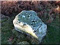
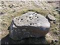
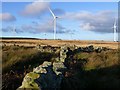
A boulder decorated with two cups and possible groove. Currently it is coverd with turf.
For more information see England's Rock Art entry for ERA-209 Wandylaw D, which includes a brief description, photographs, a sketch of the rock and its motifs, plus photogrammetry and media from the Beckensall Archhive.
The original Beckensall record can be found at Internet Archive: Beckensall 925 Wandylaw d.
This rock art panel is located on Open Access land.
You may be viewing yesterday's version of this page. To see the most up to date information please register for a free account.
Do not use the above information on other web sites or publications without permission of the contributor.
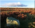
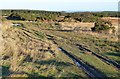
Nearby Images from Geograph Britain and Ireland:
©2014(licence)
©2014(licence)
©2014(licence)
©2006(licence)
©2014(licence)
The above images may not be of the site on this page, they are loaded from Geograph.
Please Submit an Image of this site or go out and take one for us!
Click here to see more info for this site
Nearby sites
Key: Red: member's photo, Blue: 3rd party photo, Yellow: other image, Green: no photo - please go there and take one, Grey: site destroyed
Download sites to:
KML (Google Earth)
GPX (GPS waypoints)
CSV (Garmin/Navman)
CSV (Excel)
To unlock full downloads you need to sign up as a Contributory Member. Otherwise downloads are limited to 50 sites.
Turn off the page maps and other distractions
Nearby sites listing. In the following links * = Image available
3m S 169° Wandylaw E* Rock Art (NU1379425109)
4m SSE 148° Wandylaw B Rock Art (NU1379525109)
9m ENE 63° Wandylaw G Rock Art (NU1380125116)
33m SSE 162° Wandylaw F* Rock Art (NU1380325081)
48m S 173° Wandylaw A* Rock Art (NU1379925064)
56m SSE 161° Wandylaw C* Rock Art (NU1381225059)
1.6km WNW 288° Lucker Moor 5* Rock Art (NU1226025593)
1.9km NW 316° Lucker Moor 4 Rock Art (NU1245126497)
2.1km NW 311° March Plantation* Cairn (NU12162651)
2.3km WNW 293° Rosebrough Moor Round Cairn 1* Round Cairn (NU117260)
2.3km WNW 290° Lucker Moor 6* Rock Art (NU1162025907)
2.4km WNW 302° Rosebrough Moor Round Cairn 2* Round Cairn (NU1178026360)
2.4km WNW 304° Lucker Moor 3* Rock Art (NU1176526445)
2.5km N 350° Isabella's Mount Camp Hillfort (NU13372757)
2.6km NW 310° Rayheugh Moor Cairn (c)* Cairn (NU11782679)
2.6km NW 305° Lucker Moor N2 Rock Art (NU1161926623)
2.6km NW 305° Lucker Moor 2* Rock Art (NU1161726627)
2.7km NW 310° Rayheugh Moor Cairn (b)* Cairn (NU11722681)
2.7km NW 306° Lucker Moor 1* Rock Art (NU1160026669)
2.7km NW 309° Rayheugh Moor Cairn (a)* Cairn (NU1165026840)
3.1km ENE 78° Ellingham b & c Rock Art (NU1686025750)
3.2km ENE 78° Ellingham a & d Rock Art (NU1691025790)
3.6km NW 306° Brownridge Burn 2 Rock Art (NU1084727235)
3.6km WNW 287° Chatton Sandyford 3 Rock Art (NU1028226145)
3.7km E 84° St Maurice's Well (Ellingham)* Holy Well or Sacred Spring (NU17452553)
View more nearby sites and additional images


 We would like to know more about this location. Please feel free to add a brief description and any relevant information in your own language.
 Wir möchten mehr über diese Stätte erfahren. Bitte zögern Sie nicht, eine kurze Beschreibung und relevante Informationen in Deutsch hinzuzufügen.
 Nous aimerions en savoir encore un peu sur les lieux. S'il vous plaît n'hesitez pas à ajouter une courte description et tous les renseignements pertinents dans votre propre langue.
 Quisieramos informarnos un poco más de las lugares. No dude en añadir una breve descripción y otros datos relevantes en su propio idioma.