<< Our Photo Pages >> Green Crag Slack 07 - Rock Art in England in Yorkshire (West)
Submitted by Anne T on Sunday, 04 February 2018 Page Views: 873
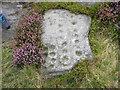
Rock ArtSite Name: Green Crag Slack 07 Alternative Name: ERA-2586; Boughey & Vickerman (324); SAM 25333Country: England County: Yorkshire (West) Type: Rock Art
Nearest Town: Ilkley
Map Ref: SE1326545945
Latitude: 53.909493N Longitude: 1.799563W
Condition:
| 5 | Perfect |
| 4 | Almost Perfect |
| 3 | Reasonable but with some damage |
| 2 | Ruined but still recognisable as an ancient site |
| 1 | Pretty much destroyed, possibly visible as crop marks |
| 0 | No data. |
| -1 | Completely destroyed |
| 5 | Superb |
| 4 | Good |
| 3 | Ordinary |
| 2 | Not Good |
| 1 | Awful |
| 0 | No data. |
| 5 | Can be driven to, probably with disabled access |
| 4 | Short walk on a footpath |
| 3 | Requiring a bit more of a walk |
| 2 | A long walk |
| 1 | In the middle of nowhere, a nightmare to find |
| 0 | No data. |
| 5 | co-ordinates taken by GPS or official recorded co-ordinates |
| 4 | co-ordinates scaled from a detailed map |
| 3 | co-ordinates scaled from a bad map |
| 2 | co-ordinates of the nearest village |
| 1 | co-ordinates of the nearest town |
| 0 | no data |
Internal Links:
External Links:
I have visited· I would like to visit
SolarMegalith visited on 14th Sep 2014 - their rating: Cond: 3 Amb: 4 Access: 3
")
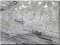
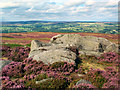
This rock art panel is one of nine rocks adjacent to the Idol Stone (see nearby sites below) and is recorded as having two wide, shallow cups. For more information see England's Rock Art entry for ERA-2586 Green Crag Slack 07, which includes a description, a plan of the stone and its motifs, plus photogrammetry.
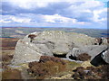
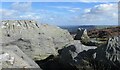
This rock art panel is located on Open Access land.
Note: Have you seen this rock art panel? Do you have any photographs or information to add?
You may be viewing yesterday's version of this page. To see the most up to date information please register for a free account.
")
Do not use the above information on other web sites or publications without permission of the contributor.
Nearby Images from Geograph Britain and Ireland:
©2015(licence)
©2016(licence)
©2016(licence)
©2022(licence)
©2005(licence)
The above images may not be of the site on this page, they are loaded from Geograph.
Please Submit an Image of this site or go out and take one for us!
Click here to see more info for this site
Nearby sites
Key: Red: member's photo, Blue: 3rd party photo, Yellow: other image, Green: no photo - please go there and take one, Grey: site destroyed
Download sites to:
KML (Google Earth)
GPX (GPS waypoints)
CSV (Garmin/Navman)
CSV (Excel)
To unlock full downloads you need to sign up as a Contributory Member. Otherwise downloads are limited to 50 sites.
Turn off the page maps and other distractions
Nearby sites listing. In the following links * = Image available
1m SSW 203° Green Crag Slack 06* Rock Art (SE1326545944)
2m SSW 198° Idol Stone* Rock Art (SE1326545943)
3m S 180° Green Crag Slack 05* Rock Art (SE1326545942)
29m SSE 149° Green Crag Slack* Rock Art (SE13284592)
31m SE 144° Green Crag Slack 08* Rock Art (SE1328345920)
37m WNW 288° Green Crag Slack 04* Rock Art (SE1323045956)
45m W 274° Green Crag Slack 03* Rock Art (SE1322045948)
48m W 260° Green Crag Slack 02* Rock Art (SE1321845937)
56m SSE 147° Green Crag Slack 09* Rock Art (SE1329645898)
57m SE 142° Green Crag Slack Enclosure Ancient Village or Settlement (SE13304590)
62m WSW 243° Green Crag Slack 01* Rock Art (SE1321045917)
87m WNW 298° Green Crag 12a* Rock Art (SE1318845986)
104m SSE 156° Green Crag Slack 10* Rock Art (SE1330845850)
124m WNW 291° Green Crag 14* Rock Art (SE1314945989)
170m WNW 287° Green Crag 13* Rock Art (SE1310245994)
179m W 273° Green Crag 11* Rock Art (SE1308645953)
200m WSW 241° Green Crag 12.* Rock Art (SE1309045847)
219m SW 229° Green Crag Top (Ilkley Moor) Cairn (SE131458)
226m ENE 60° Mini Skirtful of Stones (Ilkley Moor) Cairn (SE13464606)
234m NNE 25° Pancake Ridge 12 Rock Art (SE1336546157)
265m W 271° Green Crag 09* Rock Art (SE1299945949)
265m W 276° Green Crag Ancient Village or Settlement (SE13004597)
268m W 279° Green Crag 10* Rock Art (SE1299945986)
269m N 358° Pancake Ridge 07* Rock Art (SE1325446214)
269m NNE 21° Pancake Ridge 11.* Rock Art (SE1336146197)
View more nearby sites and additional images


 We would like to know more about this location. Please feel free to add a brief description and any relevant information in your own language.
 Wir möchten mehr über diese Stätte erfahren. Bitte zögern Sie nicht, eine kurze Beschreibung und relevante Informationen in Deutsch hinzuzufügen.
 Nous aimerions en savoir encore un peu sur les lieux. S'il vous plaît n'hesitez pas à ajouter une courte description et tous les renseignements pertinents dans votre propre langue.
 Quisieramos informarnos un poco más de las lugares. No dude en añadir una breve descripción y otros datos relevantes en su propio idioma.