<< Our Photo Pages >> Backstone Beck Enclosure - Ancient Village or Settlement in England in Yorkshire (West)
Submitted by DavidRaven on Tuesday, 23 November 2004 Page Views: 9262
Multi-periodSite Name: Backstone Beck EnclosureCountry: England County: Yorkshire (West) Type: Ancient Village or Settlement
Nearest Town: Ilkley
Map Ref: SE128461
Latitude: 53.910898N Longitude: 1.806635W
Condition:
| 5 | Perfect |
| 4 | Almost Perfect |
| 3 | Reasonable but with some damage |
| 2 | Ruined but still recognisable as an ancient site |
| 1 | Pretty much destroyed, possibly visible as crop marks |
| 0 | No data. |
| -1 | Completely destroyed |
| 5 | Superb |
| 4 | Good |
| 3 | Ordinary |
| 2 | Not Good |
| 1 | Awful |
| 0 | No data. |
| 5 | Can be driven to, probably with disabled access |
| 4 | Short walk on a footpath |
| 3 | Requiring a bit more of a walk |
| 2 | A long walk |
| 1 | In the middle of nowhere, a nightmare to find |
| 0 | No data. |
| 5 | co-ordinates taken by GPS or official recorded co-ordinates |
| 4 | co-ordinates scaled from a detailed map |
| 3 | co-ordinates scaled from a bad map |
| 2 | co-ordinates of the nearest village |
| 1 | co-ordinates of the nearest town |
| 0 | no data |
Internal Links:
External Links:
")
The publication 'Find the past on Ilkley Moor' (Bradford Metropolitan Council) says this of the site:-
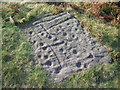
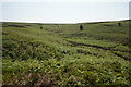
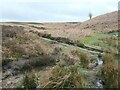
"Known as the Backstone Beck enclosure, this prehistoric site consists of extensive low rubble walling encompassing a small ridge that runs north towards the Backstones Beck ravine. It is now known that the walling belongs to the later Bronze Age (800-500 BC) but there is clear evidence that this area was a favourite camp-site for about two thousand years or more before that.
Many flints, some small fragments of pottery, part of a shale bangle and the rim of a jet cup have been unearthed during excavations on this site. Charcoal from four deposits on the site indicate sporadic use of the site from about 2,500 BC."
You may be viewing yesterday's version of this page. To see the most up to date information please register for a free account.
")
")
Do not use the above information on other web sites or publications without permission of the contributor.
Nearby Images from Geograph Britain and Ireland:

©2024(licence)
©2008(licence)
©2023(licence)

©2024(licence)
©2024(licence)
The above images may not be of the site on this page, they are loaded from Geograph.
Please Submit an Image of this site or go out and take one for us!
Click here to see more info for this site
Nearby sites
Key: Red: member's photo, Blue: 3rd party photo, Yellow: other image, Green: no photo - please go there and take one, Grey: site destroyed
Download sites to:
KML (Google Earth)
GPX (GPS waypoints)
CSV (Garmin/Navman)
CSV (Excel)
To unlock full downloads you need to sign up as a Contributory Member. Otherwise downloads are limited to 50 sites.
Turn off the page maps and other distractions
Nearby sites listing. In the following links * = Image available
59m NE 38° Backstone Beck 07* Rock Art (SE1283646147)
72m NNE 26° Backstone Beck 06* Rock Art (SE1283246165)
93m NNE 14° Backstone Beck 05.* Rock Art (SE1282246190)
128m SSE 166° Green Crag 01* Rock Art (SE1283145976)
157m NNE 12° Backstone Beck 05a Rock Art (SE1283246254)
161m NNW 338° Backstone Beck 04* Rock Art (SE1273846249)
181m SSE 159° Green Crag 02* Rock Art (SE1286645931)
188m NNW 335° Backstone Beck 03* Rock Art (SE1271946270)
197m W 279° Backstone Circle* Stone Circle (SE1260546130)
200m SE 139° Green Crag 05 Rock Art (SE1293245949)
201m SE 137° Green Crag 07* Rock Art (SE1293845954)
210m SE 129° Green Crag 08* Rock Art (SE1296445968)
220m NW 326° Backstone Beck 01* Rock Art (SE1267646282)
227m SE 145° Green Crag 04* Rock Art (SE1293045913)
229m ESE 120° Green Crag 10* Rock Art (SE1299945986)
232m SE 146° Green Crag 06* Rock Art (SE1293145908)
238m ESE 123° Green Crag Ancient Village or Settlement (SE13004597)
249m SE 127° Green Crag 09* Rock Art (SE1299945949)
252m WSW 253° Gill Head 01* Rock Art (SE1255846027)
262m SSE 149° Green Crag 03* Rock Art (SE1293745876)
289m NE 47° Pancake Ridge 04* Rock Art (SE1301246297)
291m NE 43° Pancake Ridge 03* Rock Art (SE1299846314)
304m NE 46° Green Crag Cairnfield Cairn (SE13024631)
308m NE 47° Haystack Rock* Rock Art (SE1302746309)
319m ESE 110° Green Crag 13* Rock Art (SE1310245994)
View more nearby sites and additional images


 We would like to know more about this location. Please feel free to add a brief description and any relevant information in your own language.
 Wir möchten mehr über diese Stätte erfahren. Bitte zögern Sie nicht, eine kurze Beschreibung und relevante Informationen in Deutsch hinzuzufügen.
 Nous aimerions en savoir encore un peu sur les lieux. S'il vous plaît n'hesitez pas à ajouter une courte description et tous les renseignements pertinents dans votre propre langue.
 Quisieramos informarnos un poco más de las lugares. No dude en añadir una breve descripción y otros datos relevantes en su propio idioma.