<< Our Photo Pages >> Backstone Beck 01 - Rock Art in England in Yorkshire (West)
Submitted by Anne T on Wednesday, 24 January 2018 Page Views: 959
Rock ArtSite Name: Backstone Beck 01 Alternative Name: ERA-2542; Boughey & Vickerman (280a); IAG280a; BB01Country: England County: Yorkshire (West) Type: Rock Art
Nearest Town: Ilkley
Map Ref: SE1267646282
Latitude: 53.912537N Longitude: 1.808515W
Condition:
| 5 | Perfect |
| 4 | Almost Perfect |
| 3 | Reasonable but with some damage |
| 2 | Ruined but still recognisable as an ancient site |
| 1 | Pretty much destroyed, possibly visible as crop marks |
| 0 | No data. |
| -1 | Completely destroyed |
| 5 | Superb |
| 4 | Good |
| 3 | Ordinary |
| 2 | Not Good |
| 1 | Awful |
| 0 | No data. |
| 5 | Can be driven to, probably with disabled access |
| 4 | Short walk on a footpath |
| 3 | Requiring a bit more of a walk |
| 2 | A long walk |
| 1 | In the middle of nowhere, a nightmare to find |
| 0 | No data. |
| 5 | co-ordinates taken by GPS or official recorded co-ordinates |
| 4 | co-ordinates scaled from a detailed map |
| 3 | co-ordinates scaled from a bad map |
| 2 | co-ordinates of the nearest village |
| 1 | co-ordinates of the nearest town |
| 0 | no data |
Be the first person to rate this site - see the 'Contribute!' box in the right hand menu.
Internal Links:
External Links:
")
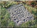
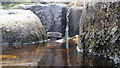
This rock art panel is recorded as having 1 cup with an almost complete ring around it and possible satellite cup, plus 2 other cups, one of which is very worn and may be natural. For more information see England's Rock Art entry for ERA-2542 Backstone Beck 01, which gives a description, and includes photographs, a plan of the stone and its motifs, plus photogrammetry.
This panel is also recorded in Boughey & Vickerman's "Prehistoric Rock Art of the West Riding Supplement (2018), pages 139 and 140. The Supplement includes a photograph of the rock and its motifs, plus a drawing of the panel. B&V adds: "(this panel is) on the gentle south slope of Cranshaw Thorn Hill, west of Backstone Beck, overlooking a broad, shallow grass-covered gully …. the rock is approximately 50-60cms in any one direction and carries a clear cup and an almost complete lipped ring with clear signs of pecking, with a possible shallow worn cup apparently in a 'sateliite' position."
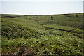
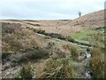
This rock is located on Open Access land.
You may be viewing yesterday's version of this page. To see the most up to date information please register for a free account.
Do not use the above information on other web sites or publications without permission of the contributor.
Nearby Images from Geograph Britain and Ireland:
©2023(licence)
©2008(licence)
©2024(licence)
©2009(licence)
©2010(licence)
The above images may not be of the site on this page, they are loaded from Geograph.
Please Submit an Image of this site or go out and take one for us!
Click here to see more info for this site
Nearby sites
Key: Red: member's photo, Blue: 3rd party photo, Yellow: other image, Green: no photo - please go there and take one, Grey: site destroyed
Download sites to:
KML (Google Earth)
GPX (GPS waypoints)
CSV (Garmin/Navman)
CSV (Excel)
To unlock full downloads you need to sign up as a Contributory Member. Otherwise downloads are limited to 50 sites.
Turn off the page maps and other distractions
Nearby sites listing. In the following links * = Image available
45m ESE 106° Backstone Beck 03* Rock Art (SE1271946270)
70m ESE 118° Backstone Beck 04* Rock Art (SE1273846249)
121m NW 309° Cranshaw Thorn Hill 08* Rock Art (SE1258246358)
158m E 100° Backstone Beck 05a Rock Art (SE1283246254)
168m SSW 205° Backstone Circle* Stone Circle (SE1260546130)
172m ESE 122° Backstone Beck 05.* Rock Art (SE1282246190)
195m SE 127° Backstone Beck 06* Rock Art (SE1283246165)
209m SE 130° Backstone Beck 07* Rock Art (SE1283646147)
220m SE 146° Backstone Beck Enclosure* Ancient Village or Settlement (SE128461)
277m ENE 60° Pancake Ridge 01a* Rock Art (SE1291746419)
281m SSW 205° Gill Head 01* Rock Art (SE1255846027)
306m ENE 68° The Planets* Rock Art (SE1296146396)
312m N 6° Backstone Beck 02* Rock Art (SE1270946592)
323m E 84° Pancake Ridge 03* Rock Art (SE1299846314)
331m ENE 72° Pancake Ridge 02* Rock Art (SE1299146385)
332m WNW 282° Cranshaw Thorn Hill 07 Rock Art (SE1235046350)
335m E 88° Pancake Ridge 04* Rock Art (SE1301246297)
341m W 261° Cranshaw Thorn Hill 06* Rock Art (SE1233846230)
343m SSE 153° Green Crag 01* Rock Art (SE1283145976)
344m E 85° Green Crag Cairnfield Cairn (SE13024631)
348m W 275° Cranshaw Thorn Hill 05* Rock Art (SE1232846312)
351m E 86° Haystack Rock* Rock Art (SE1302746309)
399m SSE 152° Green Crag 02* Rock Art (SE1286645931)
410m W 280° Cranshaw Thorn Hill Rock Art (SE12274635)
419m SE 142° Green Crag 07* Rock Art (SE1293845954)
View more nearby sites and additional images


 We would like to know more about this location. Please feel free to add a brief description and any relevant information in your own language.
 Wir möchten mehr über diese Stätte erfahren. Bitte zögern Sie nicht, eine kurze Beschreibung und relevante Informationen in Deutsch hinzuzufügen.
 Nous aimerions en savoir encore un peu sur les lieux. S'il vous plaît n'hesitez pas à ajouter une courte description et tous les renseignements pertinents dans votre propre langue.
 Quisieramos informarnos un poco más de las lugares. No dude en añadir una breve descripción y otros datos relevantes en su propio idioma.