<< Our Photo Pages >> Backstone Circle - Stone Circle in England in Yorkshire (West)
Submitted by DavidRaven on Friday, 15 August 2003 Page Views: 12959
Neolithic and Bronze AgeSite Name: Backstone CircleCountry: England County: Yorkshire (West) Type: Stone Circle
Map Ref: SE1260546130 Landranger Map Number: 104
Latitude: 53.911172N Longitude: 1.809602W
Condition:
| 5 | Perfect |
| 4 | Almost Perfect |
| 3 | Reasonable but with some damage |
| 2 | Ruined but still recognisable as an ancient site |
| 1 | Pretty much destroyed, possibly visible as crop marks |
| 0 | No data. |
| -1 | Completely destroyed |
| 5 | Superb |
| 4 | Good |
| 3 | Ordinary |
| 2 | Not Good |
| 1 | Awful |
| 0 | No data. |
| 5 | Can be driven to, probably with disabled access |
| 4 | Short walk on a footpath |
| 3 | Requiring a bit more of a walk |
| 2 | A long walk |
| 1 | In the middle of nowhere, a nightmare to find |
| 0 | No data. |
| 5 | co-ordinates taken by GPS or official recorded co-ordinates |
| 4 | co-ordinates scaled from a detailed map |
| 3 | co-ordinates scaled from a bad map |
| 2 | co-ordinates of the nearest village |
| 1 | co-ordinates of the nearest town |
| 0 | no data |
Internal Links:
External Links:
I have visited· I would like to visit
paganjones7 visited on 13th Jun 2015 - their rating: Cond: 3 Access: 3 A favourite site of mine.Getting a bit overgrown with grass over last few years.If you view it from across the beck,you will see it sits in a hollow and in very wet weather a spring still runs occasionally leading me to think it is built deliberately near a water source.Very powerful .entity sightings happen here as well .
Paulbm79 TimPrevett have visited here
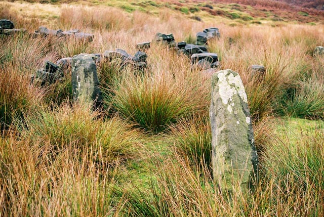
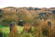
This charming, tumbledown, overgrown circle, camaflouged by newer dry-stone walls takes some finding, but it's certainly worth the effort! It's perched on the flanks of the Backstone Beck valley. I must've walked near it dozens of times over the years and never noticed it. Maybe it's because it's hidden amongst more recent constructions, or maybe it's only noticed if you're actually intent on finding it!
The stones nestle into the moorland vegetation, partially obscured by great tussocks of sedge. To me, the attendant man-made remains don't seem to detract from the peaceful sanctity of the place. The circle was 'forgotten' until quite recently. At first 'the jury was out' as to it's authenticity. Collyer and Turner (1885) mention a 'rude circle of stones' that you had to look twice at to see, situated somewhere beyond the White Wells. This fits the bill! Today though, it seems the archaeologists and megalith-hunters have vouched for it's worth and included it in some of the current guides to the moors. If this is a tenuously verified site then the alignments which occur here are a miraculous coincidence! Folks more attuned to these things than I have observed lines of reddish light, which dowsing has corroborated.
The Northern Antiquarian alsohave an page for this stone circle - see their entry for Backstone Circle, Ilkley Moor, West Yorkshire which contains directions for finding the site, photographs, a brief archaeology & history and a intriguing 'Fortean History' section.
You may be viewing yesterday's version of this page. To see the most up to date information please register for a free account.


Do not use the above information on other web sites or publications without permission of the contributor.
Click here to see more info for this site
Nearby sites
Key: Red: member's photo, Blue: 3rd party photo, Yellow: other image, Green: no photo - please go there and take one, Grey: site destroyed
Download sites to:
KML (Google Earth)
GPX (GPS waypoints)
CSV (Garmin/Navman)
CSV (Excel)
To unlock full downloads you need to sign up as a Contributory Member. Otherwise downloads are limited to 50 sites.
Turn off the page maps and other distractions
Nearby sites listing. In the following links * = Image available
113m SSW 205° Gill Head 01* Rock Art (SE1255846027)
168m NNE 25° Backstone Beck 01* Rock Art (SE1267646282)
178m NE 48° Backstone Beck 04* Rock Art (SE1273846249)
180m NE 39° Backstone Beck 03* Rock Art (SE1271946270)
197m E 99° Backstone Beck Enclosure* Ancient Village or Settlement (SE128461)
225m ENE 75° Backstone Beck 05.* Rock Art (SE1282246190)
229m N 354° Cranshaw Thorn Hill 08* Rock Art (SE1258246358)
229m E 81° Backstone Beck 06* Rock Art (SE1283246165)
231m E 86° Backstone Beck 07* Rock Art (SE1283646147)
258m ENE 61° Backstone Beck 05a Rock Art (SE1283246254)
273m SE 124° Green Crag 01* Rock Art (SE1283145976)
284m WNW 291° Cranshaw Thorn Hill 06* Rock Art (SE1233846230)
328m SE 128° Green Crag 02* Rock Art (SE1286645931)
331m WNW 304° Cranshaw Thorn Hill 05* Rock Art (SE1232846312)
336m NW 311° Cranshaw Thorn Hill 07 Rock Art (SE1235046350)
373m ESE 119° Green Crag 05 Rock Art (SE1293245949)
376m ESE 118° Green Crag 07* Rock Art (SE1293845954)
390m SE 124° Green Crag 04* Rock Art (SE1293045913)
393m ESE 114° Green Crag 08* Rock Art (SE1296445968)
394m SE 124° Green Crag 06* Rock Art (SE1293145908)
400m WNW 304° Cranshaw Thorn Hill Rock Art (SE12274635)
415m WNW 299° Cranshaw Thorn Hill 02 Rock Art (SE1224046330)
417m SE 128° Green Crag 03* Rock Art (SE1293745876)
418m ESE 110° Green Crag 10* Rock Art (SE1299945986)
419m NW 304° Cranshaw Thorn Hill 04* Rock Art (SE1225646364)
View more nearby sites and additional images


 We would like to know more about this location. Please feel free to add a brief description and any relevant information in your own language.
 Wir möchten mehr über diese Stätte erfahren. Bitte zögern Sie nicht, eine kurze Beschreibung und relevante Informationen in Deutsch hinzuzufügen.
 Nous aimerions en savoir encore un peu sur les lieux. S'il vous plaît n'hesitez pas à ajouter une courte description et tous les renseignements pertinents dans votre propre langue.
 Quisieramos informarnos un poco más de las lugares. No dude en añadir una breve descripción y otros datos relevantes en su propio idioma.