<< Text Pages >> Hunterheugh 12 - Rock Art in England in Northumberland
Submitted by Anne T on Saturday, 24 March 2018 Page Views: 803
Rock ArtSite Name: Hunterheugh 12 Alternative Name: ERA-493Country: England County: Northumberland Type: Rock Art
Nearest Town: Alnwick Nearest Village: Eglingham / East Bolton
Map Ref: NU1167116754
Latitude: 55.444522N Longitude: 1.817064W
Condition:
| 5 | Perfect |
| 4 | Almost Perfect |
| 3 | Reasonable but with some damage |
| 2 | Ruined but still recognisable as an ancient site |
| 1 | Pretty much destroyed, possibly visible as crop marks |
| 0 | No data. |
| -1 | Completely destroyed |
| 5 | Superb |
| 4 | Good |
| 3 | Ordinary |
| 2 | Not Good |
| 1 | Awful |
| 0 | No data. |
| 5 | Can be driven to, probably with disabled access |
| 4 | Short walk on a footpath |
| 3 | Requiring a bit more of a walk |
| 2 | A long walk |
| 1 | In the middle of nowhere, a nightmare to find |
| 0 | No data. |
| 5 | co-ordinates taken by GPS or official recorded co-ordinates |
| 4 | co-ordinates scaled from a detailed map |
| 3 | co-ordinates scaled from a bad map |
| 2 | co-ordinates of the nearest village |
| 1 | co-ordinates of the nearest town |
| 0 | no data |
Be the first person to rate this site - see the 'Contribute!' box in the right hand menu.
Internal Links:
External Links:
Rock Art in Northumberland
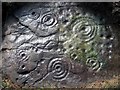
This rock art panel was discovered by NADRAP and is recorded as being on a large block which has either been quarried or slipped off naturally and now lies on top of other boulders. It has a possible cup and ring on its western end of the outcrop; a single cup on the massive fallen slab and three cups on a smaller fallen rock just below the main slab. All motifs are heavily eroded.
For more information see England's Rock Art entry for ERA-493 Hunterheugh 12, which includes photographs, a sketch of the rock and its motifs plus photogrammetry.
This rock art panel is located on Open Access land.
Note: Have you seen this rock art panel? Do you have any photographs or information to add?
You may be viewing yesterday's version of this page. To see the most up to date information please register for a free account.
Do not use the above information on other web sites or publications without permission of the contributor.
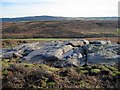
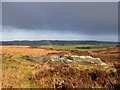
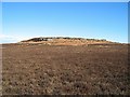
Nearby Images from Geograph Britain and Ireland:

©2009(licence)
©2020(licence)
©2009(licence)
©2009(licence)
©2008(licence)
The above images may not be of the site on this page, they are loaded from Geograph.
Please Submit an Image of this site or go out and take one for us!
Click here to see more info for this site
Nearby sites
Key: Red: member's photo, Blue: 3rd party photo, Yellow: other image, Green: no photo - please go there and take one, Grey: site destroyed
Download sites to:
KML (Google Earth)
GPX (GPS waypoints)
CSV (Garmin/Navman)
CSV (Excel)
To unlock full downloads you need to sign up as a Contributory Member. Otherwise downloads are limited to 50 sites.
Turn off the page maps and other distractions
Nearby sites listing. In the following links * = Image available
58m NNE 12° Hunterheugh 3* Rock Art (NU1168316811)
62m SW 222° Hunterheugh 8h Rock Art (NU1163016708)
66m SW 227° Hunterheugh 8b Rock Art (NU1162316709)
83m SW 223° Hunterheugh 8c Rock Art (NU1161516693)
83m ENE 72° Hunterheugh Excavation Portable Panels Rock Art (NU1175016780)
85m ENE 67° Hunterheugh 1.* Rock Art (NU1175016787)
85m SW 224° Hunterheugh 8g Rock Art (NU1161216692)
89m NNE 14° Hunterheugh 2* Rock Art (NU1169216841)
90m SW 224° Hunterheugh 8d Rock Art (NU1160916689)
90m SW 225° Hunterheugh 8e Rock Art (NU1160716690)
93m SW 225° Hunterheugh 8f Rock Art (NU1160516688)
95m SW 224° Hunterheugh 8a Rock Art (NU1160516686)
134m NNE 17° Hunterheugh 7 Rock Art (NU1171116882)
155m NW 315° Hunterheugh 13* Rock Art (NU1156116863)
157m NW 315° Hunterheugh 14* Rock Art (NU1156016866)
158m WSW 247° Hunterheugh 9 Rock Art (NU1152616691)
206m WSW 247° Hunterheugh 10 Rock Art (NU1148116674)
225m ENE 78° Hunterheugh 5* Rock Art (NU1189216800)
228m ENE 78° Hunterheugh 4* Rock Art (NU1189516801)
231m WNW 301° Hunterheugh 11 Rock Art (NU1147216873)
293m WNW 301° Hunterheugh 6* Rock Art (NU1141816904)
316m WNW 298° Hunterheugh 6b Rock Art (NU1139216904)
1.4km SSE 148° Midstead 5 Rock Art (NU1240115583)
1.4km WSW 255° Titlington Mount N02* Rock Art (NU1029016368)
1.5km SSE 150° Midstead 1* Rock Art (NU1242115460)
View more nearby sites and additional images


 We would like to know more about this location. Please feel free to add a brief description and any relevant information in your own language.
 Wir möchten mehr über diese Stätte erfahren. Bitte zögern Sie nicht, eine kurze Beschreibung und relevante Informationen in Deutsch hinzuzufügen.
 Nous aimerions en savoir encore un peu sur les lieux. S'il vous plaît n'hesitez pas à ajouter une courte description et tous les renseignements pertinents dans votre propre langue.
 Quisieramos informarnos un poco más de las lugares. No dude en añadir una breve descripción y otros datos relevantes en su propio idioma.