<< Our Photo Pages >> Graining's Head 02 - Rock Art in England in Yorkshire (West)
Submitted by Anne T on Friday, 02 February 2018 Page Views: 1047
Rock ArtSite Name: Graining's Head 02 Alternative Name: ERA-2335; Boughey & Vickerman (249); SAM 25368; PRN178Country: England County: Yorkshire (West) Type: Rock Art
Nearest Town: Ilkley
Map Ref: SE1100746451
Latitude: 53.914093N Longitude: 1.833917W
Condition:
| 5 | Perfect |
| 4 | Almost Perfect |
| 3 | Reasonable but with some damage |
| 2 | Ruined but still recognisable as an ancient site |
| 1 | Pretty much destroyed, possibly visible as crop marks |
| 0 | No data. |
| -1 | Completely destroyed |
| 5 | Superb |
| 4 | Good |
| 3 | Ordinary |
| 2 | Not Good |
| 1 | Awful |
| 0 | No data. |
| 5 | Can be driven to, probably with disabled access |
| 4 | Short walk on a footpath |
| 3 | Requiring a bit more of a walk |
| 2 | A long walk |
| 1 | In the middle of nowhere, a nightmare to find |
| 0 | No data. |
| 5 | co-ordinates taken by GPS or official recorded co-ordinates |
| 4 | co-ordinates scaled from a detailed map |
| 3 | co-ordinates scaled from a bad map |
| 2 | co-ordinates of the nearest village |
| 1 | co-ordinates of the nearest town |
| 0 | no data |
Be the first person to rate this site - see the 'Contribute!' box in the right hand menu.
Internal Links:
External Links:
")
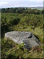
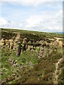
This rock art panel is recorded as have three shallow, weathered cups, a possible further seven cups along a ridge on the south side of the panel, and two fissures running along its top surface. The seven cups are very weathered an it was not possible to determine if they were carved or natural. For more information see England's Rock Art entry for ERA-2335 Graining's Head 02, which includes a description, photographs, a plan of the rock and its motifs, plus photogrammetry.
This rock art panel is located on Open Access land.
Note: Have you seen this rock art panel? Do you have any photographs or information to add?
You may be viewing yesterday's version of this page. To see the most up to date information please register for a free account.
Do not use the above information on other web sites or publications without permission of the contributor.
Nearby Images from Geograph Britain and Ireland:

©2020(licence)
©2012(licence)
©2008(licence)
©2008(licence)
©2013(licence)
The above images may not be of the site on this page, they are loaded from Geograph.
Please Submit an Image of this site or go out and take one for us!
Click here to see more info for this site
Nearby sites
Key: Red: member's photo, Blue: 3rd party photo, Yellow: other image, Green: no photo - please go there and take one, Grey: site destroyed
Download sites to:
KML (Google Earth)
GPX (GPS waypoints)
CSV (Garmin/Navman)
CSV (Excel)
To unlock full downloads you need to sign up as a Contributory Member. Otherwise downloads are limited to 50 sites.
Turn off the page maps and other distractions
Nearby sites listing. In the following links * = Image available
90m E 84° Barmishaw 01* Rock Art (SE1109746460)
187m E 100° Barmishaw Stone* Rock Art (SE1119246419)
243m W 280° Graining's Head 01* Rock Art (SE1076746492)
338m SSE 163° Green Gates 01.* Rock Art (SE1110546127)
349m SSE 156° Green Gates 02* Rock Art (SE1114946132)
406m S 171° Badger Stone* Rock Art (SE1107446050)
413m WNW 289° Weary Hill Stone* Rock Art (SE1061546585)
413m WNW 289° Weary Hill 03* Rock Art (SE1061546585)
436m N 357° Westwood Drive 01* Rock Art (SE1098346887)
440m WSW 243° Weary Hill 02* Rock Art (SE1061446251)
449m WSW 255° Weary Hill 01* Rock Art (SE1057246336)
468m SE 137° Green Gates 03* Rock Art (SE1133046111)
476m N 359° Westwood Drive 02* Rock Art (SE1100146927)
506m WNW 289° Silver Well 05* Rock Art (SE1052746616)
544m WNW 289° Silver Well 04* Rock Art (SE1048946623)
562m WNW 289° Silver Well 02* Rock Art (SE1047446635)
566m WNW 294° Silver Well 03* Rock Art (SE1048946682)
580m SE 135° Green Gates 04* Rock Art (SE1141746040)
592m ENE 76° Willy Hall's Wood Stone* Rock Art (SE1158446592)
614m W 267° Coarse Stone Edge 02a* Rock Art (SE1039246419)
616m W 265° Coarse Stone Edge 03* Rock Art (SE1039246396)
618m W 264° Coarse Stone Edge 04* Rock Art (SE1039046390)
618m W 264° Neb Stone* Rock Art (SE10394639)
634m SE 129° Green Gates 06* Rock Art (SE1149946049)
636m SE 130° Green Gates 05* Rock Art (SE1149846045)
View more nearby sites and additional images


 We would like to know more about this location. Please feel free to add a brief description and any relevant information in your own language.
 Wir möchten mehr über diese Stätte erfahren. Bitte zögern Sie nicht, eine kurze Beschreibung und relevante Informationen in Deutsch hinzuzufügen.
 Nous aimerions en savoir encore un peu sur les lieux. S'il vous plaît n'hesitez pas à ajouter une courte description et tous les renseignements pertinents dans votre propre langue.
 Quisieramos informarnos un poco más de las lugares. No dude en añadir una breve descripción y otros datos relevantes en su propio idioma.