 with our Megalithic Portal iPhone app")

<< Text Pages >> Kettley Crags N01 - Rock Art in England in Northumberland
Submitted by Anne T on Sunday, 18 March 2018 Page Views: 854
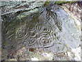
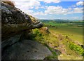
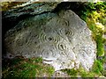
Rock ArtSite Name: Kettley Crags N01 Alternative Name: ERA-381; Ketley Crags N01Country: England County: Northumberland Type: Rock Art
Nearest Town: Wooler Nearest Village: Chatton
Map Ref: NU0747729842
Latitude: 55.562204N Longitude: 1.883013W
Condition:
| 5 | Perfect |
| 4 | Almost Perfect |
| 3 | Reasonable but with some damage |
| 2 | Ruined but still recognisable as an ancient site |
| 1 | Pretty much destroyed, possibly visible as crop marks |
| 0 | No data. |
| -1 | Completely destroyed |
| 5 | Superb |
| 4 | Good |
| 3 | Ordinary |
| 2 | Not Good |
| 1 | Awful |
| 0 | No data. |
| 5 | Can be driven to, probably with disabled access |
| 4 | Short walk on a footpath |
| 3 | Requiring a bit more of a walk |
| 2 | A long walk |
| 1 | In the middle of nowhere, a nightmare to find |
| 0 | No data. |
| 5 | co-ordinates taken by GPS or official recorded co-ordinates |
| 4 | co-ordinates scaled from a detailed map |
| 3 | co-ordinates scaled from a bad map |
| 2 | co-ordinates of the nearest village |
| 1 | co-ordinates of the nearest town |
| 0 | no data |
Be the first person to rate this site - see the 'Contribute!' box in the right hand menu.
Internal Links:
External Links:
Rock Art in Northumberland
This rock art panel is recorded as England's Rock Art entry for ERA-381 Kettley Crags N01, which includes photographs, sketches of the rock and its motifs, plus photogrammetry.
It is not recorded if this rock art panel is located on Open Access or private land, although the nearby rock shelter (see 'nearby sites' below) is on private land.
Note: Have you seen this rock art panel? Do you have any photographs or information to add?
You may be viewing yesterday's version of this page. To see the most up to date information please register for a free account.
Do not use the above information on other web sites or publications without permission of the contributor.
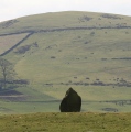
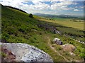
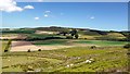
Nearby Images from Geograph Britain and Ireland:
©2009(licence)
©2010(licence)
©2009(licence)
©2009(licence)
©2009(licence)
The above images may not be of the site on this page, they are loaded from Geograph.
Please Submit an Image of this site or go out and take one for us!
Click here to see more info for this site
Nearby sites
Key: Red: member's photo, Blue: 3rd party photo, Yellow: other image, Green: no photo - please go there and take one, Grey: site destroyed
Download sites to:
KML (Google Earth)
GPX (GPS waypoints)
CSV (Garmin/Navman)
CSV (Excel)
To unlock full downloads you need to sign up as a Contributory Member. Otherwise downloads are limited to 50 sites.
Turn off the page maps and other distractions
Nearby sites listing. In the following links * = Image available
41m SSW 202° Ketley Crag Rock Shelter 1* Rock Art (NU0746229804)
273m S 191° Chatton 6c Rock Art (NU0742629574)
274m S 190° Chatton 6b Rock Art (NU0743129572)
278m S 190° Chatton 6a* Rock Art (NU0742829568)
300m S 183° Chatton 6d Rock Art (NU0746429542)
350m SSW 193° Chatton 6e Rock Art (NU0740029500)
442m SSW 193° Chatton 8a & 8b Rock Art (NU0738029410)
448m SSW 209° Chatton 14 Rock Art (NU0725829451)
513m S 186° Chatton 7 Rock Art (NU0742729331)
515m SSE 149° Chatton 9a* Rock Art (NU0774229399)
516m SSW 211° Chatton Camp* Hillfort (NU07212940)
522m SSW 209° Chatton 4* Rock Art (NU0722329385)
567m SSW 192° Chatton 12* Rock Art (NU0735829287)
598m SSE 148° Chatton 9b* Rock Art (NU0779529334)
604m SSE 166° Chatton 5* Rock Art (NU0762929257)
606m S 188° Chatton 13* Rock Art (NU0739129242)
699m S 183° Chatton 15b Rock Art (NU0743829143)
702m S 183° Chatton 15a Rock Art (NU0744729140)
719m S 175° Chatton 11 Rock Art (NU0753529125)
723m S 176° Chatton 10 Rock Art (NU0753029120)
739m SSE 151° Chatton 16 Rock Art (NU0783429194)
756m S 174° Chatton 2* Rock Art (NU0755329089)
763m S 173° Chatton 3* Rock Art (NU0756629084)
770m S 174° Chatton 1c Rock Art (NU0756129076)
780m S 174° Chatton 1b Rock Art (NU0755529065)
View more nearby sites and additional images


 We would like to know more about this location. Please feel free to add a brief description and any relevant information in your own language.
 Wir möchten mehr über diese Stätte erfahren. Bitte zögern Sie nicht, eine kurze Beschreibung und relevante Informationen in Deutsch hinzuzufügen.
 Nous aimerions en savoir encore un peu sur les lieux. S'il vous plaît n'hesitez pas à ajouter une courte description et tous les renseignements pertinents dans votre propre langue.
 Quisieramos informarnos un poco más de las lugares. No dude en añadir una breve descripción y otros datos relevantes en su propio idioma.