<< Our Photo Pages >> Stanway Bowl Barrows - Round Barrow(s) in England in Gloucestershire
Submitted by 4clydesdale7 on Sunday, 17 June 2012 Page Views: 3671
Neolithic and Bronze AgeSite Name: Stanway Bowl Barrows Alternative Name: Stanway 1 & 2Country: England County: Gloucestershire Type: Round Barrow(s)
Nearest Town: Winchcombe Nearest Village: Stanway
Map Ref: SP07413044
Latitude: 51.972382N Longitude: 1.893541W
Condition:
| 5 | Perfect |
| 4 | Almost Perfect |
| 3 | Reasonable but with some damage |
| 2 | Ruined but still recognisable as an ancient site |
| 1 | Pretty much destroyed, possibly visible as crop marks |
| 0 | No data. |
| -1 | Completely destroyed |
| 5 | Superb |
| 4 | Good |
| 3 | Ordinary |
| 2 | Not Good |
| 1 | Awful |
| 0 | No data. |
| 5 | Can be driven to, probably with disabled access |
| 4 | Short walk on a footpath |
| 3 | Requiring a bit more of a walk |
| 2 | A long walk |
| 1 | In the middle of nowhere, a nightmare to find |
| 0 | No data. |
| 5 | co-ordinates taken by GPS or official recorded co-ordinates |
| 4 | co-ordinates scaled from a detailed map |
| 3 | co-ordinates scaled from a bad map |
| 2 | co-ordinates of the nearest village |
| 1 | co-ordinates of the nearest town |
| 0 | no data |
Internal Links:
External Links:
I have visited· I would like to visit
4clydesdale7 visited on 16th Jun 2012 - their rating: Cond: 2 Amb: 3 Access: 4 Easy to find with some interesting other sites locally - Willersey Hillfort and Long Barrow; Stanway Tithe Barn; Hailes Abbey; both 'alleged' sites of Stumps Cross; Shenberrow Hillfort; Beckbury Camp; Odo and Dodo - all 'within a stone's throw'
")
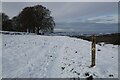
Close to Stumps Cross, there are beautiful views to the NW. The Barrows have suffered badly over time from the plough, the field within which they lie is known as 'Bone Yard Ground'. The northerly barrow is 20m diameter and about 0.6m high, the southerly is a little smaller 18m diameter and 0.5m high -
Just 200m to the SE lies the crossroads (known as Stumps Cross) of a Saltway and an ancient trackway between Tewkesbury and Stow-on-the-Wold - on the roadside verge by the footpath leading past the barrows is the base of an Ancient Wayside Cross
You may be viewing yesterday's version of this page. To see the most up to date information please register for a free account.
")
")
Do not use the above information on other web sites or publications without permission of the contributor.
Nearby Images from Geograph Britain and Ireland:

©2009(licence)

©2013(licence)

©2009(licence)

©2009(licence)
©2022(licence)
The above images may not be of the site on this page, they are loaded from Geograph.
Please Submit an Image of this site or go out and take one for us!
Click here to see more info for this site
Nearby sites
Key: Red: member's photo, Blue: 3rd party photo, Yellow: other image, Green: no photo - please go there and take one, Grey: site destroyed
Download sites to:
KML (Google Earth)
GPX (GPS waypoints)
CSV (Garmin/Navman)
CSV (Excel)
To unlock full downloads you need to sign up as a Contributory Member. Otherwise downloads are limited to 50 sites.
Turn off the page maps and other distractions
Nearby sites listing. In the following links * = Image available
436m SW 217° Campden Lane gatepost* Marker Stone (SP07153009)
1.2km WSW 241° Beckbury Camp* Hillfort (SP06392988)
1.8km WSW 259° Hailes Wood Earthworks Misc. Earthwork (SP05663009)
1.8km E 92° Cutsdean Henge (SP09263038)
2.3km SSW 211° Farmcote gatepost* Standing Stone (Menhir) (SP0624828468)
3.1km NNE 12° Shenberrow Hillfort* Hillfort (SP08043344)
3.4km NNE 31° Snowshill* Round Barrow(s) (SP09153335)
3.9km S 185° Guiting Wood Bowl Barrow* Round Barrow(s) (SP0710826545)
4.0km SW 229° St. Kenelm's Well* Holy Well or Sacred Spring (SP0435827795)
5.2km WNW 285° The Warren Hillfort (SP024318)
6.1km S 170° Greenfield Hill Barn Round Barrow* Round Barrow(s) (SP0844224465)
6.2km ESE 105° Oak Piece Chambered Tomb (SP134289)
6.3km SSE 160° Guiting Power Round Barrow 3* Timber Circle (SP096245)
6.4km S 180° Roel Farm Bowl Barrow* Round Barrow(s) (SP0740324085)
6.7km SSW 204° Roel Camp* Hillfort (SP04682434)
7.1km SE 126° Cow Common Barrow Cemetery* Barrow Cemetery (SP132263)
7.2km ESE 122° Cow Common Long Barrow* Chambered Cairn (SP135266)
7.2km SE 131° Huntsmans Quarry Timber Circle (SP129257)
7.3km SW 227° Belas Knap* Long Barrow (SP02092545)
7.5km WNW 282° Alderton Cursus Cursus (SP00023199)
7.6km NE 35° The Harford Member* Natural Stone / Erratic / Other Natural Feature (SP118366)
7.8km ESE 121° Swell Wold round barrow* Round Barrow(s) (SP14132648)
8.0km ESE 106° Cross Well (Condicote)* Holy Well or Sacred Spring (SP15122827)
8.2km ESE 105° Condicote henge* Henge (SP15392837)
8.3km SE 124° Eyeford Chambered Cairn (SP143258)
View more nearby sites and additional images


 We would like to know more about this location. Please feel free to add a brief description and any relevant information in your own language.
 Wir möchten mehr über diese Stätte erfahren. Bitte zögern Sie nicht, eine kurze Beschreibung und relevante Informationen in Deutsch hinzuzufügen.
 Nous aimerions en savoir encore un peu sur les lieux. S'il vous plaît n'hesitez pas à ajouter une courte description et tous les renseignements pertinents dans votre propre langue.
 Quisieramos informarnos un poco más de las lugares. No dude en añadir una breve descripción y otros datos relevantes en su propio idioma.