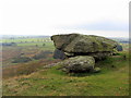
<< Our Photo Pages >> Shaftoe Crag Camp - Hillfort in England in Northumberland
Submitted by SolarMegalith on Monday, 07 November 2016 Page Views: 3990
Iron Age and Later PrehistorySite Name: Shaftoe Crag CampCountry: England County: Northumberland Type: Hillfort
Map Ref: NZ05158170
Latitude: 55.129647N Longitude: 1.920772W
Condition:
| 5 | Perfect |
| 4 | Almost Perfect |
| 3 | Reasonable but with some damage |
| 2 | Ruined but still recognisable as an ancient site |
| 1 | Pretty much destroyed, possibly visible as crop marks |
| 0 | No data. |
| -1 | Completely destroyed |
| 5 | Superb |
| 4 | Good |
| 3 | Ordinary |
| 2 | Not Good |
| 1 | Awful |
| 0 | No data. |
| 5 | Can be driven to, probably with disabled access |
| 4 | Short walk on a footpath |
| 3 | Requiring a bit more of a walk |
| 2 | A long walk |
| 1 | In the middle of nowhere, a nightmare to find |
| 0 | No data. |
| 5 | co-ordinates taken by GPS or official recorded co-ordinates |
| 4 | co-ordinates scaled from a detailed map |
| 3 | co-ordinates scaled from a bad map |
| 2 | co-ordinates of the nearest village |
| 1 | co-ordinates of the nearest town |
| 0 | no data |
Internal Links:
External Links:
I have visited· I would like to visit
SolarMegalith visited on 27th Sep 2016 - their rating: Cond: 4 Amb: 5 Access: 4
")
Pastscape entry.
You may be viewing yesterday's version of this page. To see the most up to date information please register for a free account.
")
")
")
")
Do not use the above information on other web sites or publications without permission of the contributor.
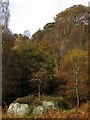
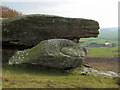
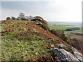
Nearby Images from Geograph Britain and Ireland:
©2014(licence)
©2014(licence)
©2014(licence)
©2014(licence)
©2014(licence)
The above images may not be of the site on this page, they are loaded from Geograph.
Please Submit an Image of this site or go out and take one for us!
Click here to see more info for this site
Nearby sites
Key: Red: member's photo, Blue: 3rd party photo, Yellow: other image, Green: no photo - please go there and take one, Grey: site destroyed
Download sites to:
KML (Google Earth)
GPX (GPS waypoints)
CSV (Garmin/Navman)
CSV (Excel)
To unlock full downloads you need to sign up as a Contributory Member. Otherwise downloads are limited to 50 sites.
Turn off the page maps and other distractions
Nearby sites listing. In the following links * = Image available
440m S 187° Ferney Chesters N01 Rock Art (NZ0509981263)
441m S 187° Ferney Chesters N02 Ring Cairn (NZ0510081261)
443m WSW 246° West Shaftoe Farm N02 Rock Art (NZ0474381522)
452m S 185° Ferney Chesters N04 Rock Art (NZ0510981250)
462m WSW 243° West Shaftoe Farm N01 Rock Art (NZ0473681493)
465m SSW 195° Ferney Chesters N06 Rock Art (NZ0502681251)
467m WSW 242° West Shaftoe Farm 2b Rock Art (NZ0473581483)
468m WSW 242° West Shaftoe Farm 2a Rock Art (NZ0473481482)
472m WSW 244° West Shaftoe Farm 1b Rock Art (NZ0472681489)
483m SSW 195° Ferney Chesters N03 Rock Art (NZ0502581233)
485m WSW 244° West Shaftoe Farm 1a* Rock Art (NZ0471581483)
489m S 173° Ferney Chesters N05 Rock Art (NZ0521281215)
678m NNE 12° Shaftoe (Shaftoe Crags) Rock Art (NZ0528782365)
679m NNE 17° Salters Nick Settlement* Ancient Village or Settlement (NZ05358235)
688m NE 38° Salters Nick Rock Shelter Rock Art (NZ0557582243)
824m NNE 15° Shaftoe Jubilee Stone A Rock Art (NZ0536382497)
843m NNE 15° Shaftoe Jubilee Stone B* Rock Art (NZ0537082515)
1.1km ESE 117° Devil's Causeway (Belsay) Rock Art (NZ0615081200)
1.2km ENE 73° Poind and Man (West)* Rock Art (NZ0629582043)
1.3km NNW 338° Middleton Standing Stone (Northumberland)* Standing Stone (Menhir) (NZ04668290)
1.4km NNE 24° Middleton Bank Top 2a* Rock Art (NZ0571582994)
1.4km NNE 29° Middleton Bank Top 1a* Rock Art (NZ0583682943)
1.4km NNE 24° Middleton Bank Top 2b* Rock Art (NZ0572183000)
1.4km NNE 29° Middleton Bank Top 1c Rock Art (NZ0583882943)
1.4km NNE 29° Middleton Bank Top 1b & N1b* Rock Art (NZ0583582945)
View more nearby sites and additional images


 We would like to know more about this location. Please feel free to add a brief description and any relevant information in your own language.
 Wir möchten mehr über diese Stätte erfahren. Bitte zögern Sie nicht, eine kurze Beschreibung und relevante Informationen in Deutsch hinzuzufügen.
 Nous aimerions en savoir encore un peu sur les lieux. S'il vous plaît n'hesitez pas à ajouter une courte description et tous les renseignements pertinents dans votre propre langue.
 Quisieramos informarnos un poco más de las lugares. No dude en añadir una breve descripción y otros datos relevantes en su propio idioma.