<< Our Photo Pages >> Merryton Low 2 - Round Barrow(s) in England in Staffordshire
Submitted by vicky on Wednesday, 18 September 2002 Page Views: 8563
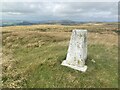
Neolithic and Bronze AgeSite Name: Merryton Low 2Country: England County: Staffordshire Type: Round Barrow(s)
Map Ref: SK040607 Landranger Map Number: 119
Latitude: 53.143433N Longitude: 1.941655W
Condition:
| 5 | Perfect |
| 4 | Almost Perfect |
| 3 | Reasonable but with some damage |
| 2 | Ruined but still recognisable as an ancient site |
| 1 | Pretty much destroyed, possibly visible as crop marks |
| 0 | No data. |
| -1 | Completely destroyed |
| 5 | Superb |
| 4 | Good |
| 3 | Ordinary |
| 2 | Not Good |
| 1 | Awful |
| 0 | No data. |
| 5 | Can be driven to, probably with disabled access |
| 4 | Short walk on a footpath |
| 3 | Requiring a bit more of a walk |
| 2 | A long walk |
| 1 | In the middle of nowhere, a nightmare to find |
| 0 | No data. |
| 5 | co-ordinates taken by GPS or official recorded co-ordinates |
| 4 | co-ordinates scaled from a detailed map |
| 3 | co-ordinates scaled from a bad map |
| 2 | co-ordinates of the nearest village |
| 1 | co-ordinates of the nearest town |
| 0 | no data |
Internal Links:
External Links:
I have visited· I would like to visit
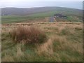
RichardKM visited on 1st Nov 2018 - their rating: Cond: 1 Amb: 2 Access: 3 After the devastating fire on Merryton Low, the vegetation was burnt down to the bare peat. The rain that preceded our visits in November and December 2018 made the ground into a quagmire, but the barrow was at least visible. The barrow is not in good condition, with signs of the army's use of the area: tyre tracks and slit trenches around it, which is not surprising, given the location being marked wrongly in the HER. However, since the site has now been properly surveyed, it should be better protected in the future.
BrownEdger visited on 1st Apr 2013 - their rating: Cond: 3 Amb: 3 Access: 4 Very narrow for a barrow
Average ratings for this site from all visit loggers: Condition: 2 Ambience: 2.5 Access: 3.5
")
Have you visited this site? Please add a comment below.
You may be viewing yesterday's version of this page. To see the most up to date information please register for a free account.
")
")
")
Do not use the above information on other web sites or publications without permission of the contributor.
Nearby Images from Geograph Britain and Ireland:
©2014(licence)
©2014(licence)
©2019(licence)
©2019(licence)
©2022(licence)
The above images may not be of the site on this page, they are loaded from Geograph.
Please Submit an Image of this site or go out and take one for us!
Click here to see more info for this site
Nearby sites
Key: Red: member's photo, Blue: 3rd party photo, Yellow: other image, Green: no photo - please go there and take one, Grey: site destroyed
Download sites to:
KML (Google Earth)
GPX (GPS waypoints)
CSV (Garmin/Navman)
CSV (Excel)
To unlock full downloads you need to sign up as a Contributory Member. Otherwise downloads are limited to 50 sites.
Turn off the page maps and other distractions
Nearby sites listing. In the following links * = Image available
316m NNE 18° Merryton Low 1* Round Barrow(s) (SK041610)
2.4km SSE 152° Elkstone Barrow 1* Round Barrow(s) (SK05155855)
2.5km SSE 151° Elkstone Barrow 2 Round Barrow(s) (SK052585)
2.6km NW 310° The Winking Man* Natural Stone / Erratic / Other Natural Feature (SK0202162362)
2.9km SW 216° Thorncliffe Barrow Round Barrow(s) (SK023584)
3.4km WNW 291° Sainter's Circle* Stone Circle (SK008619)
3.4km WNW 292° Bawd Stone* Natural Stone / Erratic / Other Natural Feature (SK0079561976)
3.6km WNW 288° The Roaches* Natural Stone / Erratic / Other Natural Feature (SK006618)
3.7km W 265° Leekfrith Tumulus* Round Barrow(s) (SK003604)
4.0km W 266° Leekfrith Stone* Standing Stone (Menhir) (SK000604)
4.0km NNW 327° The Bald Stone* Natural Stone / Erratic / Other Natural Feature (SK018641)
4.5km SE 125° Brown Low (staffs)* Round Barrow(s) (SK077581)
4.8km NW 306° Sainter's Dolmen* Rock Outcrop (SK00106357)
5.0km NW 309° The Roaches Barrow Round Barrow(s) (SK001639)
5.1km ESE 111° Blake Low* Round Barrow(s) (SK088589)
5.4km ENE 63° Booth Low 1* Round Barrow(s) (SK088631)
5.4km ENE 65° Booth Low 2* Round Barrow(s) (SK089630)
5.4km ENE 67° Booth Low 3 Round Barrow(s) (SK090628)
5.6km ESE 115° Warslow Bowl Barrow* Round Barrow(s) (SK09075837)
5.7km ESE 109° The Cops* Round Barrow(s) (SK0944358817)
5.9km WSW 250° Nine Pins* Stone Circle (SJ984587)
6.0km NNE 22° Coatestown Barrow Round Barrow(s) (SK063663)
6.2km SSE 150° Hurst Low* Round Barrow(s) (SK071553)
6.3km SSE 151° Grindon Moor Barrow* Round Barrow(s) (SK071552)
6.4km E 80° Brund Low* Round Barrow(s) (SK103618)
View more nearby sites and additional images


 We would like to know more about this location. Please feel free to add a brief description and any relevant information in your own language.
 Wir möchten mehr über diese Stätte erfahren. Bitte zögern Sie nicht, eine kurze Beschreibung und relevante Informationen in Deutsch hinzuzufügen.
 Nous aimerions en savoir encore un peu sur les lieux. S'il vous plaît n'hesitez pas à ajouter une courte description et tous les renseignements pertinents dans votre propre langue.
 Quisieramos informarnos un poco más de las lugares. No dude en añadir una breve descripción y otros datos relevantes en su propio idioma.