


<< Our Photo Pages >> Paines Bridge, Wallington C - Rock Art in England in Northumberland
Submitted by SolarMegalith on Saturday, 22 June 2013 Page Views: 2401
Rock ArtSite Name: Paines Bridge, Wallington C Alternative Name: ERA-1593; Beckensall 685Country: England County: Northumberland Type: Rock Art
Nearest Town: Morpeth Nearest Village: Wallington
Map Ref: NZ0335683905
Latitude: 55.149476N Longitude: 1.948882W
Condition:
| 5 | Perfect |
| 4 | Almost Perfect |
| 3 | Reasonable but with some damage |
| 2 | Ruined but still recognisable as an ancient site |
| 1 | Pretty much destroyed, possibly visible as crop marks |
| 0 | No data. |
| -1 | Completely destroyed |
| 5 | Superb |
| 4 | Good |
| 3 | Ordinary |
| 2 | Not Good |
| 1 | Awful |
| 0 | No data. |
| 5 | Can be driven to, probably with disabled access |
| 4 | Short walk on a footpath |
| 3 | Requiring a bit more of a walk |
| 2 | A long walk |
| 1 | In the middle of nowhere, a nightmare to find |
| 0 | No data. |
| 5 | co-ordinates taken by GPS or official recorded co-ordinates |
| 4 | co-ordinates scaled from a detailed map |
| 3 | co-ordinates scaled from a bad map |
| 2 | co-ordinates of the nearest village |
| 1 | co-ordinates of the nearest town |
| 0 | no data |
Internal Links:
External Links:
I have visited· I would like to visit
Anne T visited on 29th Jul 2014 - their rating: Cond: 3 Amb: 3 Access: 4 Full visit report under 'Wallington A', as there are three boulders with rock art within 2 metres of each other in the same location. Worth a visit if you pass over Paine's Bridge or are visiting Wallington House.
SolarMegalith visited on 12th Jun 2013 - their rating: Cond: 2 Amb: 3 Access: 4
Average ratings for this site from all visit loggers: Condition: 2.5 Ambience: 3 Access: 4
")
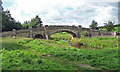
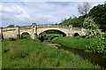
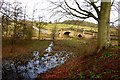
Another small boulder incorporated into the structure of Paines Bridge in Wallington. The stone bears a possible cup-mark with a groove.
For more information see England's Rock Art entry for ERA-1593 Paines Bridge, Wallington c, which includes NADRAP's notes, Beckensall's description, photographs, a sketch of the rock and its motifs, plus photogrammetry and media from the Beckensall Archive.
The original Beckensall record can be found at Internet Archive: Beckensall 685 Paines Bridge, Wallington c.
> Access to this rock art panel is by Right of Way.
You may be viewing yesterday's version of this page. To see the most up to date information please register for a free account.
")
Do not use the above information on other web sites or publications without permission of the contributor.
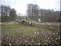
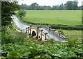
Nearby Images from Geograph Britain and Ireland:
©2011(licence)
©2013(licence)
©2013(licence)
©2014(licence)
©2020(licence)
The above images may not be of the site on this page, they are loaded from Geograph.
Please Submit an Image of this site or go out and take one for us!
Click here to see more info for this site
Nearby sites
Key: Red: member's photo, Blue: 3rd party photo, Yellow: other image, Green: no photo - please go there and take one, Grey: site destroyed
Download sites to:
KML (Google Earth)
GPX (GPS waypoints)
CSV (Garmin/Navman)
CSV (Excel)
To unlock full downloads you need to sign up as a Contributory Member. Otherwise downloads are limited to 50 sites.
Turn off the page maps and other distractions
Nearby sites listing. In the following links * = Image available
6m SW 231° Paines Bridge, Wallington B* Rock Art (NZ0335183901)
7m WSW 254° Paines Bridge, Wallington A* Rock Art (NZ0334983903)
355m E 90° Old Deanham 1 Rock Art (NZ0371283906)
588m NNW 330° Wallington Hall Standing Stone* Standing Stone (Menhir) (NZ0306584417)
1.0km NE 46° Wallington Newhouses a, b, c, d, e, f, g & N01 Rock Art (NZ0408084603)
1.6km S 189° Old Deanham a, b, c, d, e, f, g & h Rock Art (NZ03108230)
1.6km SE 128° Middleton Standing Stone (Northumberland)* Standing Stone (Menhir) (NZ04668290)
2.1km NNW 333° Jemmy's Well (Cambo)* Holy Well or Sacred Spring (NZ0240285748)
2.3km WNW 290° The Fawns (Kirkwhelpington)* Rock Art (NZ0114784698)
2.4km SE 125° Shaftoe Jubilee Stone B* Rock Art (NZ0537082515)
2.4km SE 125° Shaftoe Jubilee Stone A Rock Art (NZ0536382497)
2.5km SE 129° Shaftoe (Shaftoe Crags) Rock Art (NZ0528782365)
2.5km ESE 111° Middleton Bank Top 2a* Rock Art (NZ0571582994)
2.5km SE 128° Salters Nick Settlement* Ancient Village or Settlement (NZ05358235)
2.5km ESE 111° Middleton Bank Top 2b* Rock Art (NZ0572183000)
2.7km ESE 111° Middleton Bank Top 1b & N1b* Rock Art (NZ0583582945)
2.7km ESE 111° Middleton Bank Top 1a* Rock Art (NZ0583682943)
2.7km ESE 111° Middleton Bank Top 1c Rock Art (NZ0583882943)
2.8km SSE 150° West Shaftoe Farm N02 Rock Art (NZ0474381522)
2.8km SE 127° Salters Nick Rock Shelter Rock Art (NZ0557582243)
2.8km SSE 151° West Shaftoe Farm 1a* Rock Art (NZ0471581483)
2.8km SSE 151° West Shaftoe Farm 1b Rock Art (NZ0472681489)
2.8km SSE 150° West Shaftoe Farm N01 Rock Art (NZ0473681493)
2.8km SSE 150° West Shaftoe Farm 2b Rock Art (NZ0473581483)
2.8km SSE 150° West Shaftoe Farm 2a Rock Art (NZ0473481482)
View more nearby sites and additional images


 We would like to know more about this location. Please feel free to add a brief description and any relevant information in your own language.
 Wir möchten mehr über diese Stätte erfahren. Bitte zögern Sie nicht, eine kurze Beschreibung und relevante Informationen in Deutsch hinzuzufügen.
 Nous aimerions en savoir encore un peu sur les lieux. S'il vous plaît n'hesitez pas à ajouter une courte description et tous les renseignements pertinents dans votre propre langue.
 Quisieramos informarnos un poco más de las lugares. No dude en añadir una breve descripción y otros datos relevantes en su propio idioma.