<< Our Photo Pages >> Simonside Cairn 2 - Cairn in England in Northumberland
Submitted by Modern-Neolithic on Saturday, 13 April 2013 Page Views: 3051
Neolithic and Bronze AgeSite Name: Simonside Cairn 2Country: England County: Northumberland Type: Cairn
Nearest Village: Rothbury
Map Ref: NZ02409871
Latitude: 55.282517N Longitude: 1.963762W
Condition:
| 5 | Perfect |
| 4 | Almost Perfect |
| 3 | Reasonable but with some damage |
| 2 | Ruined but still recognisable as an ancient site |
| 1 | Pretty much destroyed, possibly visible as crop marks |
| 0 | No data. |
| -1 | Completely destroyed |
| 5 | Superb |
| 4 | Good |
| 3 | Ordinary |
| 2 | Not Good |
| 1 | Awful |
| 0 | No data. |
| 5 | Can be driven to, probably with disabled access |
| 4 | Short walk on a footpath |
| 3 | Requiring a bit more of a walk |
| 2 | A long walk |
| 1 | In the middle of nowhere, a nightmare to find |
| 0 | No data. |
| 5 | co-ordinates taken by GPS or official recorded co-ordinates |
| 4 | co-ordinates scaled from a detailed map |
| 3 | co-ordinates scaled from a bad map |
| 2 | co-ordinates of the nearest village |
| 1 | co-ordinates of the nearest town |
| 0 | no data |
Internal Links:
External Links:
I have visited· I would like to visit
Modern-Neolithic visited on 22nd May 2013 - their rating: Amb: 5 Access: 3
")
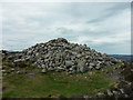
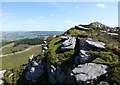
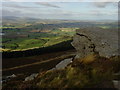
The western summit of Simonside (1408 feet above sea level) is surmounted by a large cairn. Two small modern cairns have been built from some of its stones. The cairn appears to be of some age but its purpose is not clear.
The cairn is one of two situated on the highest point of Simonside. Both are substantial curricks, but it is significant that a number of other cairns at lower levels in the vicinity yielded evidence of burials, whilst the only one comparable in size and situation to the two in question proved negative.
The cairn survives to a height in excess of 1m and has a diameter of 18m. The mound is constructed of large boulders; many of those on the surface have been re-arranged by walkers to form a modern marker cairn.
Source: NorthumberlandNationalParks
You may be viewing yesterday's version of this page. To see the most up to date information please register for a free account.
")
Do not use the above information on other web sites or publications without permission of the contributor.
Nearby Images from Geograph Britain and Ireland:
©2014(licence)
©2016(licence)
©2020(licence)
©2023(licence)
©2006(licence)
The above images may not be of the site on this page, they are loaded from Geograph.
Please Submit an Image of this site or go out and take one for us!
Click here to see more info for this site
Nearby sites
Key: Red: member's photo, Blue: 3rd party photo, Yellow: other image, Green: no photo - please go there and take one, Grey: site destroyed
Download sites to:
KML (Google Earth)
GPX (GPS waypoints)
CSV (Garmin/Navman)
CSV (Excel)
To unlock full downloads you need to sign up as a Contributory Member. Otherwise downloads are limited to 50 sites.
Turn off the page maps and other distractions
Nearby sites listing. In the following links * = Image available
363m ESE 122° Simonside Cairn 1* Cairn (NZ0271098520)
665m ESE 121° Old Stell Crag* Rock Outcrop (NZ0297498372)
833m WNW 302° Ravensheugh Cairn* Cairn (NZ0169099150)
955m W 274° Ravenshaugh Main Stone* Natural Stone / Erratic / Other Natural Feature (NZ0144598783)
1.2km N 10° Great Tosson Cairn* Cairn (NZ026999)
1.3km E 98° Dove Crag* Rock Outcrop (NZ0367898540)
1.3km E 98° Dove Crag Cairn* Cairn (NZ0372898523)
1.5km NNE 29° Great Tosson Enclosure* Ancient Village or Settlement (NU03130003)
1.8km N 358° Tosson Burgh* Hillfort (NU02340049)
1.8km NW 319° Simonside Moor Rock Art (NU0120000100)
2.1km E 93° Spy Law Beacon Cairn* Cairn (NZ04529859)
2.3km E 92° Thompson's Rock* Holed Stone (NZ0475098632)
2.5km E 82° West Lordenshaw (Birky Hill) N03 Rock Art (NZ0487999051)
2.6km E 81° Birky Hill 1c* Rock Art (NZ0500799122)
2.6km E 81° Birky Hill 1b* Rock Art (NZ0500899118)
2.6km E 81° Birky Hill 1a* Rock Art (NZ0501099119)
2.7km E 80° West Lordenshaw (Birky Hill) 1f Rock Art (NZ051992)
2.7km E 79° Birky Hill N04 Rock Art (NZ0509899218)
2.7km E 79° Birky Hill N01 Rock Art (NZ0509499241)
2.7km E 79° Birky Hill N02 Rock Art (NZ0510099217)
2.7km E 79° Lordenshaw Horseshoe Rock* Rock Art (NZ0510099223)
2.7km E 79° Birky Hill 1e* Rock Art (NZ0509799243)
2.8km E 83° West Lordenshaw 2a (i)* Rock Art (NZ0520299058)
2.8km E 83° West Lordenshaw 2a (ii)* Rock Art (NZ0520299059)
2.8km ENE 78° Birky Hill 1g Rock Art (NZ0517199300)
View more nearby sites and additional images


 We would like to know more about this location. Please feel free to add a brief description and any relevant information in your own language.
 Wir möchten mehr über diese Stätte erfahren. Bitte zögern Sie nicht, eine kurze Beschreibung und relevante Informationen in Deutsch hinzuzufügen.
 Nous aimerions en savoir encore un peu sur les lieux. S'il vous plaît n'hesitez pas à ajouter une courte description et tous les renseignements pertinents dans votre propre langue.
 Quisieramos informarnos un poco más de las lugares. No dude en añadir una breve descripción y otros datos relevantes en su propio idioma.