<< Text Pages >> Maiden Castle Barrow (Yorkshire North) - Round Barrow(s) in England in Yorkshire (North)
Submitted by coldrum on Monday, 05 December 2011 Page Views: 3807
Neolithic and Bronze AgeSite Name: Maiden Castle Barrow (Yorkshire North)Country: England County: Yorkshire (North) Type: Round Barrow(s)
Nearest Town: Healaugh
Map Ref: SE02349814
Latitude: 54.378754N Longitude: 1.965481W
Condition:
| 5 | Perfect |
| 4 | Almost Perfect |
| 3 | Reasonable but with some damage |
| 2 | Ruined but still recognisable as an ancient site |
| 1 | Pretty much destroyed, possibly visible as crop marks |
| 0 | No data. |
| -1 | Completely destroyed |
| 5 | Superb |
| 4 | Good |
| 3 | Ordinary |
| 2 | Not Good |
| 1 | Awful |
| 0 | No data. |
| 5 | Can be driven to, probably with disabled access |
| 4 | Short walk on a footpath |
| 3 | Requiring a bit more of a walk |
| 2 | A long walk |
| 1 | In the middle of nowhere, a nightmare to find |
| 0 | No data. |
| 5 | co-ordinates taken by GPS or official recorded co-ordinates |
| 4 | co-ordinates scaled from a detailed map |
| 3 | co-ordinates scaled from a bad map |
| 2 | co-ordinates of the nearest village |
| 1 | co-ordinates of the nearest town |
| 0 | no data |
Be the first person to rate this site - see the 'Contribute!' box in the right hand menu.
Internal Links:
External Links:
Round Barrow(s) in Yorkshire (North)
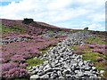
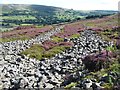
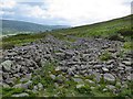
"Surveyed by the RCHME at 1:1000 in April 1996. While it is not absolutely certain that this is a cairn it seems the most likely explanation; it does not have the appearance of a natural mound or a spoil heap. The mound is 33m in diameter and up to 2.7m high maximum. It has been severely mutilated, with at least 5 pits sunk into it and 4 trenches driven in from the sides. There is some evidence of chronological depth within this barrow-digging phase as one of the holes seems to cut through the spoil from an earlier exploration. There is also evidence of a quasi-systematic approach to the ransacking of the mound, in that the pits form a line from E to W while the 2 principal trenches have been driven from opposing points on the circumference, in the SE and NW. Some of this digging pre-dates the 1820s but some may well be later."
Source: Pastscape.
You may be viewing yesterday's version of this page. To see the most up to date information please register for a free account.
Do not use the above information on other web sites or publications without permission of the contributor.
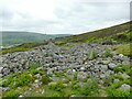
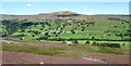
Nearby Images from Geograph Britain and Ireland:
©2023(licence)
©2016(licence)
©2016(licence)
©2016(licence)
©2018(licence)
The above images may not be of the site on this page, they are loaded from Geograph.
Please Submit an Image of this site or go out and take one for us!
Click here to see more info for this site
Nearby sites
Key: Red: member's photo, Blue: 3rd party photo, Yellow: other image, Green: no photo - please go there and take one, Grey: site destroyed
Download sites to:
KML (Google Earth)
GPX (GPS waypoints)
CSV (Garmin/Navman)
CSV (Excel)
To unlock full downloads you need to sign up as a Contributory Member. Otherwise downloads are limited to 50 sites.
Turn off the page maps and other distractions
Nearby sites listing. In the following links * = Image available
170m WSW 249° Maiden Castle (N Yorks)* Ancient Village or Settlement (SE02189808)
1.3km ESE 115° Harkerside Moor circle* Stone Circle (SE035976)
4.9km ENE 61° Whitton Burn(Rock Art) Rock Art (NZ066005)
5.8km ENE 65° Forty Acres 03 (Stelling) Rock Art (NZ07580058)
8.5km SSW 191° St Matthew's Well (Carperby)* Holy Well or Sacred Spring (SE0065689756)
8.6km SSW 191° Carperby Cross* Ancient Cross (SE0063189729)
8.7km SSW 203° Carperby Stone Circle* Stone Circle (SD99009013)
9.4km NNE 24° Frankinshaw* Cairn (NZ06170672)
9.7km NNE 17° Barningham Moor 60* Rock Art (NZ0520607422)
9.8km NNE 17° How Tallon Stone Circle* Stone Circle (NZ05150755)
9.9km NNE 20° How Tallon Cairn* Cairn (NZ05730740)
9.9km NNE 20° Barningham Moor 61 Rock Art (NZ0573907410)
9.9km NNE 17° Barningham Moor 59* Rock Art (NZ0522007624)
10.0km NNE 17° Barningham Moor 58* Rock Art (NZ0523207672)
10.0km NNE 17° Barningham Moor 89 Rock Art (NZ0534107709)
10.0km NNE 18° Barningham Moor 81 Rock Art (NZ0544307698)
10.0km NNE 18° Barningham Moor 77 Rock Art (NZ0547407695)
10.0km NNE 18° Barningham Moor 118 Rock Art (NZ0549207690)
10.1km NNE 18° Barningham Moor 95 Rock Art (NZ0551607685)
10.1km NNE 16° Barningham Moor 57* Rock Art (NZ0512907806)
10.1km NNE 18° Barningham Moor 80 Rock Art (NZ0545107708)
10.1km NNE 18° Barningham Moor 122 Rock Art (NZ0548507697)
10.1km NNE 20° Barningham Moor 137 Rock Art (NZ0575907606)
10.1km NNE 18° Barningham Moor 74 Rock Art (NZ0552607687)
10.1km NNE 18° Barningham Moor 78 Rock Art (NZ0547507704)
View more nearby sites and additional images


 We would like to know more about this location. Please feel free to add a brief description and any relevant information in your own language.
 Wir möchten mehr über diese Stätte erfahren. Bitte zögern Sie nicht, eine kurze Beschreibung und relevante Informationen in Deutsch hinzuzufügen.
 Nous aimerions en savoir encore un peu sur les lieux. S'il vous plaît n'hesitez pas à ajouter une courte description et tous les renseignements pertinents dans votre propre langue.
 Quisieramos informarnos un poco más de las lugares. No dude en añadir una breve descripción y otros datos relevantes en su propio idioma.