<< Other Photo Pages >> Wicken Hill - Misc. Earthwork in England in Yorkshire (West)
Submitted by NorthernerInLondon on Wednesday, 14 January 2015 Page Views: 3751
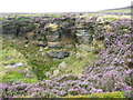
Multi-periodSite Name: Wicken Hill Alternative Name: Wiccan HillCountry: England County: Yorkshire (West) Type: Misc. Earthwork
Nearest Town: Mytholmyroyd Nearest Village: Midgley
Map Ref: SE0133527390
Latitude: 53.742888N Longitude: 1.981238W
Condition:
| 5 | Perfect |
| 4 | Almost Perfect |
| 3 | Reasonable but with some damage |
| 2 | Ruined but still recognisable as an ancient site |
| 1 | Pretty much destroyed, possibly visible as crop marks |
| 0 | No data. |
| -1 | Completely destroyed |
| 5 | Superb |
| 4 | Good |
| 3 | Ordinary |
| 2 | Not Good |
| 1 | Awful |
| 0 | No data. |
| 5 | Can be driven to, probably with disabled access |
| 4 | Short walk on a footpath |
| 3 | Requiring a bit more of a walk |
| 2 | A long walk |
| 1 | In the middle of nowhere, a nightmare to find |
| 0 | No data. |
| 5 | co-ordinates taken by GPS or official recorded co-ordinates |
| 4 | co-ordinates scaled from a detailed map |
| 3 | co-ordinates scaled from a bad map |
| 2 | co-ordinates of the nearest village |
| 1 | co-ordinates of the nearest town |
| 0 | no data |
Internal Links:
External Links:
I have visited· I would like to visit
NorthernerInLondon visited - their rating: Cond: 2 Amb: 3 Access: 4
")
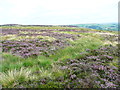
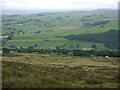
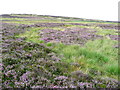
The monument includes a Bronze Age urnfield and its enclosing bank. It is situated on the edge of a natural terrace 440m north west of Rough Bottom on Midgeley Moor. The bank is subcircular, approximately 41m in diameter, 7m wide and 0.5m high. There are traces of an internal ditch, and a small earth mound near the centre of the ring. This mound was excavated in 1933 and produced half a quern. Previous excavations in 1897 had produced burnt human bone and fragments of prehistoric pottery.
Source: English Heritage
You may be viewing yesterday's version of this page. To see the most up to date information please register for a free account.
")
")
Do not use the above information on other web sites or publications without permission of the contributor.
Nearby Images from Geograph Britain and Ireland:
©2013(licence)
©2012(licence)
©2013(licence)
©2022(licence)
©2013(licence)
The above images may not be of the site on this page, they are loaded from Geograph.
Please Submit an Image of this site or go out and take one for us!
Click here to see more info for this site
Nearby sites
Key: Red: member's photo, Blue: 3rd party photo, Yellow: other image, Green: no photo - please go there and take one, Grey: site destroyed
Download sites to:
KML (Google Earth)
GPX (GPS waypoints)
CSV (Garmin/Navman)
CSV (Excel)
To unlock full downloads you need to sign up as a Contributory Member. Otherwise downloads are limited to 50 sites.
Turn off the page maps and other distractions
Nearby sites listing. In the following links * = Image available
394m WNW 283° Mount Skip (Hebden Bridge) Cairn (SE00952748)
704m ENE 65° Churn Milk Joan (Midgley Moor)* Standing Stone (Menhir) (SE0197327691)
1.1km ESE 107° Foster Clough* Misc. Earthwork (SE02352708)
1.1km NNE 31° Miller's Grave* Cairn (SE0191328369)
1.2km NNE 16° Greenwood Stone (Midgley Moor)* Marker Stone (SE0165228514)
1.3km ESE 103° Crow Hill Cairn Circle* Stone Circle (SE026271)
1.5km E 95° Midgley Moor Ring Cairn (SE0284227259)
2.6km N 4° Shore End Top Standing Stone (Menhir) (SE01533002)
2.9km ENE 70° The White Stones Natural Stone / Erratic / Other Natural Feature (SE041284)
3.0km NE 49° Sleepy Lowe Cairn (SE03612936)
3.1km N 352° High Brown Knoll* Rock Art (SE0089930463)
3.2km SSE 160° Sowerby Lad (Mytholmroyd) Standing Stone (Menhir) (SE02442443)
3.3km WNW 296° Dawson City field* Standing Stone (Menhir) (SD9837428800)
3.5km NE 36° Rocking Stone (Warley Moor) Natural Stone / Erratic / Other Natural Feature (SE0339930199)
3.5km ENE 68° Robin Hood's Penny Stone (Wainstalls) Standing Stone (Menhir) (SE04632870)
3.7km NNE 21° Dean Head Stony Edge* Rock Art (SE0267730808)
3.7km W 280° Dill Scout Standing Stone (Menhir) (SD97702806)
3.8km WSW 244° Edge End Moor* Standing Stones (SD97962572)
3.8km N 351° White Hill (Yorkshire West) Rock Art (SE0077031129)
3.9km SSW 197° Upper Lumb Cup & Ring Stone Rock Art (SE002237)
3.9km NNW 346° Clattering Edge* Rock Art (SE0036731145)
3.9km E 97° Tower Hill Enclosure Misc. Earthwork (SE05192689)
4.1km NW 312° Turn Hill Rock Art (SD9828830147)
4.3km SSW 209° Rudstoop* Standing Stone (Menhir) (SD9926923652)
4.3km ESE 108° Tower Hill (Warley) Cairn (SE05472604)
View more nearby sites and additional images


 We would like to know more about this location. Please feel free to add a brief description and any relevant information in your own language.
 Wir möchten mehr über diese Stätte erfahren. Bitte zögern Sie nicht, eine kurze Beschreibung und relevante Informationen in Deutsch hinzuzufügen.
 Nous aimerions en savoir encore un peu sur les lieux. S'il vous plaît n'hesitez pas à ajouter une courte description et tous les renseignements pertinents dans votre propre langue.
 Quisieramos informarnos un poco más de las lugares. No dude en añadir una breve descripción y otros datos relevantes en su propio idioma.