<< Text Pages >> Gled Law 6 - Rock Art in England in Northumberland
Submitted by Anne T on Thursday, 29 March 2018 Page Views: 762
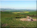
Rock ArtSite Name: Gled Law 6 Alternative Name: ERA-656; Beckensall 57Country: England County: Northumberland Type: Rock Art
Nearest Town: Wooler Nearest Village: Doddington
Map Ref: NU0087031280
Latitude: 55.575180N Longitude: 1.987761W
Condition:
| 5 | Perfect |
| 4 | Almost Perfect |
| 3 | Reasonable but with some damage |
| 2 | Ruined but still recognisable as an ancient site |
| 1 | Pretty much destroyed, possibly visible as crop marks |
| 0 | No data. |
| -1 | Completely destroyed |
| 5 | Superb |
| 4 | Good |
| 3 | Ordinary |
| 2 | Not Good |
| 1 | Awful |
| 0 | No data. |
| 5 | Can be driven to, probably with disabled access |
| 4 | Short walk on a footpath |
| 3 | Requiring a bit more of a walk |
| 2 | A long walk |
| 1 | In the middle of nowhere, a nightmare to find |
| 0 | No data. |
| 5 | co-ordinates taken by GPS or official recorded co-ordinates |
| 4 | co-ordinates scaled from a detailed map |
| 3 | co-ordinates scaled from a bad map |
| 2 | co-ordinates of the nearest village |
| 1 | co-ordinates of the nearest town |
| 0 | no data |
Be the first person to rate this site - see the 'Contribute!' box in the right hand menu.
Internal Links:
External Links:
Rock Art in Northumberland
Beckensall recorded this rock art panel as having "six cups arranged in domino patterns, similar to those found on Chatton Park Hill." NADRAP were unable to locate this panel in the field. The grid reference given above is only approximate.
For Beckensall's Archive Notes, a slide of the panel from 1989, plus a drawing, from the Beckensall Archive, see England's Rock Art entry for ERA-656 Gled Law 6.
The original Beckensall record can be found at Internet Archive: Beckensall 57 Gled Law 6.
Please note this rock art panel is located on private land.
Note: Have you located this rock art panel? Do you have an accurate grid reference, photographs or information to add?
You may be viewing yesterday's version of this page. To see the most up to date information please register for a free account.
Do not use the above information on other web sites or publications without permission of the contributor.
Nearby Images from Geograph Britain and Ireland:

©2012(licence)

©2013(licence)

©2012(licence)
©2012(licence)

©2012(licence)
The above images may not be of the site on this page, they are loaded from Geograph.
Please Submit an Image of this site or go out and take one for us!
Click here to see more info for this site
Nearby sites
Key: Red: member's photo, Blue: 3rd party photo, Yellow: other image, Green: no photo - please go there and take one, Grey: site destroyed
Download sites to:
KML (Google Earth)
GPX (GPS waypoints)
CSV (Garmin/Navman)
CSV (Excel)
To unlock full downloads you need to sign up as a Contributory Member. Otherwise downloads are limited to 50 sites.
Turn off the page maps and other distractions
Nearby sites listing. In the following links * = Image available
9m NE 41° Gled Law 5* Rock Art (NU0087631287)
171m ESE 103° Gled Law 4* Rock Art (NU0103731242)
349m NNW 348° Dod Law Enclosure Site* Rock Art (NU0079531621)
375m S 180° Gled Law N01 Rock Art (NU0087030905)
384m S 180° Gled Law 7 Rock Art (NU0087230896)
386m NNW 343° Dod Law East Hillfort (NU00763165)
390m S 180° Gled Law 10 Rock Art (NU0087030890)
486m NNW 332° Middle Dod Law* Hillfort (NU0063831708)
532m SE 141° Gled Law 3* Rock Art (NU0120730867)
555m S 177° Gled Law 2c* Rock Art (NU0089530725)
566m S 177° Gled Law 2d* Rock Art (NU0089730714)
567m S 178° Gled Law 2f* Rock Art (NU0089230713)
567m S 177° Gled Law 2b* Rock Art (NU0089730713)
568m S 178° Gled Law 2e* Rock Art (NU0088930712)
576m WSW 242° Cuddy's Cove rock art Rock Art (NU00363101)
579m NW 320° Dod Law Main Rock A* Rock Art (NU0049631723)
584m S 175° Gled Law 2a* Rock Art (NU0092130698)
586m NW 320° Dod Law Main Rock C Rock Art (NU0049631732)
586m NW 320° Dod Law Main Rock B Rock Art (NU0049531732)
621m NE 45° Doddington Moor* Stone Circle (NU01313172)
629m NW 312° Dod Law Excavation Site Objects 26, 29, 31 & 32 Rock Art (NU0040531705)
629m NW 312° Dod Law Excavation Site (Tate) Rock Art (NU0040031700)
630m NW 313° Dod Law West* Hillfort (NU0041031712)
636m NW 312° Dod Law Portable Rock Art (NU0039531705)
636m NW 311° Dod Law Cist* Rock Art (NU0039031700)
View more nearby sites and additional images


 We would like to know more about this location. Please feel free to add a brief description and any relevant information in your own language.
 Wir möchten mehr über diese Stätte erfahren. Bitte zögern Sie nicht, eine kurze Beschreibung und relevante Informationen in Deutsch hinzuzufügen.
 Nous aimerions en savoir encore un peu sur les lieux. S'il vous plaît n'hesitez pas à ajouter une courte description et tous les renseignements pertinents dans votre propre langue.
 Quisieramos informarnos un poco más de las lugares. No dude en añadir una breve descripción y otros datos relevantes en su propio idioma.