


<< Text Pages >> Dod Law Excavation Site (Tate) - Rock Art in England in Northumberland
Submitted by Anne T on Thursday, 29 March 2018 Page Views: 834
Rock ArtSite Name: Dod Law Excavation Site (Tate) Alternative Name: ERA-651; Beckensall 29Country: England County: Northumberland Type: Rock Art
Nearest Town: Wooler Nearest Village: Doddington
Map Ref: NU0040031700
Latitude: 55.578954N Longitude: 1.995215W
Condition:
| 5 | Perfect |
| 4 | Almost Perfect |
| 3 | Reasonable but with some damage |
| 2 | Ruined but still recognisable as an ancient site |
| 1 | Pretty much destroyed, possibly visible as crop marks |
| 0 | No data. |
| -1 | Completely destroyed |
| 5 | Superb |
| 4 | Good |
| 3 | Ordinary |
| 2 | Not Good |
| 1 | Awful |
| 0 | No data. |
| 5 | Can be driven to, probably with disabled access |
| 4 | Short walk on a footpath |
| 3 | Requiring a bit more of a walk |
| 2 | A long walk |
| 1 | In the middle of nowhere, a nightmare to find |
| 0 | No data. |
| 5 | co-ordinates taken by GPS or official recorded co-ordinates |
| 4 | co-ordinates scaled from a detailed map |
| 3 | co-ordinates scaled from a bad map |
| 2 | co-ordinates of the nearest village |
| 1 | co-ordinates of the nearest town |
| 0 | no data |
Internal Links:
External Links:
Rock Art in Northumberland
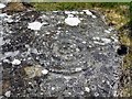
This rock art panel was first reported by Tate (no relation!), who "reports carvings on east-facing outcropping rock 6 yards north of the 'principal camp' (the hillfort). He describes these as: "three concentric circles around a cup, but the outer circle on one side curves outward, and from the second circle there comes a groove, from which another groove branches off at an angle." The Beckensall Archive notes that the groove extension is box-like, similar to that on Dod Law Excavation Site Rock A2." The original Beckensall record can be found at Internet Archive: Beckensall 29 Dod Law Excavation Site (Tate).
See England's Rock Art entry for ERA-651 Dod Law Excavation Site (Tate), which adds: "Recent field clearance is partially responsible for the movement and relocation of some rock art panels; many small clearance cairns have been noted, and where ploughed, finds of stone artefacts are recorded. Widespread Medieval and Post Medieval clearance at the scarp edges that may have also destroyed rock art panels."
Note: Have you located this rock art panel? Do you have an accurate grid reference, photographs or information to add?
You may be viewing yesterday's version of this page. To see the most up to date information please register for a free account.
Do not use the above information on other web sites or publications without permission of the contributor.
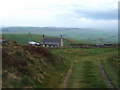
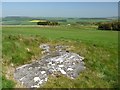
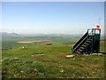
Nearby Images from Geograph Britain and Ireland:
©2009(licence)
©2012(licence)
©2012(licence)
©2012(licence)
©2011(licence)
The above images may not be of the site on this page, they are loaded from Geograph.
Please Submit an Image of this site or go out and take one for us!
Click here to see more info for this site
Nearby sites
Key: Red: member's photo, Blue: 3rd party photo, Yellow: other image, Green: no photo - please go there and take one, Grey: site destroyed
Download sites to:
KML (Google Earth)
GPX (GPS waypoints)
CSV (Garmin/Navman)
CSV (Excel)
To unlock full downloads you need to sign up as a Contributory Member. Otherwise downloads are limited to 50 sites.
Turn off the page maps and other distractions
Nearby sites listing. In the following links * = Image available
7m NE 45° Dod Law Excavation Site Objects 26, 29, 31 & 32 Rock Art (NU0040531705)
7m NW 315° Dod Law Portable Rock Art (NU0039531705)
10m W 270° Dod Law Cist* Rock Art (NU0039031700)
16m NE 40° Dod Law West* Hillfort (NU0041031712)
50m N 1° Dod Law Excavation Site 13 Rock Art (NU0040031750)
57m NNW 336° Dod Law Excavation Site B* Rock Art (NU0037731752)
60m N 1° Dod Law Excavation Site D Rock Art (NU0040131760)
63m N 355° Dod Law Excavation Site E Rock Art (NU0039431763)
65m N 1° Dod Law Excavation Site C Rock Art (NU0040131765)
74m N 3° Dod Law Excavation Site A* Rock Art (NU0040431774)
75m N 354° Dod Law Excavation Site F* Rock Art (NU0039231775)
98m ENE 77° Dod Law Main Rock A* Rock Art (NU0049631723)
100m ENE 71° Dod Law Main Rock B Rock Art (NU0049531732)
101m ENE 72° Dod Law Main Rock C Rock Art (NU0049631732)
237m E 88° Middle Dod Law* Hillfort (NU0063831708)
362m E 98° Dod Law East Hillfort (NU00763165)
402m ESE 101° Dod Law Enclosure Site* Rock Art (NU0079531621)
477m NE 53° Dod Law Quarry Site A* Rock Art (NU00783199)
608m N 351° Doddington North (Rea) Rock Art (NU0030032300)
629m SE 131° Gled Law 5* Rock Art (NU0087631287)
629m SE 132° Gled Law 6 Rock Art (NU0087031280)
668m NNW 336° Doddington North* Rock Art (NU0012432309)
691m S 183° Cuddy's Cove rock art Rock Art (NU00363101)
695m NNE 30° Dod Law Quarry Site B Rock Art (NU0075232300)
783m SE 126° Gled Law 4* Rock Art (NU0103731242)
View more nearby sites and additional images


 We would like to know more about this location. Please feel free to add a brief description and any relevant information in your own language.
 Wir möchten mehr über diese Stätte erfahren. Bitte zögern Sie nicht, eine kurze Beschreibung und relevante Informationen in Deutsch hinzuzufügen.
 Nous aimerions en savoir encore un peu sur les lieux. S'il vous plaît n'hesitez pas à ajouter une courte description et tous les renseignements pertinents dans votre propre langue.
 Quisieramos informarnos un poco más de las lugares. No dude en añadir una breve descripción y otros datos relevantes en su propio idioma.