


<< Text Pages >> Scrainwood 1. - Rock Art in England in Northumberland
Submitted by Anne T on Wednesday, 02 May 2018 Page Views: 957
Rock ArtSite Name: Scrainwood 1. Alternative Name: ERA-1552; Beckensall 654Country: England County: Northumberland Type: Rock Art
Nearest Town: Rothbury Nearest Village: Scrainwood
Map Ref: NT9984609856
Latitude: 55.382676N Longitude: 2.003981W
Condition:
| 5 | Perfect |
| 4 | Almost Perfect |
| 3 | Reasonable but with some damage |
| 2 | Ruined but still recognisable as an ancient site |
| 1 | Pretty much destroyed, possibly visible as crop marks |
| 0 | No data. |
| -1 | Completely destroyed |
| 5 | Superb |
| 4 | Good |
| 3 | Ordinary |
| 2 | Not Good |
| 1 | Awful |
| 0 | No data. |
| 5 | Can be driven to, probably with disabled access |
| 4 | Short walk on a footpath |
| 3 | Requiring a bit more of a walk |
| 2 | A long walk |
| 1 | In the middle of nowhere, a nightmare to find |
| 0 | No data. |
| 5 | co-ordinates taken by GPS or official recorded co-ordinates |
| 4 | co-ordinates scaled from a detailed map |
| 3 | co-ordinates scaled from a bad map |
| 2 | co-ordinates of the nearest village |
| 1 | co-ordinates of the nearest town |
| 0 | no data |
Be the first person to rate this site - see the 'Contribute!' box in the right hand menu.
Internal Links:
External Links:
Rock Art in Northumberland
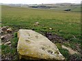
NADRAP describes this panel as being on an irregular diamond-lozenge shaped stone with a range of motifs. Motifs include a number of individual cup marks, with other cups linked by and linking grooves. The panel might be reminiscent, but larger in scale, of a cist stone with rock art. It is not known if this stone is at its original location or from a more recent field clearance.
For more information see England's Rock Art entry for ERA-1552 Scrainwood 1, which includes NADRAP's notes, Beckensall's description, photographs, a panoramic photographs, a sketch of the rock and its motifs, photogrammetry, a VRML model, a QTVR model and media from the Beckensall Archive.
The original Beckensall record can be found at Internet Archive: Beckensall 654 Scrainwood 1.
Please note this rock art panel is located on private land.
Note: Have you seen this rock art panel? Do you have any photographs or information to add?
You may be viewing yesterday's version of this page. To see the most up to date information please register for a free account.
Do not use the above information on other web sites or publications without permission of the contributor.
Nearby Images from Geograph Britain and Ireland:
©2009(licence)
©2009(licence)

©2009(licence)

©2009(licence)
©2009(licence)
The above images may not be of the site on this page, they are loaded from Geograph.
Please Submit an Image of this site or go out and take one for us!
Click here to see more info for this site
Nearby sites
Key: Red: member's photo, Blue: 3rd party photo, Yellow: other image, Green: no photo - please go there and take one, Grey: site destroyed
Download sites to:
KML (Google Earth)
GPX (GPS waypoints)
CSV (Garmin/Navman)
CSV (Excel)
To unlock full downloads you need to sign up as a Contributory Member. Otherwise downloads are limited to 50 sites.
Turn off the page maps and other distractions
Nearby sites listing. In the following links * = Image available
103m NNE 30° Scrainwood Quarry 0 & N01 Rock Art (NT9989809945)
251m SW 222° Scrainwood 3 Rock Art (NT9967809669)
254m SW 222° Scrainwood 4 Rock Art (NT9967609667)
258m SW 222° Scrainwood 5 Rock Art (NT9967309664)
277m ESE 118° Scrainwood 6 Rock Art (NU0009109725)
408m WSW 251° Scrainwood 8 & 9 Rock Art (NT9946009720)
465m SSW 207° Scrainwood 2 Rock Art (NT9963209442)
718m SE 139° Scrainwood 7 Rock Art (NU0031409310)
1.4km NW 326° Alnham* Ancient Cross (NT99081098)
2.1km WNW 300° Castle Hill (Northumberland)* Hillfort (NT98001094)
2.3km NW 323° Alnham Northfield Rock Art (NT9847911668)
3.3km ENE 77° Yetlington Lane Rock Art (NU0311010600)
4.4km WSW 248° Biddlestone* Ancient Cross (NT9574208230)
4.5km NE 35° Chubden Camp* Ancient Village or Settlement (NU02431353)
4.8km NNE 18° Wether Hill* Hillfort (NU013144)
4.8km N 7° Little Cleugh Hillfort (NU004146)
4.8km NNE 29° Old Fawdon Hill* Hillfort (NU022141)
5.0km WSW 251° Biddlestone N01 Rock Art (NT9514008211)
5.0km WSW 251° Biddlestone 1 Rock Art (NT9511508208)
5.1km WSW 241° Biddlestone Stone Circle Stone Circle (NT954074)
5.1km ESE 102° Tinkler's Dene Hillfort (NU04890881)
5.1km NNW 344° Prendwick Chesters Hillfort (NT984148)
5.2km N 8° Haystack Hill (Ingram)* Ancient Village or Settlement (NU00581505)
5.4km N 8° North Haystack Hill* Ancient Village or Settlement (NU00581521)
5.5km NE 38° Gibbs Hill* Hillfort (NU032142)
View more nearby sites and additional images


 We would like to know more about this location. Please feel free to add a brief description and any relevant information in your own language.
 Wir möchten mehr über diese Stätte erfahren. Bitte zögern Sie nicht, eine kurze Beschreibung und relevante Informationen in Deutsch hinzuzufügen.
 Nous aimerions en savoir encore un peu sur les lieux. S'il vous plaît n'hesitez pas à ajouter une courte description et tous les renseignements pertinents dans votre propre langue.
 Quisieramos informarnos un poco más de las lugares. No dude en añadir una breve descripción y otros datos relevantes en su propio idioma.