<< Text Pages >> Maiden Well (Northumberland) - Holy Well or Sacred Spring in England in Northumberland
Submitted by coldrum on Monday, 05 December 2011 Page Views: 5553
Springs and Holy WellsSite Name: Maiden Well (Northumberland)Country: England County: Northumberland Type: Holy Well or Sacred Spring
Nearest Town: Wooler
Map Ref: NT9866427082
Latitude: 55.537458N Longitude: 2.022726W
Condition:
| 5 | Perfect |
| 4 | Almost Perfect |
| 3 | Reasonable but with some damage |
| 2 | Ruined but still recognisable as an ancient site |
| 1 | Pretty much destroyed, possibly visible as crop marks |
| 0 | No data. |
| -1 | Completely destroyed |
| 5 | Superb |
| 4 | Good |
| 3 | Ordinary |
| 2 | Not Good |
| 1 | Awful |
| 0 | No data. |
| 5 | Can be driven to, probably with disabled access |
| 4 | Short walk on a footpath |
| 3 | Requiring a bit more of a walk |
| 2 | A long walk |
| 1 | In the middle of nowhere, a nightmare to find |
| 0 | No data. |
| 5 | co-ordinates taken by GPS or official recorded co-ordinates |
| 4 | co-ordinates scaled from a detailed map |
| 3 | co-ordinates scaled from a bad map |
| 2 | co-ordinates of the nearest village |
| 1 | co-ordinates of the nearest town |
| 0 | no data |
Be the first person to rate this site - see the 'Contribute!' box in the right hand menu.
Internal Links:
External Links:
Holy Well or Sacred Spring in Northumberland
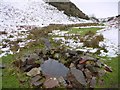
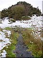
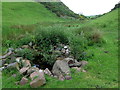
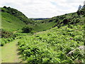
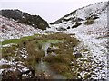
"In a ravine at the base of Kettle Hill there is a well which was formerly visited every May day by young and old, who dropped in a crooked pin and wished a wish. This well was known as the Maiden Well.
The author of 'Highways and Byways in Northumberland' (1920) reports "Wooler has a wishing-well which is sometimes described as a monument of dead superstition, but the last time I was there the number of crooked pins dropped into the well and lying under its clear water indicated that the old beliefs had not yet died out"."
Source: Pastscape.
You may be viewing yesterday's version of this page. To see the most up to date information please register for a free account.
Do not use the above information on other web sites or publications without permission of the contributor.
Nearby Images from Geograph Britain and Ireland:
©2010(licence)
©2010(licence)
©2019(licence)
©2019(licence)
©2010(licence)
The above images may not be of the site on this page, they are loaded from Geograph.
Please Submit an Image of this site or go out and take one for us!
Click here to see more info for this site
Nearby sites
Key: Red: member's photo, Blue: 3rd party photo, Yellow: other image, Green: no photo - please go there and take one, Grey: site destroyed
Download sites to:
KML (Google Earth)
GPX (GPS waypoints)
CSV (Garmin/Navman)
CSV (Excel)
To unlock full downloads you need to sign up as a Contributory Member. Otherwise downloads are limited to 50 sites.
Turn off the page maps and other distractions
Nearby sites listing. In the following links * = Image available
104m WSW 254° Maiden Well (Kettle Hill)* Holy Well or Sacred Spring (NT9856427053)
291m NW 318° The Kettles (Wooler)* Hillfort (NT98472730)
909m NNW 328° Green Castle Ringwork* Misc. Earthwork (NT9818027853)
937m NNW 329° Green Castle 2 Rock Art (NT9818227887)
1.2km NW 317° Green Castle 1 Rock Art (NT9784227949)
1.2km NNE 32° Wooler Cottage Wall Rock Art (NT993281)
1.4km N 353° Highburn House 1 Rock Art (NT9849128424)
1.5km N 10° Tankerville Arms Hotel Cist* Cist (NT9894328604)
1.6km NNE 12° Tankerville Arms Cist* Cist (NT990286)
2.1km WSW 240° Hart Heugh* Stone Circle (NT968260)
2.2km E 94° Coldmartin Tower Rock Art (NU0090026910)
2.3km WNW 301° Humbleton Hill* Hillfort (NT9670628252)
2.4km ENE 72° Coldmartin 3 Rock Art (NU0095827816)
2.4km ENE 72° Coldmartin 2* Rock Art (NU0097627830)
2.5km ENE 68° Coldmartin 4* Rock Art (NU0100628049)
2.5km ENE 68° Coldmartin 1* Rock Art (NU0103428019)
2.6km SW 214° Carey Burn (Harthope Valley)* Ancient Village or Settlement (NT97172491)
2.8km NNE 32° Weetwood Bridge Portable Rock Art (NU0018029500)
2.9km ENE 74° Whitsunbank 1b* Rock Art (NU0143827898)
2.9km ENE 73° Whitsunbank 1a* Rock Art (NU0143827909)
2.9km ENE 65° Weetwood Moor North ab, ad & ae Rock Art (NU0130028300)
2.9km ENE 65° Weetwood Moor North B* Rock Art (NU0132028328)
2.9km ENE 65° Weetwood Moor North C Rock Art (NU0132628329)
2.9km ENE 65° Weetwood Moor North aa Rock Art (NU0132628334)
2.9km ENE 65° Weetwood Moor North ac Rock Art (NU0133028328)
View more nearby sites and additional images


 We would like to know more about this location. Please feel free to add a brief description and any relevant information in your own language.
 Wir möchten mehr über diese Stätte erfahren. Bitte zögern Sie nicht, eine kurze Beschreibung und relevante Informationen in Deutsch hinzuzufügen.
 Nous aimerions en savoir encore un peu sur les lieux. S'il vous plaît n'hesitez pas à ajouter une courte description et tous les renseignements pertinents dans votre propre langue.
 Quisieramos informarnos un poco más de las lugares. No dude en añadir una breve descripción y otros datos relevantes en su propio idioma.