


<< Our Photo Pages >> Fairies Chest (Embsay Moor) - Natural Stone / Erratic / Other Natural Feature in England in Yorkshire (North)
Submitted by Anne T on Monday, 16 October 2017 Page Views: 2203
Natural PlacesSite Name: Fairies Chest (Embsay Moor) Alternative Name: Fairy's ChestCountry: England County: Yorkshire (North) Type: Natural Stone / Erratic / Other Natural Feature
Nearest Town: Skipton Nearest Village: Embsay
Map Ref: SD9869656105
Latitude: 54.000973N Longitude: 2.021383W
Condition:
| 5 | Perfect |
| 4 | Almost Perfect |
| 3 | Reasonable but with some damage |
| 2 | Ruined but still recognisable as an ancient site |
| 1 | Pretty much destroyed, possibly visible as crop marks |
| 0 | No data. |
| -1 | Completely destroyed |
| 5 | Superb |
| 4 | Good |
| 3 | Ordinary |
| 2 | Not Good |
| 1 | Awful |
| 0 | No data. |
| 5 | Can be driven to, probably with disabled access |
| 4 | Short walk on a footpath |
| 3 | Requiring a bit more of a walk |
| 2 | A long walk |
| 1 | In the middle of nowhere, a nightmare to find |
| 0 | No data. |
| 5 | co-ordinates taken by GPS or official recorded co-ordinates |
| 4 | co-ordinates scaled from a detailed map |
| 3 | co-ordinates scaled from a bad map |
| 2 | co-ordinates of the nearest village |
| 1 | co-ordinates of the nearest town |
| 0 | no data |
Be the first person to rate this site - see the 'Contribute!' box in the right hand menu.
Internal Links:
External Links:
 (PID:211650)")
The Northern Antiquarian (TNA) features a page on what they describe as "an awesome beast!" - see their entry for Fairies Chest, Embsay Moor, North Yorkshire.
TNA give us directions for finding the Fairies Chest/Fairy's Chest rock outcrop, together with a brief archaeology & history and local folklore. They describe this giant elongated boulder as being forty feet long and nearly the same size as the Hitching Stone nestled below the cliffs.
This legendary rock, and the stones around it, can be clearly seen on Google Earth and UK Grid Reference Finder.
Note: Have you visited this site? Do you have any photographs or more information to add?
You may be viewing yesterday's version of this page. To see the most up to date information please register for a free account.
 (PID:211652)")
 (PID:211651)")
 (PID:211649)")
Do not use the above information on other web sites or publications without permission of the contributor.
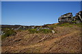
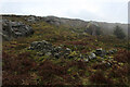
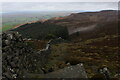
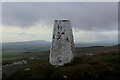
Nearby Images from Geograph Britain and Ireland:
©2011(licence)
©2020(licence)

©2007(licence)
©2020(licence)
©2020(licence)
The above images may not be of the site on this page, they are loaded from Geograph.
Please Submit an Image of this site or go out and take one for us!
Click here to see more info for this site
Nearby sites
Key: Red: member's photo, Blue: 3rd party photo, Yellow: other image, Green: no photo - please go there and take one, Grey: site destroyed
Download sites to:
KML (Google Earth)
GPX (GPS waypoints)
CSV (Garmin/Navman)
CSV (Excel)
To unlock full downloads you need to sign up as a Contributory Member. Otherwise downloads are limited to 50 sites.
Turn off the page maps and other distractions
Nearby sites listing. In the following links * = Image available
790m WNW 287° Nettlehole Ridge* Stone Circle (SD97945634)
1.8km WNW 295° Scale House (Rylstone) Cairn (SD9708856870)
2.4km W 263° Rough Haw (Flasby) Hillfort (SD963558)
2.8km SW 232° Skyrakes West (Stirton) Rock Art (SD965544)
3.1km NNW 331° St Peter's Church (Rylstone) Ancient Cross (SD972588)
4.4km S 176° Craven Museum* Museum (SD9902451734)
4.4km ESE 118° Eastby 01 (Low Lane) Rock Art (SE026540)
4.5km ESE 115° Eastby 02 (Bark Lane) Rock Art (SE02835421)
4.9km SE 126° St Helen's Well (Draughton) Holy Well or Sacred Spring (SE02705324)
5.4km WSW 241° Kirk Sink (Gargrave) Ancient Village or Settlement (SD9396753517)
5.6km S 171° Great Wood Laithe (19) Rock Art (SD9962050551)
5.7km W 279° St Helen's Well (Eshton)* Holy Well or Sacred Spring (SD9309656992)
5.7km S 170° Horse Close Hill (Skipton) Ancient Village or Settlement (SD9965350468)
5.9km WSW 250° Roman Ford (Gargrave)* Ancient Trackway (SD9316354086)
5.9km NNE 21° Ebolton Cave* Cave or Rock Shelter (SE008616)
5.9km WSW 248° St Andrew (Gargrave)* Ancient Cross (SD93205391)
6.0km SW 219° Broughton Circle Stone Circle (SD9490551404)
6.1km WSW 247° The Garris* Ancient Village or Settlement (SD9306153776)
6.2km S 172° High Laithe Stone (17) Rock Art (SD9951649914)
6.4km S 174° Low Snaygill Stone (Skipton) Rock Art (SD9939949729)
7.0km NE 40° Burnsall Crosses* Ancient Cross (SE032615)
7.3km NNE 14° The Linton Stones* Natural Stone / Erratic / Other Natural Feature (SE0042763177)
7.3km NNE 14° Linton Churchyard Cross* Ancient Cross (SE0053963220)
8.2km N 357° Little Wood* Ancient Village or Settlement (SD98266429)
8.3km W 279° Lower Colgarth Hill Tumulus* Round Barrow(s) (SD9048157360)
View more nearby sites and additional images


 We would like to know more about this location. Please feel free to add a brief description and any relevant information in your own language.
 Wir möchten mehr über diese Stätte erfahren. Bitte zögern Sie nicht, eine kurze Beschreibung und relevante Informationen in Deutsch hinzuzufügen.
 Nous aimerions en savoir encore un peu sur les lieux. S'il vous plaît n'hesitez pas à ajouter une courte description et tous les renseignements pertinents dans votre propre langue.
 Quisieramos informarnos un poco más de las lugares. No dude en añadir una breve descripción y otros datos relevantes en su propio idioma.