<< Our Photo Pages >> Eastwood Old Hall - Rock Art in England in Yorkshire (West)
Submitted by DavidShepherd on Friday, 30 August 2013 Page Views: 3204
Rock ArtSite Name: Eastwood Old Hall Alternative Name: Upper EastwoodCountry: England County: Yorkshire (West) Type: Rock Art
Map Ref: SD9602425866
Latitude: 53.729175N Longitude: 2.061743W
Condition:
| 5 | Perfect |
| 4 | Almost Perfect |
| 3 | Reasonable but with some damage |
| 2 | Ruined but still recognisable as an ancient site |
| 1 | Pretty much destroyed, possibly visible as crop marks |
| 0 | No data. |
| -1 | Completely destroyed |
| 5 | Superb |
| 4 | Good |
| 3 | Ordinary |
| 2 | Not Good |
| 1 | Awful |
| 0 | No data. |
| 5 | Can be driven to, probably with disabled access |
| 4 | Short walk on a footpath |
| 3 | Requiring a bit more of a walk |
| 2 | A long walk |
| 1 | In the middle of nowhere, a nightmare to find |
| 0 | No data. |
| 5 | co-ordinates taken by GPS or official recorded co-ordinates |
| 4 | co-ordinates scaled from a detailed map |
| 3 | co-ordinates scaled from a bad map |
| 2 | co-ordinates of the nearest village |
| 1 | co-ordinates of the nearest town |
| 0 | no data |
Internal Links:
External Links:
")
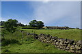
4 cup marks. On wall beside a stile. One cup is suspect.
You may be viewing yesterday's version of this page. To see the most up to date information please register for a free account.
Do not use the above information on other web sites or publications without permission of the contributor.
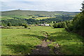
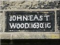
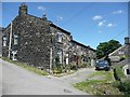
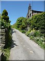
Nearby Images from Geograph Britain and Ireland:
©2013(licence)
©2010(licence)
©2010(licence)
©2010(licence)
©2013(licence)
The above images may not be of the site on this page, they are loaded from Geograph.
Please Submit an Image of this site or go out and take one for us!
Click here to see more info for this site
Nearby sites
Key: Red: member's photo, Blue: 3rd party photo, Yellow: other image, Green: no photo - please go there and take one, Grey: site destroyed
Download sites to:
KML (Google Earth)
GPX (GPS waypoints)
CSV (Garmin/Navman)
CSV (Excel)
To unlock full downloads you need to sign up as a Contributory Member. Otherwise downloads are limited to 50 sites.
Turn off the page maps and other distractions
Nearby sites listing. In the following links * = Image available
1.2km NNW 331° Staups Moor Standing Stones (SD95452692)
1.6km WSW 257° The Frying Pan 2* Cairn (SD9445425507)
1.7km WSW 255° The Frying Pan 1* Cairn (SD9433425426)
1.9km E 94° Edge End Moor* Standing Stones (SD97962572)
2.1km SE 143° Stoodley Pike Circle (Mankinholes) Ring Cairn (SD97302420)
2.5km W 270° Whirlaw Stones* Rock Art (SD9348125886)
2.8km NE 37° Dill Scout Standing Stone (Menhir) (SD97702806)
2.8km WNW 288° The Bridestones (Todmorden)* Natural Stone / Erratic / Other Natural Feature (SD9332926737)
2.9km SSE 157° Higher Moor Rock Art (SD9714223215)
2.9km W 280° Harley Wood Edge Rock Art (SD9312526386)
3.0km WSW 241° Holy Well (Todmorden)* Holy Well or Sacred Spring (SD9339324411)
3.0km SSE 151° Harry Edge* Rock Art (SD9749623216)
3.1km SSE 158° Te Deum Stone* Marker Stone (SD97202300)
3.2km WNW 282° Golden Stones (Todmorden)* Rock Outcrop (SD9291926545)
3.3km S 173° Bald Scout Hill* Rock Art (SD9642222612)
3.5km WNW 289° Bridestones (above Cliviger Gorge)* Rock Art (SD9273026989)
3.6km N 351° New Edge Chalybeate (Colden)* Holy Well or Sacred Spring (SD9544729403)
3.8km NE 39° Dawson City field* Standing Stone (Menhir) (SD9837428800)
3.8km SSW 193° Gaddings Dam Rock Art (SD9514022123)
3.9km SE 138° Buckstones Edge* Rock Art (SD9865022990)
3.9km SE 124° Rudstoop* Standing Stone (Menhir) (SD9926923652)
4.0km WNW 292° Hawks Stones (Stansfield Moor) Natural Stone / Erratic / Other Natural Feature (SD92332735)
4.1km SE 140° Buckstones. Standing Stone (Menhir) (SD98622274)
4.1km SSE 151° Withins Moor (Calderdale West)* Rock Art (SD980223)
4.1km SSW 198° Basin Stone* Rock Art (SD9472921990)
View more nearby sites and additional images


 We would like to know more about this location. Please feel free to add a brief description and any relevant information in your own language.
 Wir möchten mehr über diese Stätte erfahren. Bitte zögern Sie nicht, eine kurze Beschreibung und relevante Informationen in Deutsch hinzuzufügen.
 Nous aimerions en savoir encore un peu sur les lieux. S'il vous plaît n'hesitez pas à ajouter une courte description et tous les renseignements pertinents dans votre propre langue.
 Quisieramos informarnos un poco más de las lugares. No dude en añadir una breve descripción y otros datos relevantes en su propio idioma.