 with our Megalithic Portal iPhone app")


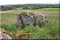
<< Our Photo Pages >> Potterton - Stone Circle in Scotland in Aberdeenshire
Submitted by cosmic on Monday, 15 July 2002 Page Views: 12144
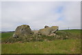
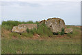
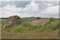
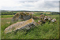
Neolithic and Bronze AgeSite Name: Potterton Alternative Name: Temple StonesCountry: Scotland County: Aberdeenshire Type: Stone Circle
Map Ref: NJ9529716365 Landranger Map Number: 38
Latitude: 57.237974N Longitude: 2.079554W
Condition:
| 5 | Perfect |
| 4 | Almost Perfect |
| 3 | Reasonable but with some damage |
| 2 | Ruined but still recognisable as an ancient site |
| 1 | Pretty much destroyed, possibly visible as crop marks |
| 0 | No data. |
| -1 | Completely destroyed |
| 5 | Superb |
| 4 | Good |
| 3 | Ordinary |
| 2 | Not Good |
| 1 | Awful |
| 0 | No data. |
| 5 | Can be driven to, probably with disabled access |
| 4 | Short walk on a footpath |
| 3 | Requiring a bit more of a walk |
| 2 | A long walk |
| 1 | In the middle of nowhere, a nightmare to find |
| 0 | No data. |
| 5 | co-ordinates taken by GPS or official recorded co-ordinates |
| 4 | co-ordinates scaled from a detailed map |
| 3 | co-ordinates scaled from a bad map |
| 2 | co-ordinates of the nearest village |
| 1 | co-ordinates of the nearest town |
| 0 | no data |
Internal Links:
External Links:
I have visited· I would like to visit
Chilli saw from a distance on 7th Jul 2020 We found another stone circle, accessed from Cairnview Rd. Climb through a wooded area, and there remain several standing most have been toppled in a very overgrown area.
Lovely rowan trees, honeysuckle, fern and moss.
")
More details in the CANMORE Record here
You may be viewing yesterday's version of this page. To see the most up to date information please register for a free account.
")
")
")
Do not use the above information on other web sites or publications without permission of the contributor.
Nearby Images from Geograph Britain and Ireland:
©2020(licence)
©2016(licence)
©2016(licence)
©2016(licence)
©2016(licence)
The above images may not be of the site on this page, they are loaded from Geograph.
Please Submit an Image of this site or go out and take one for us!
Click here to see more info for this site
Nearby sites
Key: Red: member's photo, Blue: 3rd party photo, Yellow: other image, Green: no photo - please go there and take one, Grey: site destroyed
Download sites to:
KML (Google Earth)
GPX (GPS waypoints)
CSV (Garmin/Navman)
CSV (Excel)
To unlock full downloads you need to sign up as a Contributory Member. Otherwise downloads are limited to 50 sites.
Turn off the page maps and other distractions
Nearby sites listing. In the following links * = Image available
1.3km N 9° Hare Cairn* Cairn (NJ9550417656)
3.5km SSW 202° Mundurno* Stone Circle (NJ940131)
3.5km SSW 201° Dubford Standing Stone (Menhir) (NJ9400313096)
5.5km SW 218° Whitestripes Henge (NJ919120)
7.8km W 263° Dyce Pictish Stones* Class I / Class II Hybrid Pictish Symbol Stone (NJ875154)
8.0km W 264° St Medden's Kirkyard* Class I Pictish Symbol Stone (NJ873156)
8.1km NNW 347° Hill Of Fiddes* Stone Circle (NJ934243)
8.3km S 190° King's Museum* Museum (NJ9391608216)
8.3km WNW 283° Monykebbuck* Standing Stone (Menhir) (NJ8715418291)
8.6km SSW 201° Lang Stane (Aberdeen)* Standing Stone (Menhir) (NJ922083)
9.1km WSW 239° Dyce Stones* Standing Stones (NJ87481175)
9.7km NE 35° Forvie 'Stone Circle'* Stone Circle (NK00952429)
9.8km WSW 251° Tyrebagger* Stone Circle (NJ85951322)
9.9km S 186° Tillytarmont 1* Class I Pictish Symbol Stone (NJ94280651)
10.1km S 186° Marischal Museum* Museum (NJ943063)
10.2km WSW 239° Holy Well (Chapel of Stonyewood)* Holy Well or Sacred Spring (NJ865112)
10.3km NNE 33° Forvie Sands Flint Workings* Ancient Mine, Quarry or other Industry (NK0125)
10.5km S 188° The Langstane* Standing Stone (Menhir) (NJ93770597)
10.7km WNW 297° St Mary's Well (Straloch)* Holy Well or Sacred Spring (NJ858213)
11.3km W 269° Donald's Hillock* Cairn (NJ84001609)
11.3km W 260° The Slacks* Cairn (NJ841144)
11.5km NNE 30° Forvie Hut Circles Ancient Village or Settlement (NK01072633)
11.7km W 270° Fintray Cursus Cursus (NJ83571633)
11.8km W 270° Mill of Fintray Cursus Multiple Stone Rows / Avenue (NJ835163)
11.8km NNE 30° Forvie Kerb Cairns* Cairn (NK012266)
View more nearby sites and additional images


 We would like to know more about this location. Please feel free to add a brief description and any relevant information in your own language.
 Wir möchten mehr über diese Stätte erfahren. Bitte zögern Sie nicht, eine kurze Beschreibung und relevante Informationen in Deutsch hinzuzufügen.
 Nous aimerions en savoir encore un peu sur les lieux. S'il vous plaît n'hesitez pas à ajouter une courte description et tous les renseignements pertinents dans votre propre langue.
 Quisieramos informarnos un poco más de las lugares. No dude en añadir una breve descripción y otros datos relevantes en su propio idioma.