<< Our Photo Pages >> Standing Stone Hill (Heptonstall) - Standing Stone (Menhir) in England in Yorkshire (West)
Submitted by DavidRaven on Monday, 29 November 2004 Page Views: 11262
Neolithic and Bronze AgeSite Name: Standing Stone Hill (Heptonstall)Country: England County: Yorkshire (West) Type: Standing Stone (Menhir)
Nearest Town: Hebden Bridge Nearest Village: Heptonstall
Map Ref: SD9535430190
Latitude: 53.768034N Longitude: 2.071964W
Condition:
| 5 | Perfect |
| 4 | Almost Perfect |
| 3 | Reasonable but with some damage |
| 2 | Ruined but still recognisable as an ancient site |
| 1 | Pretty much destroyed, possibly visible as crop marks |
| 0 | No data. |
| -1 | Completely destroyed |
| 5 | Superb |
| 4 | Good |
| 3 | Ordinary |
| 2 | Not Good |
| 1 | Awful |
| 0 | No data. |
| 5 | Can be driven to, probably with disabled access |
| 4 | Short walk on a footpath |
| 3 | Requiring a bit more of a walk |
| 2 | A long walk |
| 1 | In the middle of nowhere, a nightmare to find |
| 0 | No data. |
| 5 | co-ordinates taken by GPS or official recorded co-ordinates |
| 4 | co-ordinates scaled from a detailed map |
| 3 | co-ordinates scaled from a bad map |
| 2 | co-ordinates of the nearest village |
| 1 | co-ordinates of the nearest town |
| 0 | no data |
Internal Links:
External Links:
 (PID:10010)")
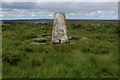
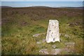
Standing Stone hill, Heptonstall Moor, has no standing stones shown on the O.S. maps, although there appear to be at least three in this area. With a little wandering, a few possible candidates for the hill's namesake can be found.
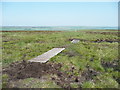
A candidate for one of the stones can be found at SD9535430190. It has an elevation of 398m, is 110cm height, 120cm long & has a thickness of 40cm. (info DavidShepherd). More information on these stones may be found in Dr. David Shepherd's paper Standing for What? Standing Stones in the South Pennines. This stone is ref 2.
This stone is also featured on The Northern Antiquarian (TNA) - see their entry for Standing Stone Hill, Heptonstall, West Yorkshire, which gives the grid reference a few metres away at SD 95355 30184. TNA gives directions for finding this stone together with photographs and a brief archaeology & history.
TNA tells us this standing stone is "Although not a tall specimen by any means, this rounded and weather-worn upright has fine character and age to it. Standing more than 3 feet in height and nearly as wide, the stone has a faded but distinct artistic carving of the letter ‘T’ on its western face (which you can make out on the photo, hopefully). It was thought this may have been an old boundary marking, but the stone ain't on any boundary line so possibly relates to some local family who marked it with that deluded notion of ‘ownership’ of this part of the desolate moors."
Describing this as a beautiful spot, TNA adds: "There are a couple of other possible standing stones on this section of moorland. One in particular appears to have been taller in bygone times and is marked on the 1851 OS-map of the region about 100 yards southwest of the triangulation pillar."
You may be viewing yesterday's version of this page. To see the most up to date information please register for a free account.
 (PID:24256)")
 (PID:10009)")
Do not use the above information on other web sites or publications without permission of the contributor.
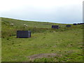
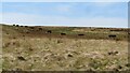
Nearby Images from Geograph Britain and Ireland:
©2015(licence)
©2022(licence)
©2016(licence)
©2016(licence)
©2005(licence)
The above images may not be of the site on this page, they are loaded from Geograph.
Please Submit an Image of this site or go out and take one for us!
Click here to see more info for this site
Nearby sites
Key: Red: member's photo, Blue: 3rd party photo, Yellow: other image, Green: no photo - please go there and take one, Grey: site destroyed
Download sites to:
KML (Google Earth)
GPX (GPS waypoints)
CSV (Garmin/Navman)
CSV (Excel)
To unlock full downloads you need to sign up as a Contributory Member. Otherwise downloads are limited to 50 sites.
Turn off the page maps and other distractions
Nearby sites listing. In the following links * = Image available
694m E 90° Pailer End Slade* Standing Stone (Menhir) (SD96053019)
792m S 173° New Edge Chalybeate (Colden)* Holy Well or Sacred Spring (SD9544729403)
812m N 356° Black Scout* Rock Art (SD9530431001)
834m N 6° King Common Rough* Standing Stone (Menhir) (SD95443102)
988m NNE 14° Graining Water Standing Stones (SD95593115)
996m W 274° Reap's Cross (Heptonstall Moor) Ancient Cross (SD9435830268)
1.2km N 358° Ridge Rough* Rock Art (SD9530831358)
1.2km N 350° Ridge Rough* Standing Stones (SD95153140)
2.7km NNW 333° The Notch* Standing Stones (SD94093262)
2.8km NNW 344° Sutcliffe Rough Standing Stone (Menhir) (SD9461132872)
2.9km E 91° Turn Hill Rock Art (SD9828830147)
2.9km NNW 347° Pisser Rough (North) Standing Stones (SD9469233048)
3.0km NNE 17° Deerstones Rock Art (SD9624233015)
3.2km SE 132° Dill Scout Standing Stone (Menhir) (SD97702806)
3.3km S 178° Staups Moor Standing Stones (SD95452692)
3.3km ESE 115° Dawson City field* Standing Stone (Menhir) (SD9837428800)
3.5km NNE 18° Walshaw Dean Reservoir* Stone Circle (SD96473355)
3.8km NNE 13° Shaw Dyke Hill* Standing Stones (SD96223388)
3.9km NW 320° Widdop Rock Art (SD9282633159)
4.0km SSW 210° The Bridestones (Todmorden)* Natural Stone / Erratic / Other Natural Feature (SD9332926737)
4.1km SW 219° Bridestones (above Cliviger Gorge)* Rock Art (SD9273026989)
4.1km SW 227° Hawks Stones (Stansfield Moor) Natural Stone / Erratic / Other Natural Feature (SD92332735)
4.4km S 171° Eastwood Old Hall* Rock Art (SD9602425866)
4.4km SSW 214° Golden Stones (Todmorden)* Rock Outcrop (SD9291926545)
4.4km SSW 210° Harley Wood Edge Rock Art (SD9312526386)
View more nearby sites and additional images


 We would like to know more about this location. Please feel free to add a brief description and any relevant information in your own language.
 Wir möchten mehr über diese Stätte erfahren. Bitte zögern Sie nicht, eine kurze Beschreibung und relevante Informationen in Deutsch hinzuzufügen.
 Nous aimerions en savoir encore un peu sur les lieux. S'il vous plaît n'hesitez pas à ajouter une courte description et tous les renseignements pertinents dans votre propre langue.
 Quisieramos informarnos un poco más de las lugares. No dude en añadir una breve descripción y otros datos relevantes en su propio idioma.