<< Text Pages >> White Law - Hillfort in England in Northumberland
Submitted by vicky on Monday, 24 March 2003 Page Views: 4942
Iron Age and Later PrehistorySite Name: White LawCountry: England County: Northumberland Type: Hillfort
Map Ref: NT949291 Landranger Map Number: 74
Latitude: 55.555564N Longitude: 2.082403W
Condition:
| 5 | Perfect |
| 4 | Almost Perfect |
| 3 | Reasonable but with some damage |
| 2 | Ruined but still recognisable as an ancient site |
| 1 | Pretty much destroyed, possibly visible as crop marks |
| 0 | No data. |
| -1 | Completely destroyed |
| 5 | Superb |
| 4 | Good |
| 3 | Ordinary |
| 2 | Not Good |
| 1 | Awful |
| 0 | No data. |
| 5 | Can be driven to, probably with disabled access |
| 4 | Short walk on a footpath |
| 3 | Requiring a bit more of a walk |
| 2 | A long walk |
| 1 | In the middle of nowhere, a nightmare to find |
| 0 | No data. |
| 5 | co-ordinates taken by GPS or official recorded co-ordinates |
| 4 | co-ordinates scaled from a detailed map |
| 3 | co-ordinates scaled from a bad map |
| 2 | co-ordinates of the nearest village |
| 1 | co-ordinates of the nearest town |
| 0 | no data |
Be the first person to rate this site - see the 'Contribute!' box in the right hand menu.
Internal Links:
External Links:
I have visited· I would like to visit
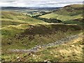
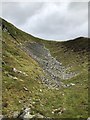
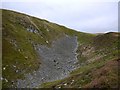
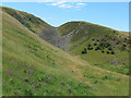
DenzilRed visited on 3rd Sep 2017 - their rating: Cond: 2 Amb: 5 Access: 3 Little remains apart from feint outline of multivallate ramparts visible on southern face. Northern face has mostly eroded but this may have used natural slope as a rampart rather than earthworks, although some stone and scree has fallen down into the valley below so earthworks may have existed.
Site is smaller than other examples in the valley, with approximately three roundhouses in the enclosure and two ramparts on the southern face. While the roundhouses and ramparts are very difficult to observe on the summit, the ramparts are visible on ascent/descent of the western ridge to the summit. The roundhouses are observed via crop marks using ariel imagery from Google Maps.
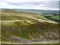
Surprisingly well sheltered from the elements and although this fort is quite high up (410m), it does offer an exceptional view of the surrounding valley, other forts and as far as the coast, giving it an excellent vantage point to spot potential invaders as well as providing some sheltered pasture for livestock.
Have you visited this site? Please add a comment below.
You may be viewing yesterday's version of this page. To see the most up to date information please register for a free account.
Do not use the above information on other web sites or publications without permission of the contributor.
Nearby Images from Geograph Britain and Ireland:
©2009(licence)
©2020(licence)
©2020(licence)
©2009(licence)
©2009(licence)
The above images may not be of the site on this page, they are loaded from Geograph.
Please Submit an Image of this site or go out and take one for us!
Click here to see more info for this site
Nearby sites
Key: Red: member's photo, Blue: 3rd party photo, Yellow: other image, Green: no photo - please go there and take one, Grey: site destroyed
Download sites to:
KML (Google Earth)
GPX (GPS waypoints)
CSV (Garmin/Navman)
CSV (Excel)
To unlock full downloads you need to sign up as a Contributory Member. Otherwise downloads are limited to 50 sites.
Turn off the page maps and other distractions
Nearby sites listing. In the following links * = Image available
141m SW 225° Gleads Cleugh Hillfort (NT948290)
920m SE 131° Harehope Hill* Hillfort (NT956285)
1.7km WSW 253° Whitelaw (Kirknewton) Rock Art (NT9330028600)
1.9km NNE 31° West Akeld Steads Henge Henge (NT95883070)
1.9km E 79° Bendor Stone* Standing Stone (Menhir) (NT9681929460)
2.0km ESE 115° Humbleton Hill* Hillfort (NT9670628252)
2.1km W 276° Yeavering Bell* Hillfort (NT92802931)
2.3km NW 304° Battle Stone (Kirknewton)* Standing Stone (Menhir) (NT92993038)
2.4km WNW 303° Old Yeavering Henge* Henge (NT92853043)
2.6km WNW 302° Ad Gefrin* Ancient Palace (NT9270630484)
2.7km NNE 17° Ewart Park Henge Henge (NT95693172)
2.8km NNE 12° Ewart Cursus Cursus (NT955318)
3.2km ESE 111° Green Castle 1 Rock Art (NT9784227949)
3.2km NNW 348° East Marleyknowe Henge Henge (NT94233226)
3.3km N 349° Milfield Cursus Cursus (NT943323)
3.4km WNW 282° St Gregory's Hill* Hillfort (NT9161329805)
3.4km NNE 17° Thirlings Ancient Village or Settlement (NT959324)
3.5km ESE 110° Green Castle 2 Rock Art (NT9818227887)
3.5km ESE 111° Green Castle Ringwork* Misc. Earthwork (NT9818027853)
3.6km W 271° Torlee House, Kirknewton Rock Art (NT9127029190)
3.6km SSE 148° Hart Heugh* Stone Circle (NT968260)
3.6km W 271° West Hill, Kirknewton* Rock Art (NT9125329199)
3.6km E 101° Highburn House 1 Rock Art (NT9849128424)
3.7km WNW 288° St. Gregory's The Great (Kirknewton)* Sculptured Stone (NT9134630251)
3.7km SW 236° Yeavering Bell Stone Circle Stone Circle (NT918270)
View more nearby sites and additional images


 We would like to know more about this location. Please feel free to add a brief description and any relevant information in your own language.
 Wir möchten mehr über diese Stätte erfahren. Bitte zögern Sie nicht, eine kurze Beschreibung und relevante Informationen in Deutsch hinzuzufügen.
 Nous aimerions en savoir encore un peu sur les lieux. S'il vous plaît n'hesitez pas à ajouter une courte description et tous les renseignements pertinents dans votre propre langue.
 Quisieramos informarnos un poco más de las lugares. No dude en añadir una breve descripción y otros datos relevantes en su propio idioma.