


<< Other Photo Pages >> Kirkcarrion - Round Barrow(s) in England in County Durham
Submitted by durhamnature on Sunday, 24 March 2013 Page Views: 6280
Neolithic and Bronze AgeSite Name: Kirkcarrion Alternative Name: Carreg Caryn; Caryn's Castle; Kirk ArranCountry: England
NOTE: This site is 1.8 km away from the location you searched for.
County: County Durham Type: Round Barrow(s)
Nearest Town: Middleton in Teesdale Nearest Village: Mickleton
Map Ref: NY9390023800
Latitude: 54.609325N Longitude: 2.095957W
Condition:
| 5 | Perfect |
| 4 | Almost Perfect |
| 3 | Reasonable but with some damage |
| 2 | Ruined but still recognisable as an ancient site |
| 1 | Pretty much destroyed, possibly visible as crop marks |
| 0 | No data. |
| -1 | Completely destroyed |
| 5 | Superb |
| 4 | Good |
| 3 | Ordinary |
| 2 | Not Good |
| 1 | Awful |
| 0 | No data. |
| 5 | Can be driven to, probably with disabled access |
| 4 | Short walk on a footpath |
| 3 | Requiring a bit more of a walk |
| 2 | A long walk |
| 1 | In the middle of nowhere, a nightmare to find |
| 0 | No data. |
| 5 | co-ordinates taken by GPS or official recorded co-ordinates |
| 4 | co-ordinates scaled from a detailed map |
| 3 | co-ordinates scaled from a bad map |
| 2 | co-ordinates of the nearest village |
| 1 | co-ordinates of the nearest town |
| 0 | no data |
Internal Links:
External Links:
I have visited· I would like to visit
SumDoood saw from a distance on 14th Jul 2017 You can park free in the old school yard next to the bridge over the Tees, and follow the Pennine Way until you choose to divert towards the site. I know this because a helpful woman in the community bookshop told me (but she did say it's a Saxon burial site). The tourist info office is open only a few hours a week. Both places are staffed by volunteers.
")
County site number D3105.
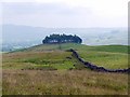
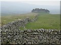
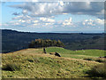
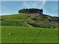
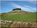
One of Durham's most scenic Bronze Age sites, on the skyline of Lunedale and Tessdale. The barrow was excavated in 1804, and was found to hold a stone-lined grave with a cremation in a pot. The barrow was partially flattened in the process, but was then partially repaired, planted with pine trees and surrounded by a dry stone wall by the landowner. The tree-covered mound is visible from across Lunedale and Teesdale.
The name is said to derive from the burial, of a local chieftain called Caryn, with the original name of the site being Carreg Caryn.
The Journal of Antiquities features a page for Kirkcarrion, Middleton-in-Teesdale, County Durham, which gives directions on how to reach this barrow, together with a description, local folklore and a photograph. Whilst the site is marked on the HE map as Kirkcarrion, there is no scheduling information, but the tumulus is recorded as Pastscape Monument No. 17772, which says the urn was originally kept at Streatlam but is now lost. A reference from 1905 says: "Cist stones are built into Crossthwaite pasture wall" although a later entry says: "The removed stone content of the cairn lies 4m to the south". The Pastscape entry only gives a 6 digit grid reference.
Update March 2026: A feature article in the Northern Echo picks up the legend of "Prince Caryn" buried in the Bronze Age round barrow at Kirkcarrion near Middleton-in-Teesdale, County Durham. In 1804 a cist burial with a funerary urn containing cremated bones was found. Lord Strathmore subsequently built walls around the mound and planted pine trees. The site overlooks Middleton-in-Teesdale from about 400 feet above on Lunedale Ridge. For more information, see:
Northern Echo, "Kirkcarrion near Mickleton linked to folklore of Bronze Age chieftain, 18th November 2025";
Fabulous North, "An ancient burial ground for a Bronze Age chieftain called Prince Caryn"; and
The Journal of Antiquities, "Kirkcarrion, Middleton-in-Teesdale, County Durham".
You may be viewing yesterday's version of this page. To see the most up to date information please register for a free account.
")
Do not use the above information on other web sites or publications without permission of the contributor.
davidmorgan has found this location on Google Street View:
Nearby Images from Geograph Britain and Ireland:
©2011(licence)
©2005(licence)
©2012(licence)
©2019(licence)
©2011(licence)
The above images may not be of the site on this page, they are loaded from Geograph.
Please Submit an Image of this site or go out and take one for us!
Click here to see more info for this site
Nearby sites
Key: Red: member's photo, Blue: 3rd party photo, Yellow: other image, Green: no photo - please go there and take one, Grey: site destroyed
Download sites to:
KML (Google Earth)
GPX (GPS waypoints)
CSV (Garmin/Navman)
CSV (Excel)
To unlock full downloads you need to sign up as a Contributory Member. Otherwise downloads are limited to 50 sites.
Turn off the page maps and other distractions
Nearby sites listing. In the following links * = Image available
3.6km SE 142° Romaldkirk Moor 3 Rock Art (NY9614820923)
3.7km S 183° Blake Hill 5 Rock Art (NY9373020146)
3.7km SE 139° Romaldkirk Moor 1 Rock Art (NY9632621055)
3.7km S 183° Blake Hill 1 Rock Art (NY9372720135)
3.7km S 183° Blake Hill 2 Rock Art (NY9373320133)
3.7km SE 137° Romaldkirk Moor 2 Rock Art (NY9640021100)
3.7km S 183° Blake Hill 3 Rock Art (NY9372320127)
3.7km S 183° Blake Hill 4 Rock Art (NY9372020115)
3.7km SSE 157° Howgill Grange 3* Rock Art (NY9536120410)
3.7km SSE 155° Howgill Grange 1.* Rock Art (NY9544620413)
3.7km SSE 162° Howgill Grange 13* Rock Art (NY9506120244)
3.7km SSE 162° Howgill Grange 11 & 12 Rock Art (NY9506020240)
3.7km SSE 160° Howgill Grange 10* Rock Art (NY9518520280)
3.7km SSE 156° Howgill Grange 2* Rock Art (NY9540820366)
3.7km S 176° Hillgill Plantation Rock Art (NY9413920057)
3.8km SSE 160° Howgill Grange 9* Rock Art (NY9517320235)
3.9km SSE 159° Howgill Grange 8* Rock Art (NY9527320193)
3.9km SSE 157° Howgill Grange 4* Rock Art (NY9541820248)
4.0km SSE 156° Howgill Grange 7* Rock Art (NY9549820167)
4.0km SSE 156° Howgill Grange 6* Rock Art (NY9553220161)
4.0km SSE 156° Howgill Grange 5* Rock Art (NY9554320142)
4.1km SSE 166° Hunderthwaite Moor 1 Rock Art (NY9485719854)
4.4km SE 127° Bracken Rigg 2* Rock Art (NY9745321132)
4.5km E 84° Swinkley Knoll* Round Barrow(s) (NY98352425)
4.5km ENE 72° Eggleston Stone Circle (NY982252)
View more nearby sites and additional images


 We would like to know more about this location. Please feel free to add a brief description and any relevant information in your own language.
 Wir möchten mehr über diese Stätte erfahren. Bitte zögern Sie nicht, eine kurze Beschreibung und relevante Informationen in Deutsch hinzuzufügen.
 Nous aimerions en savoir encore un peu sur les lieux. S'il vous plaît n'hesitez pas à ajouter une courte description et tous les renseignements pertinents dans votre propre langue.
 Quisieramos informarnos un poco más de las lugares. No dude en añadir una breve descripción y otros datos relevantes en su propio idioma.