<< Our Photo Pages >> St Mary the Virgin (Blanchland) - Ancient Cross in England in Northumberland
Submitted by Anne T on Tuesday, 10 September 2019 Page Views: 1340
Early Medieval (Dark Age)Site Name: St Mary the Virgin (Blanchland)Country: England
NOTE: This site is 3.3 km away from the location you searched for.
County: Northumberland Type: Ancient Cross
Nearest Town: Hexham Nearest Village: Blanchland
Map Ref: NY9659850408
Latitude: 54.848465N Longitude: 2.054508W
Condition:
| 5 | Perfect |
| 4 | Almost Perfect |
| 3 | Reasonable but with some damage |
| 2 | Ruined but still recognisable as an ancient site |
| 1 | Pretty much destroyed, possibly visible as crop marks |
| 0 | No data. |
| -1 | Completely destroyed |
| 5 | Superb |
| 4 | Good |
| 3 | Ordinary |
| 2 | Not Good |
| 1 | Awful |
| 0 | No data. |
| 5 | Can be driven to, probably with disabled access |
| 4 | Short walk on a footpath |
| 3 | Requiring a bit more of a walk |
| 2 | A long walk |
| 1 | In the middle of nowhere, a nightmare to find |
| 0 | No data. |
| 5 | co-ordinates taken by GPS or official recorded co-ordinates |
| 4 | co-ordinates scaled from a detailed map |
| 3 | co-ordinates scaled from a bad map |
| 2 | co-ordinates of the nearest village |
| 1 | co-ordinates of the nearest town |
| 0 | no data |
Internal Links:
External Links:
I have visited· I would like to visit
Anne T visited on 8th Sep 2019 - their rating: Cond: 3 Amb: 4 Access: 4 Churchyard Cross, Blanchland: The grid reference given by Pastscape is incorrect; theirs places it on moorland to the north west of the village. The cross is at NY 96598 50408.
Blanchland is a relatively remote, but really lovely medieval village, near the border with County Durham. The site of one of five Premonstratensian Abbeys in north-eastern England, with this church having once formed the centre of worship at the monastery here. Today, only part of the church survives, in a really unusual L-shaped form. After the Reformation, the church was left to become ruined, but was partially restored in the mid-18th century. The current building is formed from the north transept (with the tower at its northern end) and the eastern arm of the medieval Abbey church.
We have been to this church before (and occasionally to the Lord Crewe Arms next door, but more often to the White Monk Tearooms opposite). We thought that this churchyard cross was actually a modern grave marker, as it looks relatively modern, but is what Pastscape and Historic England class as "a rare survival" of a complete medieval churchyard cross.
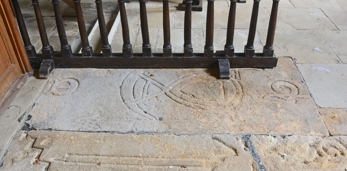
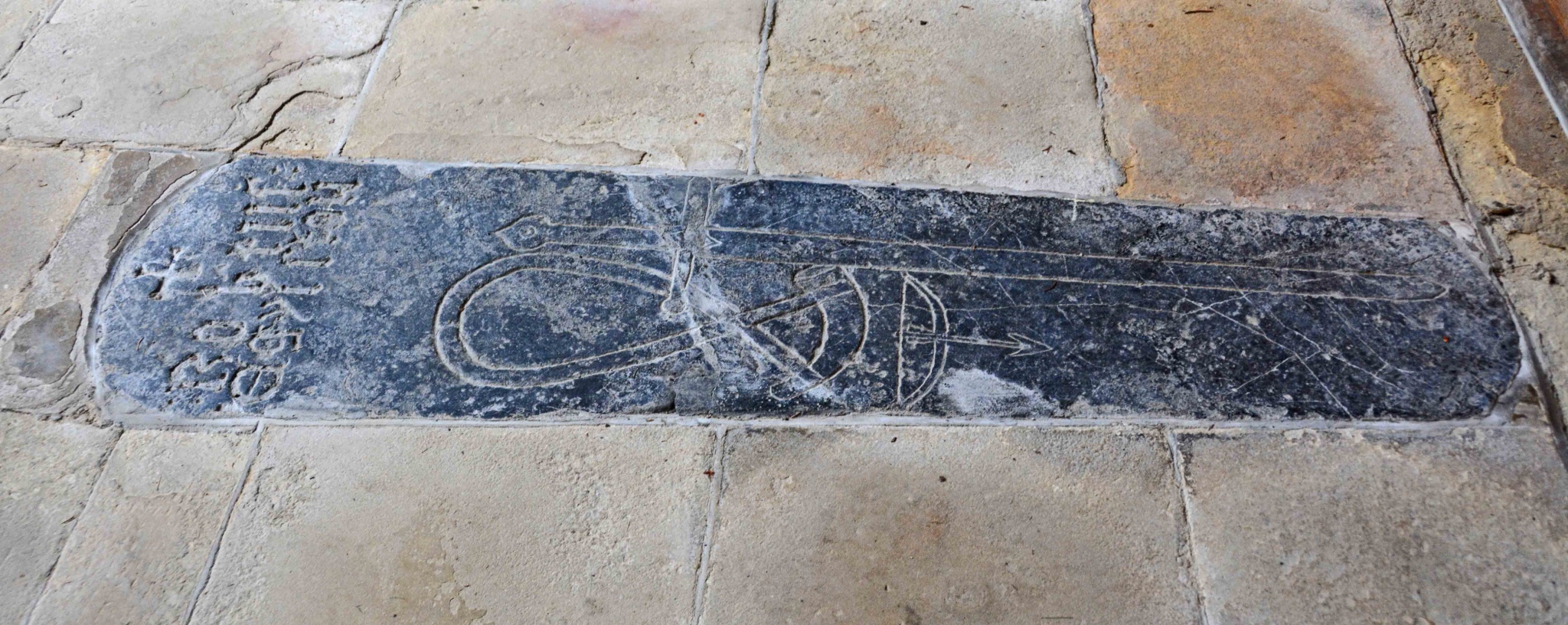
Inside, the church feels somewhat bare, but there are six interesting grave slabs set into the floor of the north transept. Peter Ryder has recorded these, saying they are "without close local parallels".
To see the eastern external walls of the church, you need to relax in the beer garden of the Lord Crewe Arms!

We have visited the beautiful medieval village of Blanchland before, but didn't realise that this cross was medieval - we thought it was a relatively modern grave marker. Recorded as Pastscape Monument No. 1318150, the cross is 17m outside the west door of the church (to your left as you approach from the main gate into the churchyard from the B6306.
Pastscape describes this cross as a rare survival of a complete medieval churchyard cross, telling us it is "probably 13th century. Gritstone. Monolithic shaft with chamfered angles with broach stops at base, bracelet cross head. Overall height 2.9m. Octagonal base now at ground level; steps probably beneath present ground level".
The cross is grade II listed by Historic England; see their entry for List ID 1045418. The notes inside the church read: "Raids by the Scots were frequent. The 13th century cross in the churchyard is a memorial to a number of monks slain in one of these raids."
The church, which used to service the Premonstratensian Abbey but left to fall into ruins, was brought back into use as a Parish Church in 1752. It is recorded as Pastscape Monument No. 1318140 and Grade I listed as Historic England List ID 1304226.
Inside the church, set into the north transept floor, are six unusual medieval grave slabs. Recorded and drawn by Peter Ryder, local Historic Buildings Consultant. His architectural assessment of the church is available at the Diocese of Newcastle website: Blanchland (St Mary The Virgin).
You may be viewing yesterday's version of this page. To see the most up to date information please register for a free account.


Do not use the above information on other web sites or publications without permission of the contributor.
Click here to see more info for this site
Nearby sites
Key: Red: member's photo, Blue: 3rd party photo, Yellow: other image, Green: no photo - please go there and take one, Grey: site destroyed
Download sites to:
KML (Google Earth)
GPX (GPS waypoints)
CSV (Garmin/Navman)
CSV (Excel)
To unlock full downloads you need to sign up as a Contributory Member. Otherwise downloads are limited to 50 sites.
Turn off the page maps and other distractions
Nearby sites listing. In the following links * = Image available
2.8km S 183° Old Man's Grave (Edmunbyers)* Marker Stone (NY96464763)
4.7km SSW 214° Hunstanworth Moor north* Standing Stone (Menhir) (NY9398546500)
5.2km S 173° Dead Friar's Stone (Stanhope)* Marker Stone (NY9721545194)
5.3km SSW 212° Hunstanworth Moor south* Standing Stone (Menhir) (NY9377745971)
6.8km SE 146° Edmundbyers Cross (Muggleswick)* Ancient Cross (NZ0040244761)
7.4km SSE 153° Feldon Plain (Muggleswick)* Marker Stone (NY9988843816)
8.2km NE 48° St George's Well (Minsteracres)* Holy Well or Sacred Spring (NZ0274555884)
9.5km SSE 167° Heathery Burn Cave* Cave or Rock Shelter (NY98764118)
10.1km WNW 303° Burntridge Moor Rock Art (NY8811155864)
10.4km NW 304° Crawberry Hill* Stone Circle (NY880563)
11.1km SSE 162° Crawley Edge* Barrow Cemetery (NZ0007139875)
11.7km NE 50° Castle Hill (Whittonstall)* Ancient Village or Settlement (NZ05585801)
12.0km NW 322° Jingling Gate* Ancient Village or Settlement (NY89145984)
12.8km NW 311° Stobs Cross (Tynedale) Rock Art (NY8697458832)
13.2km N 350° Shield Croft Farm, Hexham a, b & c Rock Art (NY9440063400)
13.5km N 359° Dilston cists* Cist (NY963639)
13.6km SE 138° Tunstall Reservoir Rock Art (NZ0573040360)
13.7km NW 308° Bulman's Rigg (Allendale) Rock Art (NY8569958770)
13.7km N 350° Eastern Sanctuary Cross (Hexham)* Ancient Cross (NY9411663937)
13.8km NE 37° St Andrew's Church (Bywell)* Ancient Cross (NZ04836148)
13.8km NE 37° St Peter's (Bywell)* Early Christian Sculptured Stone (NZ0492261422)
13.8km NE 37° Bywell Cross* Ancient Cross (NZ0489661513)
14.0km NNW 347° Hexham Abbey* Ancient Cross (NY93516409)
14.2km N 9° Corbridge Crosses* Ancient Cross (NY9885564411)
14.2km NW 323° The Hanging Stone (Haydon)* Standing Stone (Menhir) (NY8810161779)
View more nearby sites and additional images


 We would like to know more about this location. Please feel free to add a brief description and any relevant information in your own language.
 Wir möchten mehr über diese Stätte erfahren. Bitte zögern Sie nicht, eine kurze Beschreibung und relevante Informationen in Deutsch hinzuzufügen.
 Nous aimerions en savoir encore un peu sur les lieux. S'il vous plaît n'hesitez pas à ajouter une courte description et tous les renseignements pertinents dans votre propre langue.
 Quisieramos informarnos un poco más de las lugares. No dude en añadir una breve descripción y otros datos relevantes en su propio idioma.