Featured: Friendly specialist tours to ancient, mystical and historical sites in the UK and beyond

Friendly specialist tours to ancient, mystical and historical sites in the UK and beyond

Sign the Petition to protest against building a Hotel on Castle Hill hillfort

Sign the Petition to protest against building a Hotel on Castle Hill hillfort

Who's Online

There are currently, 197 guests and 0 members online.

You are a guest. To join in, please register for free by clicking here

Sponsors

<< Our Photo Pages >> Crippet's Barrow - Chambered Tomb in England in Gloucestershire

Submitted by vicky on Wednesday, 03 November 2004  Page Views: 11466

Neolithic and Bronze AgeSite Name: Crippet's Barrow Alternative Name: Shurdington long barrow, Coberley I
Country: England County: Gloucestershire Type: Chambered Tomb
Nearest Town: Cheltenham  Nearest Village: Shurdington
Map Ref: SO93421739  Landranger Map Number: 163
Latitude: 51.855060N  Longitude: 2.096942W
Condition:
5Perfect
4Almost Perfect
3Reasonable but with some damage
2Ruined but still recognisable as an ancient site
1Pretty much destroyed, possibly visible as crop marks
0No data.
-1Completely destroyed
3 Ambience:
5Superb
4Good
3Ordinary
2Not Good
1Awful
0No data.
3 Access:
5Can be driven to, probably with disabled access
4Short walk on a footpath
3Requiring a bit more of a walk
2A long walk
1In the middle of nowhere, a nightmare to find
0No data.
4 Accuracy:
5co-ordinates taken by GPS or official recorded co-ordinates
4co-ordinates scaled from a detailed map
3co-ordinates scaled from a bad map
2co-ordinates of the nearest village
1co-ordinates of the nearest town
0no data
5

Internal Links:
External Links:

I have visited· I would like to visit

TheCaptain visited on 8th Jun 2021 - their rating: Cond: 3 Amb: 3 Access: 3 Walking the Cotswold Way north from Crickley Hill, and I forgot to keep a look out for Crippet's Long Barrow, but at this point the footpath and separate bridleway are well fenced in, so I wouldn't have been able to get to the edge of the woodlands at the top of the hill to have a look anyway. I later got a long distance view from near the radio masts and reservoir entrance, just about making out the large barrow in its tree covered setting.

4clydesdale7 visited on 23rd Jun 2011 - their rating: Cond: 3 Amb: 5 Access: 4 This could be my favourite - quite easy to get to -

Humbucker hamish have visited here

Average ratings for this site from all visit loggers: Condition: 3 Ambience: 4 Access: 3.5
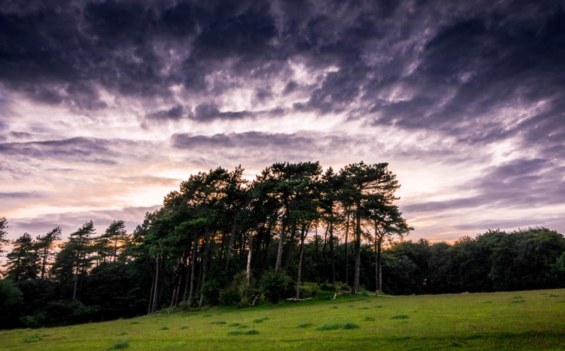
Crippet's Barrow
Crippet's Barrow submitted by Humbucker : Crippet's / Shurdington Long Barrow from the south east. I visited late afternoon in the Autumn of 2017. I had heard of very inquisitive horses in the field, but it was empty when I visited. (Vote or comment on this photo)
A surprisingly high Long Barrow (length 189 feet, maximum width 100' and height 12-20') made into a landscape feature with Scots pines planted on it in 1890.

The area is still called Barrow piece. At the east end, which was excavated before 1779, a flat stone is all that is visible now. In "Archeological Handbook of the county of Gloucester" of 1883 G.B. Witts wrote that the early excavator "uncovered a cromlech in which was found a skeleton and several article of which no satisfactory account can now obtained."

Planting up of the barrow protects from the plough, but the tree roots destroy the barrow features.

Further info from historicengland.org.uk
You may be viewing yesterday's version of this page. To see the most up to date information please register for a free account.


Crippet's Barrow
Crippet's Barrow submitted by Hweorfa : Clear view from the Cotswold Way. It is an imposing structure - much taller than it seems in the photo. (Vote or comment on this photo)

Crippet's Barrow
Crippet's Barrow submitted by Dabberdave : View from path a short distance from Cotswold Way. (Vote or comment on this photo)

Crippet's Barrow
Crippet's Barrow submitted by TheCaptain : Long distance view of Crippet's Long Barrow from the field entrance near the radio masts and reservoir, just about making out the large barrow in its tree covered setting. (Vote or comment on this photo)

Crippet's Barrow
Crippet's Barrow submitted by Humbucker : Crippet's / Shurdington from the north, Autumn of 2017. A lovely walk to reach the barrow & as is usual with lots of sites, it was deserted. (Vote or comment on this photo)

Crippet's Barrow
Crippet's Barrow submitted by durhamnature : Old drawing, from "Journal of British Archaeology" via archive.org

Crippet's Barrow
Crippet's Barrow submitted by durhamnature

Crippet's Barrow
Crippet's Barrow submitted by hamish : This is the only information here.

Crippet's Barrow
Crippet's Barrow submitted by hamish : This is a very large barrow, pity about the trees though. There was a skeleton found here,in a clumsy excavation in 1779. It was thought to be a Saxon burial because of a disintegrated helmet. (1 comment)

Crippet's Barrow
Crippet's Barrow submitted by hamish : This appears to be a Horned false portal

Crippet's Barrow
Crippet's Barrow submitted by hamish : This is Crippits/Shurdinton Barrow.Seen from a distance reminds me of Wndmill Tump. (1 comment)

Crippet's Barrow
Crippet's Barrow submitted by Celia_Haddon : CRIPPETS OR SHURDINGTON BARROW, COBERLEY. SO 9342 1737 A surprisingly high long barrow made into a landscape feature by Scots pines planted on it in l890, just off a footpath. Planting up barrow protects from the plough, even tree roots destroy the barrow features. The area is still called Barrow piece. At the east end, which was excavated before l779, a flat stone is all that is visible now. In...

Do not use the above information on other web sites or publications without permission of the contributor.
Click here to see more info for this site

Nearby sites

Click here to view sites on an interactive OS map

Key: Red: member's photo, Blue: 3rd party photo, Yellow: other image, Green: no photo - please go there and take one, Grey: site destroyed

Download sites to:
KML (Google Earth)
GPX (GPS waypoints)
CSV (Garmin/Navman)
CSV (Excel)

To unlock full downloads you need to sign up as a Contributory Member. Otherwise downloads are limited to 50 sites.


Turn off the page maps and other distractions

Nearby sites listing. In the following links * = Image available
 297m SSE 160° Dry Heathfield Barrow Round Barrow(s) (SO93521711)
 1.4km SSW 206° Crickley Hill* Hillfort (SO928161)
 1.5km S 178° Emma's Grove Round Barrows Round Barrow(s) (SO93481594)
 1.5km S 181° Barrow Wake Barrow Round Barrow(s) (SO93381585)
 1.7km NE 54° Leckhampton Hill* Hillfort (SO948184)
 1.8km ENE 56° Leckhampton Hill Barrow* Round Barrow(s) (SO94911838)
 2.3km S 190° Birdlip Barrow* Round Barrow(s) (SO9301015150)
 2.6km SSW 203° Birdlip Camp* Hillfort (SO924150)
 2.7km SE 130° Coberley* Chambered Tomb (SO95521564)
 2.8km SSW 202° Birdlip standing stones* Modern Stone Circle etc (SO9235214746)
 3.1km S 184° Birdlip Roundhouse Ancient Village or Settlement (SO932143)
 3.2km E 98° Seven Springs (Gloucestershire)* Holy Well or Sacred Spring (SO96631694)
 3.3km W 272° Badgeworth Round Barrow* Round Barrow(s) (SO90071750)
 4.7km SSW 209° West Tump* Long Barrow (SO9112213241)
 5.0km SW 227° Tile Well* Holy Well or Sacred Spring (SO89721395)
 5.2km SE 143° High Cross Stone (Elkstone)* Standing Stone (Menhir) (SO9653213246)
 5.2km SSW 204° Bucks Head Round Barrow* Round Barrow(s) (SO91321260)
 5.3km NNE 14° Cheltenham Museum* Museum (SO947225)
 5.4km NNE 16° Cheltenham Centre Stone* Marker Stone (SO9488422583)
 5.5km WNW 286° Churchdown Hill Camp* Hillfort (SO881189)
 5.6km SW 230° High Brotheridge* Misc. Earthwork (SO89121381)
 5.7km SSW 196° Climperwell* Holy Well or Sacred Spring (SO91891192)
 5.7km SSW 198° Climperwell Round Barrows* Round Barrow(s) (SO91641196)
 5.9km ENE 79° Lineover* Chambered Tomb (SO99231856)
 5.9km NNE 15° The Wish Stone* Marker Stone (SO950231)
View more nearby sites and additional images

<< Coberley

New Street Stone >>

Please add your thoughts on this site

Long Barrows of the Cotswolds, Darvill

Long Barrows of the Cotswolds, Darvill

Sponsors

Auto-Translation (Google)

Translate from English into:

"Crippet's Barrow" | Login/Create an Account | 6 News and Comments
  
Go back to top of page    Comments are owned by the poster. We aren't responsible for their content.
Re: Crippet's Barrow by Anonymous on Tuesday, 31 May 2022
Was browsing this area on NLS side by side Lidar, comparing to the 1885 OS one inch maps and the old OS has marked Stone Circles in the valley East and slightly North of this barrow. No sign of them today. Does anyone have more information?
[ Reply to This ]

The incredible stories of five of Gloucestershire's hidden ancient wonders by Andy B on Thursday, 02 July 2020
(User Info | Send a Message)
From Gloucestershire Live: These are some of our county's lesser-known historical sites, dating back thousands of years, from Crippets Long Barrow near Crickley Hill to the mystical Ring at Bishop's Cleeve.

Crippets Long Barrow

Long barrows were a type of burial monument used during the Neolithic period, which began around 6,000 years ago and represents the introduction of farming to Britain.

Burial in long barrows was communal, sometimes with only parts of the skeleton being interred, leading to the belief that these places were built as ‘houses of the dead’ for a community’s collective ancestry, perhaps being used for various ceremonies at important times of the year.

Although situated on private land, the now tree-topped Crippets long barrow can be seen from the Cotswold Way between Leckhampton Hill and Crickley Hill.

If you can imagine the original setting without the more recent neighbouring woodland, you can appreciate just how dramatic its quite deliberate location on the edge of the Cotswold escarpment would have been.

See all their site picks here
https://www.gloucestershirelive.co.uk/news/history/incredible-stories-five-gloucestershires-hidden-3977671
[ Reply to This ]

Re: Shurdington by 4clydesdale7 on Friday, 24 June 2011
(User Info | Send a Message)
This is well worth a visit and it really is a lot easier to find than the OS Explorer map (179) suggests - what I would call the archetypal Cotswold Long Barrow - a magnificent sight/site (both spellings apply) -
[ Reply to This ]

Re: Shurdington by coldrum on Tuesday, 16 February 2010
(User Info | Send a Message)
http://www.pastscape.org.uk/hob.aspx?hob_id=117459
[ Reply to This ]

Re: Shurdington by coldrum on Sunday, 03 January 2010
(User Info | Send a Message)
The following information from the Pastscape site.

"A Neolithic chambered long barrow, orienated east-west, located immediately below the crest of a hill in the Cotswolds. It is visible as a barrow mound 70 metres long by 34 metres wide and ranging in height from 2 metres to 6 metres. At the eastern end of the mound is an excavated depression, measuring about 20 metres east-west and 14 metres north-south, which contains a flat stone 1.8 metres long. This is thought to be the capstone of a chamber opened during the late 18th century. Two parallel ditches, from which material was excavated during the construction of the monument, lie on either side of the barrow mound to the north and south. These ditches are no longer visible at ground level, having become infilled over the years, but survive as buried features 3 metres wide. Rudder, writing in 1779, recorded that the barrow had been opened some years before. At a depth of 4.9 metres a burial chamber measuring 2.1 metres by 1.2 metres was discovered, containing a skeleton and a 'helmet, which was so corroded by rust that it fell to pieces on the slightest touch'. Scheduled."
[ Reply to This ]

Re: Shurdington by Anonymous on Wednesday, 26 January 2005
Only scores a two? More like a 3, or 3.5. Large and distinct. Well worth a visit. [Updated - thanks]
[ Reply to This ]

Your Name: Anonymous [ Register Now ]
Subject:


Add your comment or contribution to this page. Spam or offensive posts are deleted immediately, don't even bother

<<< What is five plus one as a number? (Please type the answer to this question in the little box on the left)
You can also embed videos and other things. For Youtube please copy and paste the 'embed code'.
For Google Street View please include Street View in the text.
Create a web link like this: <a href="https://www.megalithic.co.uk">This is a link</a>  

Allowed HTML is:
<p> <b> <i> <a> <img> <em> <br> <strong> <blockquote> <tt> <li> <ol> <ul> <object> <param> <embed> <iframe>

We would like to know more about this location. Please feel free to add a brief description and any relevant information in your own language.
Wir möchten mehr über diese Stätte erfahren. Bitte zögern Sie nicht, eine kurze Beschreibung und relevante Informationen in Deutsch hinzuzufügen.
Nous aimerions en savoir encore un peu sur les lieux. S'il vous plaît n'hesitez pas à ajouter une courte description et tous les renseignements pertinents dans votre propre langue.
Quisieramos informarnos un poco más de las lugares. No dude en añadir una breve descripción y otros datos relevantes en su propio idioma.